Location of Carter County in Oklahoma
This is a list of the National Register of Historic Places listings in Carter County, Oklahoma .
This is intended to be a complete list of the properties and districts on the National Register of Historic Places in Carter County , Oklahoma , United States . The locations of National Register properties and districts for which the latitude and longitude coordinates are included below, may be seen in a map.[1]
There are 23 properties and districts listed on the National Register in the county.
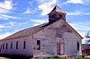
This National Park Service list is complete through NPS recent listings posted February 11, 2022. [2]
Current listings [ ]
[3] Name on the Register[4]
Image
Date listed[5]
Location
City or town
Description
1
Ardmore Carnegie Library
June 2, 2000 (#00000620 ) 511 Stanley, SW. 34°10′14″N 97°08′07″W / 34.170556°N 97.135278°W / 34.170556; -97.135278 (Ardmore Carnegie Library ) Ardmore
2
Ardmore Historic Commercial District
March 14, 1983 (#83002080 ) Main St. from the former Santa Fe railroad tracks to B St., N. Washington from Main to 2nd Ave., NE., and Caddo from Main to the northern side of 2nd Ave., NE. 34°10′16″N 97°07′41″W / 34.171111°N 97.128056°W / 34.171111; -97.128056 (Ardmore Historic Commercial District ) Ardmore
3
March 8, 2006 (#06000117 ) 220 West Broadway 34°10′27″N 97°07′50″W / 34.174167°N 97.130556°W / 34.174167; -97.130556 (Ardmore Municipal Auditorium ) Ardmore
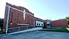
4
Bethel Missionary Baptist Church
January 12, 1995 (#94001519 ) Southeastern corner of the junction of Webster and Lane Sts. 34°28′56″N 97°27′41″W / 34.482222°N 97.461389°W / 34.482222; -97.461389 (Bethel Missionary Baptist Church ) Tatums
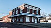
5
Black Theater of Ardmore
June 22, 1984 (#84002978 ) 536 E. Main St. 34°10′13″N 97°07′22″W / 34.170278°N 97.122778°W / 34.170278; -97.122778 (Black Theater of Ardmore ) Ardmore
6
Upload image December 5, 1977 (#77001090 ) 38 miles northwest of Ardmore 34°25′21″N 97°25′45″W / 34.4225°N 97.429167°W / 34.4225; -97.429167 (Brady Cabin ) Ardmore
7
March 22, 1985 (#85000678 ) 1st and B Sts., SW. 34°10′19″N 97°07′47″W / 34.171944°N 97.129722°W / 34.171944; -97.129722 (Carter County Courthouse ) Ardmore
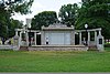
8
December 6, 2006 (#06001111 ) Southwest of the junction of W. Main and E St., SW. in about the middle of Central Park 34°10′25″N 97°08′03″W / 34.173611°N 97.134167°W / 34.173611; -97.134167 (Central Park Bandstand ) Ardmore
9
Upload image December 11, 2007 (#07001266 ) Junction of G St., NE. and the abandoned roadbed of the St. Louis – San Francisco Railway 34°10′44″N 97°07′06″W / 34.178889°N 97.118333°W / 34.178889; -97.118333 (Choctaw, Oklahoma and Gulf Railroad Viaduct ) Ardmore Demolished between 2009 and 2012
10
September 2, 2003 (#03000877 ) 519 N. Country Club Rd. 34°13′12″N 97°08′15″W / 34.22°N 97.1375°W / 34.22; -97.1375 (Dornick Hills Country Club ) Ardmore
11
July 11, 1984 (#84002981 ) 800 M St., NE. 34°10′49″N 97°07′21″W / 34.180278°N 97.1225°W / 34.180278; -97.1225 (Douglass High School Auditorium ) Ardmore
12
June 22, 1984 (#84002985 ) 13 6th St., SE. 34°10′10″N 97°07′14″W / 34.169444°N 97.120556°W / 34.169444; -97.120556 (Dunbar School ) Ardmore
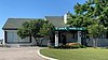
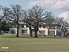
13
May 22, 1986 (#86001132 ) 400 Country Club Rd. 34°12′56″N 97°08′08″W / 34.215556°N 97.135556°W / 34.215556; -97.135556 (Galt-Franklin Home ) Ardmore
14
March 8, 2006 (#06000118 ) 600 Lake Murray Dr., S. 34°09′42″N 97°07′11″W / 34.161667°N 97.119722°W / 34.161667; -97.119722 (Hardy Murphy Coliseum ) Ardmore
15
April 7, 1994 (#94000280 ) Junction of 4th and Franklin Sts. 34°14′01″N 97°29′13″W / 34.233611°N 97.486944°W / 34.233611; -97.486944 (Healdton Armory ) Healdton
16
Upload image September 26, 1985 (#85002518 ) North of Wilson 34°13′02″N 97°24′34″W / 34.217222°N 97.409444°W / 34.217222; -97.409444 (Healdton Oil Field Bunk House ) Wilson
17
May 22, 1986 (#86001133 ) 400 Country Club Rd. 34°12′54″N 97°08′04″W / 34.215°N 97.134444°W / 34.215; -97.134444 (Johnson Home ) Ardmore
18
Lake Murray State Park
October 12, 2001 (#01001097 ) 1.9 miles southeast of the junction of U.S. Routes 70 and 77 34°04′56″N 97°04′13″W / 34.082222°N 97.070278°W / 34.082222; -97.070278 (Lake Murray State Park ) Ardmore
19
July 22, 1982 (#82003671 ) N. Washington and NE. 3rd 34°10′35″N 97°07′36″W / 34.176389°N 97.126667°W / 34.176389; -97.126667 (Oklahoma, New Mexico and Pacific Railroad Depot ) Ardmore
20
May 11, 1982 (#82003672 ) 323 F St., SW. 34°10′07″N 97°08′09″W / 34.168611°N 97.135833°W / 34.168611; -97.135833 (Sayre-Mann House ) Ardmore
21
September 9, 2013 (#13000703 ) 1501 3rd Ave., SW. 34°10′12″N 97°08′50″W / 34.1700°N 97.1473°W / 34.1700; -97.1473 (Turner House ) Ardmore
22
Upload image December 1, 2020 (#100005859 ) 1/8th of a mi. north of Seven Sisters Hills Rd. 34°17′50″N 96°58′36″W / 34.2972°N 96.9767°W / 34.2972; -96.9767 (Young Cemetery ) Ardmore vicinity
23
Upload image August 15, 1985 (#85001800 ) Off U.S. Route 70 34°10′20″N 97°29′58″W / 34.172222°N 97.499444°W / 34.172222; -97.499444 (Zaneis School Teacher's Dormitory ) Healdton Demolished
See also [ ] References [ ]
^ The latitude and longitude information provided in this table was derived originally from the National Register Information System, which has been found to be fairly accurate for about 99% of listings. Some locations in this table may have been corrected to current GPS standards.
^ National Park Service, United States Department of the Interior , "National Register of Historic Places: Weekly List Actions" , retrieved February 11, 2022.
^ Numbers represent an alphabetical ordering by significant words. Various colorings, defined here , differentiate National Historic Landmarks and historic districts from other NRHP buildings, structures, sites or objects.
^ "National Register Information System" . National Register of Historic Places National Park Service . March 13, 2009.^ The eight-digit number below each date is the number assigned to each location in the National Register Information System database, which can be viewed by clicking the number.
U.S. National Register of Historic Places
Topics Lists by state Lists by insular areas Lists by associated state Other areas Related
National Register of Historic Places portal Category
Cities Towns CDP Other Ghost towns Indian reservation Footnotes ‡This populated place also has portions in an adjacent county or counties
Oklahoma portal United States portal