National Register of Historic Places listings in Forrest County, Mississippi

Location of Forrest County in Mississippi
This is a list of the National Register of Historic Places listings in Forrest County, Mississippi.
This is intended to be a complete list of the properties and districts on the National Register of Historic Places in Forrest County, Mississippi, United States. Latitude and longitude coordinates are provided for many National Register properties and districts; these locations may be seen together in a map.[1]
There are 20 properties and districts listed on the National Register in the county.
- This National Park Service list is complete through NPS recent listings posted February 11, 2022.[2]
Current listings[]
| [3] | Name on the Register[4] | Image | Date listed[5] | Location | City or town | Description |
|---|---|---|---|---|---|---|
| 1 | Beverly Drive-In Theatre |  |
July 30, 2008 (#08000761) |
5320 U.S. Route 49 South at Old Airport Road 31°16′42″N 89°17′16″W / 31.278439°N 89.287719°W | Hattiesburg | Constructed 1948, destroyed by fire October 2010 |
| 2 |  |
September 2, 1997 (#97000930) |
Junction of Jackson Avenue and Jackson Avenue West 31°12′04″N 89°13′19″W / 31.201111°N 89.221944°W | Camp Shelby | At Camp Shelby. Constructed in 1938 to house officers | |
| 3 | Building 6981, Camp Shelby | 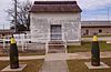 |
June 11, 1992 (#92000698) |
Camp Shelby 31°11′54″N 89°13′28″W / 31.19820°N 89.22439°W | Camp Shelby | Constructed in 1917 as a World War I Ammunition Magazine |
| 4 | April 14, 2000 (#00000380) |
Address Restricted | Hattiesburg | Prehistoric domestic and industry/processing/extraction site | ||
| 5 | East Sixth Street USO Building |  |
April 6, 2004 (#04000267) |
305 East Sixth Street 31°20′03″N 89°17′34″W / 31.334233°N 89.29275°W | Hattiesburg | Constructed in 1942, serves as African American Military History Museum |
| 6 | Eaton Elementary School |  |
July 16, 2008 (#08000676) |
1105 McInnis Avenue 31°19′26″N 89°16′50���W / 31.323758°N 89.280672°W | Hattiesburg | Constructed in 1905, vacant, not in use |
| 7 |  |
September 17, 1980 (#80002236) |
Roughly bounded by railroad tracks, Katie Ave., and Frederick and Hardy Sts. 31°19′13″N 89°17′13″W / 31.320278°N 89.286944°W | Hattiesburg | Sacred Heart Church is located in the Hattiesburg Historic Neighborhood District | |
| 8 | 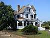 |
August 29, 1980 (#80002237) |
U.S. Routes 11 and 49; also roughly along Main, Market, Newman and Walnut Sts. 31°19′37″N 89°17′27″W / 31.326944°N 89.290833°W | Hattiesburg | Second set of boundaries represents a boundary increase of August 9, 2002. McLeod House (circa 1896) is in the Hub City Historic District. | |
| 9 |  |
November 5, 2010 (#10000885) |
6775 U.S. Route 49 31°21′40″N 89°21′03″W / 31.361111°N 89.350833°W | Hattiesburg | Constructed in 1885 as a double pen, dog-trot, log cabin | |
| 10 | The New York |  |
April 8, 1999 (#99000383) |
63 Fruitland Park Rd. 30°54′57″N 89°10′05″W / 30.915872°N 89.168017°W | Fruitland Park | Constructed in 1914 using Shingle style architecture |
| 11 | 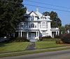 |
April 16, 1993 (#93000307) |
Roughly bounded by Jackson Street, Gordon's Creek, South, North, Providence, and Red Streets, and the Illinois Central railroad tracks 31°20′07″N 89°17′57″W / 31.335278°N 89.299167°W | Hattiesburg | The Montague House (built circa 1905) is in the North Main Street Historic District. | |
| 12 | 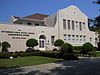 |
March 4, 1993 (#93000136) |
Roughly bounded by Hardy, Second, Railroad, and 11th Avenues 31°19′13″N 89°17′59″W / 31.320278°N 89.299722°W | Hattiesburg | Hattiesburg Public School Administration Building, formerly Camp Elementary (built c. 1907), and Trinity Episcopal Church are in the district. | |
| 13 | Old Hattiesburg High School | 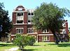 |
May 29, 1987 (#87000817) |
846 Main Street 31°19′45″N 89°17′44″W / 31.329167°N 89.295556°W | Hattiesburg | Constructed circa 1911, partially destroyed by arson 2007 |
| 14 |  |
August 9, 2002 (#02000856) |
Roughly along S. 22nd Ave. and S. 21st Ave., from Hardy to Mamie Sts. 31°19′18″N 89°19′24″W / 31.321667°N 89.323333°W | Hattiesburg | Parkhaven Arch (circa 1925) at Hardy Street and 22nd Street is in the Parkhaven Historic District. | |
| 15 |  |
May 29, 1979 (#79001307) |
Corner of Forrest and Front Streets 31°19′32″N 89°17′25″W / 31.325556°N 89.290278°W | Hattiesburg | Constructed circa 1929, Art Deco architectural style, used as civic theater and auditorium | |
| 16 | 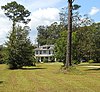 |
October 16, 1980 (#80002238) |
South of Hattiesburg off Memorial Drive 31°16′34″N 89°17′30″W / 31.276111°N 89.291667°W | Hattiesburg | Constructed circa 1925 as country house for Paul B. Johnson, Sr. | |
| 17 | January 25, 2018 (#100002028) |
901 Mamie St. 31°19′10″N 89°18′30″W / 31.319509°N 89.308196°W | Hattiesburg | |||
| 18 |  |
March 10, 2010 (#10000063) |
118 College Dr. 31°19′47″N 89°17′44″W / 31.329697°N 89.295483°W | Hattiesburg | ||
| 19 |  |
September 18, 1973 (#73001007) |
200 W. Pine St. 31°19′33″N 89°17′28″W / 31.325833°N 89.291111°W | Hattiesburg | Constructed in 1910 as Post Office, renovated in 1939 to serve as Courthouse. Now used as the Hattiesburg Municipal Court. | |
| 20 |  |
April 21, 1983 (#83000951) |
115 W. Pine Street 31°19′36″N 89°17′28″W / 31.326667°N 89.291111°W | Hattiesburg | Constructed in 1934, Art Deco architectural style |

See also[]
| Wikimedia Commons has media related to National Register of Historic Places in Forrest County, Mississippi. |
- List of National Historic Landmarks in Mississippi
- National Register of Historic Places listings in Mississippi
References[]
- ^ The latitude and longitude information provided in this table was derived originally from the National Register Information System, which has been found to be fairly accurate for about 99% of listings. Some locations in this table may have been corrected to current GPS standards.
- ^ National Park Service, United States Department of the Interior, "National Register of Historic Places: Weekly List Actions", retrieved February 11, 2022.
- ^ Numbers represent an alphabetical ordering by significant words. Various colorings, defined here, differentiate National Historic Landmarks and historic districts from other NRHP buildings, structures, sites or objects.
- ^ "National Register Information System". National Register of Historic Places. National Park Service. March 13, 2009.
- ^ The eight-digit number below each date is the number assigned to each location in the National Register Information System database, which can be viewed by clicking the number.
| Topics | |
|---|---|
| Lists by state |
|
| Lists by insular areas | |
| Lists by associated state | |
| Other areas | |
| Related | |
| |
Municipalities and communities of Forrest County, Mississippi, United States | ||
|---|---|---|
| Cities |  | |
| CDPs | ||
| Other communities | ||
| Ghost town | ||
| Footnotes | ‡This populated place also has portions in an adjacent county or counties | |
| ||
Categories:
- Forrest County, Mississippi
- Lists of National Register of Historic Places in Mississippi by county
- National Register of Historic Places in Forrest County, Mississippi