National Register of Historic Places listings in Hempstead County, Arkansas

Location of Hempstead County in Arkansas
This is a list of the National Register of Historic Places listings in Hempstead County, Arkansas.
This is intended to be a complete list of the properties and districts on the National Register of Historic Places in Hempstead County, Arkansas, United States. The locations of National Register properties and districts for which the latitude and longitude coordinates are included below, may be seen in a map.[1]
There are 28 properties and districts listed on the National Register in the county, including 1 National Historic Landmark. Another 5 properties were once listed but have been removed.
- This National Park Service list is complete through NPS recent listings posted September 3, 2021.[2]
Current listings[]


Former listings[]
| [3] | Name on the Register | Image | Date listed | Date removed | Location | City or town | Description |
|---|---|---|---|---|---|---|---|
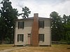
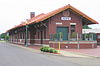
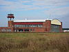
| 1 |  |
1978 (#78000591) | January 23, 2008 | 704 W. Avenue B | Hope | ||
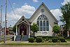
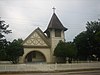
| 2 | Columbus Presbyterian Church | November 17, 1982 (#82000823) | June 12, 2013 | Highway 73 33°46′42″N 93°49′03″W / 33.778333°N 93.8175°W | Columbus | Listed November 17, 1982. Destroyed by fire[8] | |
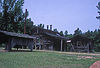
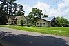
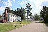
| 3 | Foster House | 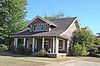 |
December 22, 1982 (#82000825) | September 30, 2019 | 303 N. Hervey St. 33°40′10″N 93°35′49″W / 33.669444°N 93.596944°W | Hope | |
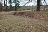
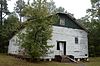
| 4 | November 3, 1989 (#89001940) | January 29, 2013 | Northwest of McCaskill | McCaskill | |||
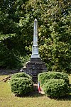
| 5 | 1982 (#82000827) | September 17, 1999 | Mulberry St. | Ozan |
See also[]
| Wikimedia Commons has media related to National Register of Historic Places in Hempstead County, Arkansas. |
- List of National Historic Landmarks in Arkansas
- National Register of Historic Places listings in Arkansas
References[]
- ^ The latitude and longitude information provided in this table was derived originally from the National Register Information System, which has been found to be fairly accurate for about 99% of listings. Some locations in this table may have been corrected to current GPS standards.
- ^ National Park Service, United States Department of the Interior, "National Register of Historic Places: Weekly List Actions", retrieved September 3, 2021.
- ^ Jump up to: a b Numbers represent an alphabetical ordering by significant words. Various colorings, defined here, differentiate National Historic Landmarks and historic districts from other NRHP buildings, structures, sites or objects.
- ^ "National Register Information System". National Register of Historic Places. National Park Service. March 13, 2009.
- ^ The eight-digit number below each date is the number assigned to each location in the National Register Information System database, which can be viewed by clicking the number.
- ^ Location derived from "August Fieldwork at Dooley's Ferry Archived 2011-07-20 at the Wayback Machine", Kadohadacho Chapter of the Arkansas Archeological Society, September 2008, accessed 2009-12-15; and coordinates derived from the GNIS feature record for Dooley's Ferry. The NRIS lists the site as "Address Restricted".
- ^ U.S. Geological Survey Geographic Names Information System: Mounds Cemetery
- ^ Jump up to: a b McLemore, Ken (April 10, 2013). "Cemetery on Nomination List". Hope Star. Retrieved June 18, 2013.
| show U.S. National Register of Historic Places |
|---|
| show Municipalities and communities of Hempstead County, Arkansas, United States |
|---|

Categories:
- Hempstead County, Arkansas
- Lists of National Register of Historic Places in Arkansas by county
- National Register of Historic Places in Hempstead County, Arkansas