National Register of Historic Places listings in Prairie County, Arkansas

Location of Prairie County in Arkansas
This is a list of the National Register of Historic Places listings in Prairie County, Arkansas.
This is intended to be a complete list of the properties on the National Register of Historic Places in Prairie County, Arkansas, United States.
There are 15 properties listed on the National Register in the county. Another three properties were once listed but have been removed.
- This National Park Service list is complete through NPS recent listings posted February 11, 2022.[1]
Current listings[]


Former listings[]
| [2] | Name on the Register | Image | Date listed | Date removed | Location | City or town | Description |
|---|---|---|---|---|---|---|---|
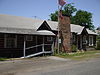
| 1 | July 23, 1998 (#98000881) | October 7, 2009 | 100 N. Hazen Ave. 34°46′53″N 91°34′48″W / 34.7814°N 91.58°W | Hazen | |||
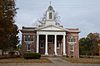
| 2 | November 20, 1992 (#92001616) | September 17, 1999 | Jct. of Prairie and Mason Sts. | De Valls Bluff | |||
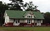
| 3 | 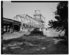 |
April 9, 1990 (#90000514) | June 1, 2005 | U.S. Route 70 over the White River | De Valls Bluff |
See also[]
| Wikimedia Commons has media related to National Register of Historic Places in Prairie County, Arkansas. |
- List of National Historic Landmarks in Arkansas
- National Register of Historic Places listings in Arkansas
References[]
- ^ National Park Service, United States Department of the Interior, "National Register of Historic Places: Weekly List Actions", retrieved February 11, 2022.
- ^ a b Numbers represent an alphabetical ordering by significant words. Various colorings, defined here, differentiate National Historic Landmarks and historic districts from other NRHP buildings, structures, sites or objects.
- ^ "National Register Information System". National Register of Historic Places. National Park Service. March 13, 2009.
- ^ The eight-digit number below each date is the number assigned to each location in the National Register Information System database, which can be viewed by clicking the number.
| Topics | |
|---|---|
| Lists by state |
|
| Lists by insular areas | |
| Lists by associated state | |
| Other areas | |
| Related | |
| |
Municipalities and communities of Prairie County, Arkansas, United States | ||
|---|---|---|
| Cities |  | |
| Towns | ||
| Unincorporated communities | ||
| Footnotes | ‡This populated place also has portions in an adjacent county of counties | |
| ||
Categories:
- Prairie County, Arkansas
- Lists of National Register of Historic Places in Arkansas by county
- National Register of Historic Places in Prairie County, Arkansas