[3] Name on the Register
Image
Date listed[4]
Location
Neighborhood
Description
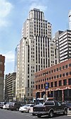
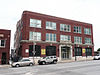
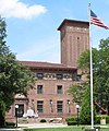
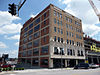
1
April 24, 1989 (#89000312 ) 1102 Grand Ave. 39°06′03″N 94°34′52″W / 39.100808°N 94.581048°W / 39.100808; -94.581048 (1102 Grand Ave Building ) Downtown
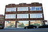
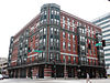
2
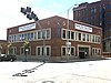
April 15, 2004 (#04000389 ) 1524 Grand Boulevard 39°05′42″N 94°34′53″W / 39.094908°N 94.581342°W / 39.094908; -94.581342 (1524 Grand Avenue Building ) Crossroads
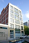
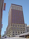
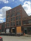
3
1901 McGee Street Automotive Service Building
January 22, 2009 (#08001359 ) 1901-1907 McGee St. 39°05′25″N 94°34′48″W / 39.090142°N 94.580041°W / 39.090142; -94.580041 (1901 McGee Street Automotive Service Building ) Crossroads
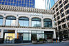
4
July 14, 2004 (#04000694 ) 609-611 E. 17th St. 39°05′35″N 94°34′34″W / 39.093095°N 94.576050°W / 39.093095; -94.576050 (Acme Brass and Machine Works Building ) Hospital Hill
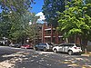
5
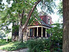
Upload image February 24, 2020 (#100004985 ) 1311-1315 West 13th St. 39°05′59″N 94°36′03″W / 39.0996°N 94.6008°W / 39.0996; -94.6008 (Charles Francis Adams Jr. Building )
6
July 5, 2006 (#06000543 ) 2700-2706 Troost Ave. and 1015 E. 27th St. 39°04′39″N 94°34′16″W / 39.077562°N 94.571178°W / 39.077562; -94.571178 (Alana Apartment Hotel ) Longfellow/Dutch Hill Demolished in 2018.
7
Argyle Building
August 17, 2005 (#05000891 ) 306 E. 12th St. 39°05′59″N 94°34′45″W / 39.099828°N 94.579295°W / 39.099828; -94.579295 (Argyle Building ) Downtown
8
Auto Coach Building
April 18, 2007 (#07000328 ) 1730-34 Oak St. 39°05′32″N 94°34′45″W / 39.092154°N 94.579125°W / 39.092154; -94.579125 (Auto Coach Building ) Crossroads
9
May 5, 2000 (#00000432 ) 915-917 Wyandotte 39°06′11″N 94°35′07″W / 39.103087°N 94.585286°W / 39.103087; -94.585286 (Baker–Vawter Building ) Downtown
10
October 18, 2003 (#03001057 ) 817 Cherry St. 39°06′13″N 94°34′33″W / 39.103543°N 94.575910°W / 39.103543; -94.575910 (Blackstone Hotel ) Downtown
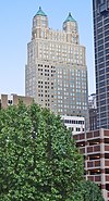
11
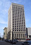
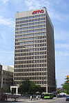
BMA Tower
August 21, 2002 (#02000886 ) 700 West Karnes (Should be 700 West 31st Street.) 39°04′20″N 94°35′37″W / 39.072111°N 94.593619°W / 39.072111; -94.593619 (BMA Tower )
12
Boley Building
March 9, 1971 (#71000467 ) 1130 Walnut St. 39°06′00″N 94°34′56″W / 39.1°N 94.582222°W / 39.1; -94.582222 (Boley Building ) Downtown
13
March 22, 1984 (#84002568 ) 1200 Grand Ave. 39°05′59″N 94°34′52″W / 39.099708°N 94.581144°W / 39.099708; -94.581144 (Bonfils Building ) Downtown
14
Buick Automobile Company Building
May 5, 2004 (#04000386 ) 216 Admiral Boulevard 39°06′20″N 94°34′48″W / 39.105514°N 94.579900°W / 39.105514; -94.579900 (Buick Automobile Company Building ) Downtown
15
September 5, 1975 (#75001067 ) 820 Baltimore Ave. 39°06′14″N 94°35′04″W / 39.103829°N 94.584519°W / 39.103829; -94.584519 (Bunker Building ) Downtown
16
Chambers Building
December 28, 2001 (#01001379 ) 25 E. 12th St. 39°05′59″N 94°34′57″W / 39.099771°N 94.582366°W / 39.099771; -94.582366 (Chambers Building ) Downtown
17
September 22, 2005 (#05001050 ) 2523, 2527, 2531, 2535, 2539, 2543, 2547, 2542, and 2544 Cherry St. 39°04′48″N 94°34′38″W / 39.080129°N 94.577177°W / 39.080129; -94.577177 (Cherry Street Colonnades Historic District ) Longfellow/Dutch Hill
18
October 21, 2004 (#04001161 ) 2697 West Paseo Boulevard (NRHP application incorrectly gives 2524 W. Paseo Boulevard.) 39°04′42″N 94°33′59″W / 39.078455°N 94.566320°W / 39.078455; -94.566320 (Christian Church Hospital )
19
February 17, 1983 (#83000996 ) 1801 Grand Ave. 39°05′30″N 94°34′51″W / 39.091667°N 94.580833°W / 39.091667; -94.580833 (City Bank Building ) Crossroads
20
Coates House Hotel
February 23, 1972 (#72000715 ) 1005 Broadway 39°06′08″N 94°35′17″W / 39.102222°N 94.588056°W / 39.102222; -94.588056 (Coates House Hotel ) Downtown
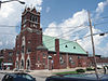
21
Coca-Cola Building
August 18, 1988 (#88001300 ) 2101-2111 Grand Ave. 39°05′15″N 94°34′53″W / 39.0874°N 94.5813°W / 39.0874; -94.5813 (Coca-Cola Building ) Crown Center Also known as the Western Auto Building
22
May 5, 2000 (#00000433 ) 2006-2012 Wyandotte St. 39°05′20″N 94°35′11″W / 39.0889°N 94.5863°W / 39.0889; -94.5863 (Columbia Building ) Crossroads
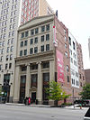
23
Commerce Tower
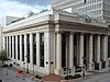
April 11, 2014 (#14000141 ) 911 Main St. 39°06′12″N 94°34′58″W / 39.1033°N 94.5829°W / 39.1033; -94.5829 (Commerce Tower ) Downtown
24
November 9, 2015 (#15000772 ) Bounded by E. 9th, Walnut, E. 10th & Main Sts. 39°06′10″N 94°34′57″W / 39.1028°N 94.5826°W / 39.1028; -94.5826 (Commerce Trust Company Historic District ) Downtown
25
August 8, 1983 (#83000997 ) 106 W. 11th St. 39°06′04″N 94°35′04″W / 39.1010°N 94.5844°W / 39.1010; -94.5844 (Continental Hotel ) Downtown Also known as Mark Twain Tower
26
September 16, 1982 (#82003143 ) 1828 Walnut St. 39°05′26″N 94°34′58″W / 39.0906°N 94.5828°W / 39.0906; -94.5828 (Thos. Corrigan Building ) Crossroads
27
May 18, 2018 (#100002424 ) 1105-1107 Hickory St. 39°06′05″N 94°36′05″W / 39.1014°N 94.6014°W / 39.1014; -94.6014 (The Crane Company Building )
28
Creamery Package Manufacturing Company Building
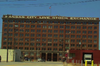
November 7, 2016 (#16000764 ) 1408-1410 W. 12th St. 39°06′03″N 94°36′06″W / 39.1009°N 94.6018°W / 39.1009; -94.6018 (Creamery Package Manufacturing Company Building )
29
Upload image December 22, 2000 (#00001565 ) Roughly bounded by Southwest Boulevard, W. 20th St., Baltimore Ave., W. 22nd St., and Broadway 39°05′18″N 94°35′13″W / 39.0882°N 94.5869°W / 39.0882; -94.5869 (Crossroads Historic Freight District ) Crossroads
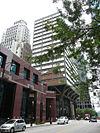
30
Upload image November 14, 2019 (#100004601 ) Bounded by Main St., Pershing Rd., 27th St., McGee St., Trfy, Grand Blvd. 39°05′21″N 94°34′57″W / 39.0891°N 94.5826°W / 39.0891; -94.5826 (Crown Center Historic District )
31
Louis Curtiss Studio Building
June 19, 1972 (#72000716 ) 1116-1120 McGee St. 39°06′01″N 94°34′48″W / 39.1003°N 94.5799°W / 39.1003; -94.5799 (Louis Curtiss Studio Building ) Downtown
32
January 29, 2009 (#08001387 ) 1000-1006 Grand Boulevard 39°06′08″N 94°34′51″W / 39.1023°N 94.5808°W / 39.1023; -94.5808 (Dierks Building ) Downtown
33
District I Upload image August 8, 1983 (#83001000 ) Roughly bounded by Baltimore Ave. and W. 12th, W. 13th, and Wyandotte Sts. 39°05′59″N 94°35′04″W / 39.0997°N 94.5844°W / 39.0997; -94.5844 (District I ) Downtown
34
Upload image October 9, 2020 (#100005660 ) Roughly bounded by Main, McGee, East 8th and East 10th Sts. 39°06′13″N 94°34′53″W / 39.1035°N 94.5815°W / 39.1035; -94.5815 (East Ninth Street-Grand Boulevard Historic District )
35
Upload image June 13, 2003 (#03000524 ) 1201-1207 Grand Boulevard 39°06′06″N 94°34′49″W / 39.1017°N 94.5803°W / 39.1017; -94.5803 (Exchange Building ) Downtown Demolished.
36
March 13, 2017 (#100000750 ) 720 Main St. 39°06′17″N 94°35′00″W / 39.1047°N 94.5832°W / 39.1047; -94.5832 (Executive Plaza Office Building ) Downtown
37
July 22, 2015 (#15000471 ) 101 W. 11th St. 39°06′03″N 94°35′04″W / 39.1009°N 94.5845°W / 39.1009; -94.5845 (The Fairfax Building ) Downtown
38
May 9, 2002 (#02000470 ) 1025 W. 8th St. 39°06′19″N 94°35′45″W / 39.1054°N 94.5958°W / 39.1054; -94.5958 (Faultless Starch Company Building ) West Bottoms
39
Federal Office Building
August 2, 2021 (#100006773 ) 601 East 12th St. 39°05′56″N 94°34′34″W / 39.0988°N 94.5761°W / 39.0988; -94.5761 (Federal Office Building ) AKA the Richard Bolling Federal Building
40
Federal Reserve Bank of Kansas City
April 10, 2007 (#07000327 ) 925 Grand Boulevard 39°06′14″N 94°34′49″W / 39.1039°N 94.5802°W / 39.1039; -94.5802 (Federal Reserve Bank of Kansas City ) Downtown
41
The Fidelity National Bank and Trust Company Building
August 14, 1997 (#97000908 ) 911 Walnut St. 39°06′11″N 94°34′54″W / 39.1031°N 94.5816°W / 39.1031; -94.5816 (The Fidelity National Bank and Trust Company Building ) Downtown
42
Fire Department Headquarters; Fire station No. 2
September 2, 1982 (#82003144 ) 1020 Central Ave. 39°06′05″N 94°35′14″W / 39.1015°N 94.5871°W / 39.1015; -94.5871 (Fire Department Headquarters; Fire station No. 2 ) Downtown
43
January 3, 1986 (#86000004 ) 2001 Grand Ave. 39°05′20″N 94°34′51″W / 39.088889°N 94.580833°W / 39.088889; -94.580833 (Firestone Building ) Crown Center
44
September 2, 1982 (#82003145 ) 1111 Grand Ave. 39°06′02″N 94°34′50″W / 39.100616°N 94.580689°W / 39.100616; -94.580689 (Gate City National Bank ) Downtown
45
April 18, 2007 (#07000326 ) 1712 Main St. 39°05′35″N 94°35′01″W / 39.092919°N 94.583659°W / 39.092919; -94.583659 (Globe Storage and Transfer Company Building ) Crossroads
46
Upload image July 25, 1985 (#85001610 ) 921 Walnut St. 39°06′10″N 94°34′53″W / 39.102778°N 94.581389°W / 39.102778; -94.581389 (Gloyd Building ) Downtown Demolished in 2001.
47
February 3, 2015 (#14001238 ) 718 Grand Ave. 39°06′18″N 94°34′52″W / 39.104862°N 94.580976°W / 39.104862; -94.580976 (Grand Avenue Garage ) Downtown
48
May 8, 1985 (#85001006 ) 205 E. 9th St. and 903 Grand Ave. 39°06′12″N 94°34′50″W / 39.103333°N 94.580556°W / 39.103333; -94.580556 (Grand Avenue Temple and Grand Avenue Temple Building ) Downtown
49
Graphic Arts Building
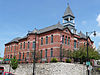
August 4, 2005 (#05000810 ) 934 Wyandotte St. 39°06′09″N 94°35′08″W / 39.102424°N 94.585674°W / 39.102424; -94.585674 (Graphic Arts Building ) Downtown
50
June 13, 2003 (#03000523 ) 2900 Gillham Rd. 39°04′25″N 94°34′44″W / 39.073744°N 94.579018°W / 39.073744; -94.579018 (Greenlease Cadillac Building ) Union Hill
51
September 2, 2003 (#03000866 ) 1015 Avenida de Cesar Chavez 39°05′09″N 94°35′49″W / 39.085783°N 94.596945°W / 39.085783; -94.596945 (Guadalupe Center )
52
January 22, 1979 (#79001367 ) 801 Walnut St. 39°06′15″N 94°34′54″W / 39.104302°N 94.581592°W / 39.104302; -94.581592 (Gumbel Building ) Downtown
53
May 5, 2000 (#00000434 ) 523 Grand Boulevard 39°06′29″N 94°34′48″W / 39.108062°N 94.580069°W / 39.108062; -94.580069 (Helping Hand Institute Building ) River Market
54
March 21, 2007 (#07000169 ) 1700 Oak St. 39°05′35″N 94°34′45″W / 39.093152°N 94.579116°W / 39.093152; -94.579116 (Hesse Carriage Company Building ) Crossroads
55
Holy Rosary Historic District
February 7, 2007 (#07000007 ) Roughly bounded by 5th and Campbell, 5th and Harrison, and 9th and E. Missouri Ave. (More precisely, 5th to Missouri, and Campbell to Harrison.) 39°06′34″N 94°34′21″W / 39.1094°N 94.572481°W / 39.1094; -94.572481 (Holy Rosary Historic District )
56
Upload image November 14, 2019 (#100004600 ) 922 Oak St. 39°06′09″N 94°34′42″W / 39.1025°N 94.5784°W / 39.1025; -94.5784 (Hoover Brothers Building )
57
Hotel Phillips
June 4, 1979 (#79001369 ) 106 W. 12th St. 39°06′00″N 94°35′05″W / 39.100030°N 94.584605°W / 39.100030; -94.584605 (Hotel Phillips ) Downtown
58
April 18, 1985 (#85000854 ) 1707 Jefferson St. 39°05′33″N 94°35′31″W / 39.092390°N 94.592020°W / 39.092390; -94.592020 (Frank M. Howe Residence )
59
Imperial Brewing Company Brewery
February 11, 2011 (#11000011 ) 2825 Southwest Boulevard 39°04′37″N 94°36′11″W / 39.076810°N 94.603073°W / 39.076810; -94.603073 (Imperial Brewing Company Brewery )
60
November 25, 2005 (#05001327 ) 318-320 E. 10th St. 39°06′09″N 94°34′45″W / 39.102392°N 94.579256°W / 39.102392; -94.579256 (Insurance Building-Consumers Cooperative Association Building ) Downtown
61
Inter-State Building
June 12, 2008 (#08000534 ) 417 E. 13th St./1300 Locust St. 39°05′54″N 94°34′40″W / 39.098273°N 94.577794°W / 39.098273; -94.577794 (Inter-State Building ) Downtown
62
October 23, 2017 (#100001759 ) 215 E. 18th St. 39°05′30″N 94°34′50″W / 39.091681°N 94.580455°W / 39.091681; -94.580455 (Interstate Securities Building )
63
Jenkins Music Company Building
March 2, 1979 (#79001370 ) 1217-1223 Walnut St. 39°05′57″N 94°34′55″W / 39.099148°N 94.581968°W / 39.099148; -94.581968 (Jenkins Music Company Building ) Downtown
64
Jensen-Salsbery Laboratories
July 16, 1985 (#85001574 ) 520 W. Pennway St. 39°05′16″N 94°35′27″W / 39.087778°N 94.590833°W / 39.087778; -94.590833 (Jensen-Salsbery Laboratories )
65
Kansas City Club Building
November 19, 2002 (#02001401 ) 1228 Baltimore Ave. 39°05′56″N 94°35′05″W / 39.098781°N 94.584734°W / 39.098781; -94.584734 (Kansas City Club Building ) Downtown
66
Kansas City Cold Storage Company Building
June 1, 2005 (#05000510 ) 500 E. 3rd St. 39°06′40″N 94°34′43″W / 39.111183°N 94.578607°W / 39.111183; -94.578607 (Kansas City Cold Storage Company Building ) River Market
67
April 5, 1984 (#84002571 ) 1600 Genessee St. 39°05′40″N 94°36′19″W / 39.094444°N 94.605278°W / 39.094444; -94.605278 (Kansas City Live Stock Exchange )
68
Kansas City Parks and Boulevards Historic District Upload image August 9, 2016 (#14000931 ) Roughly bounded by Missouri R. , Hardesty Ave., Armour Blvd. & State Line. 39°04′57″N 94°33′18″W / 39.082598°N 94.555041°W / 39.082598; -94.555041 (Kansas City Parks and Boulevards Historic District )
69
Kansas City Police Station Number 4
October 26, 2005 (#05001184 ) 103 W. 19th St. 39°05′27″N 94°35′07″W / 39.090781°N 94.585284°W / 39.090781; -94.585284 (Kansas City Police Station Number 4 ) Crossroads
70
Kansas City Power and Light Company Building
January 9, 2002 (#88001852 ) 1330 Baltimore Ave. 39°05′51″N 94°35′05″W / 39.097554°N 94.584720°W / 39.097554; -94.584720 (Kansas City Power and Light Company Building ) Downtown
71
January 29, 2018 (#100002032 ) 2645 Madison Ave. 39°04′43″N 94°35′43″W / 39.078723°N 94.595310°W / 39.078723; -94.595310 (Kansas City Power and Light Company Substation "A" )
72
Kansas City Public Library
May 23, 1977 (#77000807 ) 500 E. 9th St. 39°06′13″N 94°34′37″W / 39.103489°N 94.577015°W / 39.103489; -94.577015 (Kansas City Public Library ) Downtown
73
October 24, 2017 (#100001350 ) 1211 McGee St. 39°05′58″N 94°34′47″W / 39.099362°N 94.579761°W / 39.099362; -94.579761 (Kansas City Public Library and Board of Education Building ) Demolished in 2020.[5]
74
Kansas City Southern Railway Building
May 6, 2004 (#04000392 ) 114 W. 11th St. 39°06′04″N 94°35′07″W / 39.101076°N 94.585187°W / 39.101076; -94.585187 (Kansas City Southern Railway Building ) Downtown
75
June 24, 2019 (#100004102 ) 1729 Grand Blvd. 39°05′34″N 94°34′53″W / 39.0927°N 94.5813°W / 39.0927; -94.5813 (Kansas City Star Building )
76
Kansas City Terminal Railway Company Roundhouse Historic District
January 26, 2001 (#00001682 ) Junction of 27th St. and Southwest Boulevard 39°04′46″N 94°36′04″W / 39.079402°N 94.600990°W / 39.079402; -94.600990 (Kansas City Terminal Railway Company Roundhouse Historic District )
77
Kansas City Title and Trust Building
June 25, 2005 (#05000624 ) 927 Walnut St. 39°06′09″N 94°34′54″W / 39.102424°N 94.581786°W / 39.102424; -94.581786 (Kansas City Title and Trust Building ) Downtown
78
Kansas City Water Department Building
April 7, 1994 (#94000290 ) 201 Main St. 39°06′38″N 94°35′00″W / 39.110678°N 94.583456°W / 39.110678; -94.583456 (Kansas City Water Department Building ) River Market
79
Kansas City, Missouri Western Union Telegraph Building
February 12, 2003 (#03000010 ) 100-114 E. 7th St. 39°06′20″N 94°34′53″W / 39.105641°N 94.581391°W / 39.105641; -94.581391 (Kansas City, Missouri Western Union Telegraph Building ) Downtown
80
November 12, 2004 (#04001223 ) 422 Admiral Boulevard 39°06′20″N 94°34′40″W / 39.105521°N 94.577676°W / 39.105521; -94.577676 (Kelley-Reppert Motor Company Building ) Downtown
81
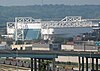
Kemper Arena
September 9, 2016 (#14000160 ) 1800 Genessee Street 39°05′31″N 94°36′21″W / 39.09194°N 94.60583°W / 39.09194; -94.60583 (Kemper Arena ) Downtown Revolutionary 1974 Helmut Jahn design has hosted political conventions as well as NBA and NHL games
82
Kirkwood Building
July 25, 2001 (#01000767 ) 1737-41 McGee St. 39°05′30″N 94°34′43″W / 39.091758°N 94.578730°W / 39.091758; -94.578730 (Kirkwood Building ) Crossroads
83
Land Bank Building
January 18, 1985 (#85000101 ) 15 W. 10th St. 39°06′08″N 94°35′01″W / 39.102093°N 94.583686°W / 39.102093; -94.583686 (Land Bank Building ) Downtown
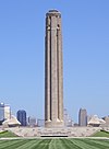
84
Liberty Memorial
October 6, 2000 (#00001148 ) 100 W. 26th St. 39°04′52″N 94°35′09″W / 39.081054°N 94.585957°W / 39.081054; -94.585957 (Liberty Memorial ) Crown Center
85
Liquid Carbonic Company Building
April 29, 1994 (#94000365 ) 2000 Baltimore St. 39°05′20″N 94°35′06″W / 39.088910°N 94.585057°W / 39.088910; -94.585057 (Liquid Carbonic Company Building ) Crossroads
86
Loew's Midland Theater–Midland Building
September 28, 1977 (#77000808 ) 1232-1234 Main St. and 1221-1233 Baltimore Ave. 39°05′56″N 94°35′01″W / 39.098829°N 94.583483°W / 39.098829; -94.583483 (Loew's Midland Theater–Midland Building ) Downtown
87
R.A. Long Building
January 8, 2003 (#02001683 ) 928 Grand Boulevard 39°06′09″N 94°34′52″W / 39.102372°N 94.581088°W / 39.102372; -94.581088 (R.A. Long Building ) Downtown
88
January 12, 2012 (#11001018 ) 1509-13 Baltimore Ave. 39°05′44″N 94°35′04″W / 39.095578°N 94.584525°W / 39.095578; -94.584525 (Lowe and Campbell Sporting Goods Building ) Crossroads
89
Mainstreet Theatre
February 15, 2007 (#07000043 ) 1400 Main St. 39°05′49″N 94°35′01″W / 39.097016°N 94.583619°W / 39.097016; -94.583619 (Mainstreet Theatre ) Downtown
90
June 26, 2006 (#06000542 ) 2429, 2433, and 2437 Tracy Ave. 39°04′57″N 94°34′04″W / 39.082374°N 94.567853°W / 39.082374; -94.567853 (Marks and Garvey Historic District )
91
February 5, 2013 (#12001257 ) 1412-1418 W. 12th St. 39°06′03″N 94°36′08″W / 39.100890°N 94.602232°W / 39.100890; -94.602232 (Albert Marty Building ) West Bottoms
92
Upload image September 13, 2021 (#100006891 ) 1110 Grand Blvd. 39°06′02″N 94°34′52″W / 39.1006°N 94.5810°W / 39.1006; -94.5810 (Mason Building )
93
Upload image May 20, 2018 (#100002427 ) Bounded by E 17th, & E 20th Sts., McGee St. at the 1700 & 1900 blocks, Alleys between McGee and Grand at 1800 blk. & McGee & Oak Sts. 39°05′30″N 94°34′51″W / 39.0917°N 94.5807°W / 39.0917; -94.5807 (McGee Street Automotive Historic District )
94
December 31, 2009 (#09000830 ) 1101 Walnut St. 39°06′03″N 94°34′55″W / 39.100939°N 94.581836°W / 39.100939; -94.581836 (Mercantile Bank & Trust Building ) Downtown
95
Midwest Hotel
May 6, 2004 (#04000394 ) 1925 Main St. 39°05′22″N 94°35′01″W / 39.0895°N 94.5835°W / 39.0895; -94.5835 (Midwest Hotel ) Crossroads
96
Upload image June 17, 2019 (#100004065 ) 1015 Mulberry St. 39°06′06″N 94°35′59″W / 39.1018°N 94.5998°W / 39.1018; -94.5998 (Moline Plow Company Building )
97
Monroe Hotel
May 6, 2004 (#04000395 ) 1904-06 Main St. 39°05′24″N 94°35′02″W / 39.0900°N 94.5839°W / 39.0900; -94.5839 (Monroe Hotel ) Crossroads
98
July 8, 2010 (#10000461 ) 819 E. 19th St. 39°05′24″N 94°34′24″W / 39.089941°N 94.573397°W / 39.089941; -94.573397 (Montgomery Ward and Company General Merchandise Warehouse ) Hospital Hill
99
May 10, 2016 (#16000234 ) 1225-1227 Union Avenue 39°06′09″N 94°35′57″W / 39.102455°N 94.599230°W / 39.102455; -94.599230 (C.A. Murdock Manufacturing Company Building )
100
National Bank of Commerce Building
May 5, 1999 (#99000530 ) 922-924 Walnut St. 39°06′09″N 94°34′55″W / 39.102571°N 94.582041°W / 39.102571; -94.582041 (National Bank of Commerce Building ) Downtown
101
National Garage Upload image May 5, 2000 (#00000436 ) 1100-1110 McGee St. 39°06′12″N 94°34′47″W / 39.103333°N 94.579722°W / 39.103333; -94.579722 (National Garage ) Downtown Demolished in 2004.
102
New York Life Building
July 8, 1970 (#70000336 ) 20 W. 9th St. 39°06′13″N 94°35′03″W / 39.103708°N 94.584072°W / 39.103708; -94.584072 (New York Life Building ) Downtown
103
Old New England Building
October 25, 1973 (#73001040 ) 112 W. 9th St. 39°06′14″N 94°35′07″W / 39.103797°N 94.585206°W / 39.103797; -94.585206 (Old New England Building ) Downtown
104
Upload image June 7, 1978 (#78001656 ) Roughly bounded by Independence Ave., 2nd, Delaware and Walnut Sts.; also 119, 207, and 213 Walnut St.; also 136 Main St.; also 140 Walnut St.; also roughly bounded by E. 2nd, Locust, and Walnut Sts., and E. Missouri Ave. 39°06′32″N 94°34′59″W / 39.108889°N 94.583056°W / 39.108889; -94.583056 (Old Town Historic District ) River Market Second through fifth sets of boundaries represent boundary increases of July 1, 2005 , October 5, 2005 , February 14, 2006 , and January 17, 2012
105
Palace Clothing Company Building
January 18, 1985 (#85000102 ) 1126-1128 Grand Ave. 39°06′00″N 94°34′52″W / 39.100050°N 94.581224°W / 39.100050; -94.581224 (Palace Clothing Company Building ) Downtown
106
April 30, 1980 (#80002368 ) 1044 Main St. 39°06′04″N 94°35′01″W / 39.101111°N 94.583611°W / 39.101111; -94.583611 (George B. Peck Dry Goods Company Building ) Downtown
107
October 25, 2011 (#11000764 ) 1908 Main St. 39°05′24″N 94°35′02″W / 39.089922°N 94.583891°W / 39.089922; -94.583891 (Thomas J. Pendergast Headquarters ) Crossroads
108
April 15, 2009 (#09000206 ) 604 W. 10th St. 39°06′09″N 94°35′29″W / 39.102630°N 94.591416°W / 39.102630; -94.591416 (Pennbroke Apartments ) Quality Hill
109
March 26, 1985 (#85000649 ) 1704 Jefferson St. 39°05′34″N 94°35′33″W / 39.092778°N 94.5925°W / 39.092778; -94.5925 (Joseph Grear Peppard House )
110
July 14, 2014 (#14000376 ) 1200 Union Ave. 39°06′09″N 94°35′54″W / 39.102544°N 94.598438°W / 39.102544; -94.598438 (Perfection Stove Company Building ) West Bottoms
111
July 23, 2009 (#09000552 ) 2719-37 and 2730 Troost Ave. 39°04′36″N 94°34′15″W / 39.076805°N 94.570745°W / 39.076805; -94.570745 (Nelle E. Peters Troost Avenue Historic District )
112
March 29, 2005 (#05000220 ) 901-937 McGee St., 301-311 E. 9th St., 300-310 E. Tenth St., and 906-912 Oak St. 39°06′10″N 94°34′46″W / 39.102827°N 94.579311°W / 39.102827; -94.579311 (Pickwick Hotel, Office Building, Parking Garage and Bus Terminal ) Downtown
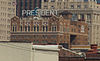
113
President Hotel
August 8, 1983 (#83001016 ) 1327-1335 Baltimore Ave. 39°05′52″N 94°35′03″W / 39.097778°N 94.584167°W / 39.097778; -94.584167 (President Hotel ) Downtown
114
Professional Building
July 17, 1979 (#79001373 ) 1101-1107 Grand Ave. 39°06′03″N 94°34′49″W / 39.100833°N 94.580278°W / 39.100833; -94.580278 (Professional Building ) Downtown
115
Quality Hill
July 7, 1978 (#78001657 ) Roughly bounded by Broadway, 10th, 14th, and Jefferson Sts. 39°06′00″N 94°35′26″W / 39.1°N 94.590556°W / 39.1; -94.590556 (Quality Hill ) Quality Hill
116
Upload image April 3, 2017 (#100000824 ) 817, 905, 929 Jefferson St. & 910 Pennsylvania Ave. 39°06′12″N 94°35′30″W / 39.103357°N 94.591762°W / 39.103357; -94.591762 (Quality Hill Center Historic District ) Quality Hill
117
January 21, 1999 (#98001636 ) 200 W. 5th St. 39°06′28″N 94°35′08″W / 39.107877°N 94.585585°W / 39.107877; -94.585585 (Richards and Conover Hardware Company Building ) River Market
118
Ridenour–Baker Grocery Company Building
April 21, 2014 (#14000161 ) 933 Mulberry St. 39°06′11″N 94°35′58″W / 39.103157°N 94.599432°W / 39.103157; -94.599432 (Ridenour–Baker Grocery Company Building ) West Bottoms
119
Rieger Hotel
May 6, 2004 (#04000396 ) 1922 Main St. 39°05′22″N 94°35′02″W / 39.089456°N 94.583909°W / 39.089456; -94.583909 (Rieger Hotel ) Crossroads
120
Sacred Heart Church, School and Rectory
November 14, 1978 (#78001659 ) 2540-2544 Madison Ave. and 910 W. 26th St. 39°04′50″N 94°35′44″W / 39.080556°N 94.595556°W / 39.080556; -94.595556 (Sacred Heart Church, School and Rectory )
121
Safeway Stores and Office and Warehouse Building
May 5, 2000 (#00000435 ) 2029-2043 Wyandotte St. 39°05′17″N 94°35′10″W / 39.087924°N 94.586005°W / 39.087924; -94.586005 (Safeway Stores and Office and Warehouse Building ) Crossroads
122
St. Mary's Episcopal Church
November 7, 1978 (#78001663 ) 1307 Holmes St. 39°05′53″N 94°34′28″W / 39.098056°N 94.574444°W / 39.098056; -94.574444 (St. Mary's Episcopal Church ) Downtown
123
Savoy Hotel and Grill
December 30, 1974 (#74001073 ) 219 W. 9th St. and 9th and Central Sts. 39°06′13″N 94°35′12″W / 39.103611°N 94.586667°W / 39.103611; -94.586667 (Savoy Hotel and Grill ) Downtown
124
Scarritt Building and Arcade
March 9, 1971 (#71000468 ) Corner of 9th and Grand Sts. and 819 Walnut St. 39°06′13″N 94°34′52″W / 39.1036°N 94.5811°W / 39.1036; -94.5811 (Scarritt Building and Arcade ) Downtown
125
May 9, 2002 (#02000469 ) 1009-1013 W. 8th St. 39°06′20″N 94°35′43″W / 39.1056°N 94.5953°W / 39.1056; -94.5953 (Sewall Paint and Glass Company Building ) West Bottoms
126
Upload image December 18, 2007 (#07001290 ) 1400-26 Guinotte Ave. 39°06′56″N 94°33′58″W / 39.1156°N 94.5661°W / 39.1156; -94.5661 (Smith and Sons Manufacturing Company Building ) Demolished about 2010.
127
Upload image October 19, 2020 (#100005679 ) 500 East 8th St. 39°06′15″N 94°34′36″W / 39.1043°N 94.5766°W / 39.1043; -94.5766 (Southwestern Bell Administration Building )
128
December 7, 2010 (#10000985 ) 2500 W. Pennyway St. 39°04′55″N 94°35′32″W / 39.0819°N 94.5922°W / 39.0819; -94.5922 (E. R. Squibb and Sons Building )
129
Standard Theatre
June 5, 1974 (#74001074 ) 300 W. 12th St. 39°06′01″N 94°35′14″W / 39.1002°N 94.5872°W / 39.1002; -94.5872 (Standard Theatre ) Downtown
130
July 18, 2007 (#07000702 ) 1811 Walnut 39°05′29″N 94°34′56″W / 39.0913°N 94.5823°W / 39.0913; -94.5823 (R.O. Stenzel & Company, Warehouse ) Crossroads
131
July 19, 1990 (#90001105 ) 924-926 Oak St. 39°06′09″N 94°34′43″W / 39.1025°N 94.5786°W / 39.1025; -94.5786 (Stine and McClure Undertaking Company Building ) Downtown
132
July 5, 2006 (#06000539 ) 415 Oak St. 39°06′34″N 94°34′45″W / 39.1095°N 94.5792°W / 39.1095; -94.5792 (Studna Garage Building ) River Market
133
Sweeney Automobile and Tractor School
April 11, 2014 (#14000142 ) 215 W. Pershing Rd. 39°05′00″N 94°35′13″W / 39.0832°N 94.5869°W / 39.0832; -94.5869 (Sweeney Automobile and Tractor School ) Crown Center
134
December 18, 2009 (#09001098 ) Generally bounded by Madison Ave. and Summit St., and 18th to 20th Sts. 39°05′25″N 94°35′38″W / 39.0903°N 94.5940°W / 39.0903; -94.5940 (Switzer School Buildings )
135
Upload image June 19, 1985 (#85001344 ) 531 Walnut St. 39°06′27″N 94°34′49″W / 39.1075°N 94.5804°W / 39.1075; -94.5804 (Temple Block Building ) River Market Demolished.
136
November 2, 2015 (#15000760 ) 920 Main St. 39°06′09″N 94°35′00″W / 39.1026°N 94.5834°W / 39.1026; -94.5834 (Ten Main Center )
137
April 14, 1994 (#94000286 ) 200-210 Walnut St. 39°06′39″N 94°34′57″W / 39.1107°N 94.5826°W / 39.1107; -94.5826 (Townley Metal & Hardware Company Building ) River Market
138
May 10, 2016 (#16000233 ) 1125 Grand Blvd. 39°06′00″N 94°34′51″W / 39.1001°N 94.5809°W / 39.1001; -94.5809 (Traders National Bank Building )
139
Upload image October 17, 2003 (#03001058 ) 3001-03 Gillham Rd. 39°04′21″N 94°34′43″W / 39.0724°N 94.5786°W / 39.0724; -94.5786 (Triangle Battery and Service Company Building ) Longfellow/Dutch Hill Demolished.
140
TWA Corporate Headquarters' Building
November 20, 2002 (#02001403 ) 1735-1741 Baltimore Ave.-1740 Main St. 39°05′31″N 94°35′04″W / 39.0919°N 94.5845°W / 39.0919; -94.5845 (TWA Corporate Headquarters' Building ) Crossroads
141
April 16, 2012 (#12000205 ) 2008-2020 Grand Boulevard 39°05′19″N 94°34′55″W / 39.0885°N 94.582°W / 39.0885; -94.582 (Twenty-Twenty Grand Building ) Crossroads
142
February 7, 2007 (#07000018 ) 900-906 E. 29th St. and 2843 N. Campbell, 910-912 E. 29th St., and 914 E. 29th St. 39°04′27″N 94°34′25″W / 39.0743°N 94.5735°W / 39.0743; -94.5735 (Twenty-Ninth Street Colonnaded Apartments Historic District ) Longfellow/Dutch Hill
143
U.S. Courthouse and Post Office-Kansas City, MO
November 20, 2007 (#07001231 ) 811 Grand Boulevard 39°06′14″N 94°34′49″W / 39.1038°N 94.5802°W / 39.1038; -94.5802 (U.S. Courthouse and Post Office-Kansas City, MO ) Downtown
144
April 19, 2016 (#16000183 ) 227 East 28th Terrace 39°04′33″N 94°34′53″W / 39.0758°N 94.5814°W / 39.0758; -94.5814 (Union Cemetery )
145
Union Station
February 1, 1972 (#72000719 ) Pershing Rd. and Main St.; also generally bounded by the Kansas City Terminal railroad tracks at Pennway, Pershing Rd., and Union Station 39°05′05″N 94°35′08″W / 39.084722°N 94.585556°W / 39.084722; -94.585556 (Union Station ) Crown Center Railroad tracks represent a boundary increase of May 6, 2004
146
May 26, 2004 (#04000213 ) 315 W. Pershing Rd. 39°04′58″N 94°35′17″W / 39.082862°N 94.588093°W / 39.082862; -94.588093 (United States Post Office-Kansas City ) Crown Center
147
October 18, 2003 (#03001055 ) 918-922 E. 5th St. 39°06′38″N 94°34′21″W / 39.110488°N 94.572440°W / 39.110488; -94.572440 (Joe Vaccaro Soda Water Manufacturing Company Building )
148
February 28, 2008 (#08000091 ) 1703 Wyandotte St. 39°05′36″N 94°35′04″W / 39.093245°N 94.584481°W / 39.093245; -94.584481 (Vitagraph Film Exchange Building ) Crossroads
149
Upload image September 17, 1999 (#99001158 ) Roughly bounded by Main St., 15th St., Grand St. and 17th St.; also 1612, 1616, 1620, and 1624 Grand Boulevard and 1705-07 and 1709 Walnut St.; also 1526, 1524, 1520, 1516-18, 1512-14, and 1508 Grand Boulevard 39°05′43″N 94°34′56″W / 39.095172°N 94.582347°W / 39.095172; -94.582347 (Walnut Street Warehouse and Commercial Historic District ) Crossroads Second and third sets of boundaries represent boundary increases of June 13, 2008 and December 17, 2008
150
August 8, 2001 (#01000837 ) 823 Walnut St. 39°06′13″N 94°34′54″W / 39.103613°N 94.581630°W / 39.103613; -94.581630 (Waltower Building ) Downtown
151
May 23, 1977 (#77000811 ) 1021 Pennsylvania Ave. 39°06′06″N 94°35′27″W / 39.101667°N 94.590833°W / 39.101667; -94.590833 (Maj. William Warner House ) Quality Hill
152
September 2, 1982 (#82003147 ) 1644 Wyandotte St. 39°05′35″N 94°35′10″W / 39.093056°N 94.586111°W / 39.093056; -94.586111 (Webster School ) Crossroads
153
Upload image November 15, 2016 (#16000771 ) W. 9th St., St. Louis Ave., Union Ave from Wyoming to W. of Mulberry Sts. 39°06′10″N 94°35′56″W / 39.102777°N 94.598786°W / 39.102777; -94.598786 (West Bottoms–North Historic District ) Downtown
154
Upload image September 9, 1982 (#82003148 ) Central and W. 11th Sts. 39°06′04″N 94°35′12″W / 39.101111°N 94.586667°W / 39.101111; -94.586667 (West Eleventh Street Historic District ) Downtown
155
November 7, 1976 (#76001113 ) Roughly bounded by Main, 8th, 10th, and Central Sts.; also the western side of the 100 block of 10th St. and the 1000 block of Baltimore Ave.; also 807-815 Wyandotte 39°06′12″N 94°35′05″W / 39.103333°N 94.584722°W / 39.103333; -94.584722 (West Ninth Street–Baltimore Avenue Historic District ) Downtown Second group of boundaries and the Wyandotte address represent boundary increases of November 20, 2002 and October 12, 2010
156
March 21, 2007 (#07000170 ) 304 W. 10th St. 39°06′09″N 94°35′14″W / 39.102472°N 94.587217°W / 39.102472; -94.587217 (Western Newspaper Union Building ) Downtown
157
Upload image October 25, 1979 (#79001375 ) Roughly bounded by 6th, Wyandotte, 8th, May, 11th, and Washington Sts.; also 701 Broadway & 330 W. 8th St. 39°06′14″N 94°35′15″W / 39.103889°N 94.5875°W / 39.103889; -94.5875 (Wholesale District ) Quality Hill , Downtown Second set of boundaries represents a boundary increase on April 23, 2013
158
Upload image October 9, 1985 (#85003102 ) Army Corps of Engineer Harbor 39°06′51″N 94°34′56″W / 39.114167°N 94.582222°W / 39.114167; -94.582222 (WILLIAM S. MITCHELL (dredge) River Market Destroyed in a 1993 flood.[6]
159
Upload image June 27, 2014 (#14000377 ) 703 E. 10th St. 39°06′07″N 94°34′28″W / 39.1020°N 94.5745°W / 39.1020; -94.5745 (The Wiltshire Apartment Hotel ) Downtown Demolished 2013.