From Wikipedia, the free encyclopedia
Location of Jefferson County in Mississippi
This is a list of the National Register of Historic Places listings in Jefferson County, Mississippi .
This is intended to be a complete list of the properties and districts on the National Register of Historic Places in Jefferson County , Mississippi , United States . Latitude and longitude coordinates are provided for many National Register properties and districts; these locations may be seen together in a map.[1]
There are 25 properties and districts listed on the National Register in the county.
This National Park Service list is complete through NPS recent listings posted February 11, 2022. [2]
Current listings [ ]
[3] Name on the Register[4]
Image
Date listed[5]
Location
City or town
Description
1
Blantonia Plantation House Upload image March 4, 1993 (#93000145 ) 3 miles east of Red Lick on an unmarked road off Mississippi Highway 552 31°48′06″N 90°55′55″W / 31.8017°N 90.9319°W / 31.8017; -90.9319 (Blantonia Plantation House ) Lorman
2
Cedar Grove Place Upload image March 28, 1979 (#79001317 ) 31°42′36″N 91°14′39″W / 31.71°N 91.2442°W / 31.71; -91.2442 (Cedar Grove Place ) Church Hill
3
China Grove Upload image April 3, 1980 (#80002254 ) West of Lorman off U.S. Route 61 31°49′43″N 91°03′50″W / 31.8286°N 91.0639°W / 31.8286; -91.0639 (China Grove ) Lorman
4
Christ Church
May 6, 1977 (#77000790 ) 31°42′54″N 91°14′17″W / 31.715°N 91.2381°W / 31.715; -91.2381 (Christ Church ) Church Hill
5
Upload image September 8, 2000 (#00001054 ) and Church Hill Rd., 1 mile south of Christ Episcopal Church 31°42′27″N 91°14′37″W / 31.7075°N 91.2436°W / 31.7075; -91.2436 (Church Hill Rural Historic District ) Natchez
6
Coon Box Fork Bridge Upload image May 23, 1979 (#79003429 ) Coon Box Rd. 31°47′25″N 91°05′37″W / 31.7903°N 91.0936°W / 31.7903; -91.0936 (Coon Box Fork Bridge ) Coon Box Destroyed in 2015.
7
Hays House Upload image March 10, 2009 (#09000111 ) 18800 U.S. Route 61 , S. 31°49′28″N 91°02′54″W / 31.8244°N 91.0482°W / 31.8244; -91.0482 (Hays House ) Lorman
8
Hughes-Clark House Upload image August 3, 1987 (#87001260 ) 221 Poindexter St. 31°42′40″N 91°03′36″W / 31.7111°N 91.06°W / 31.7111; -91.06 (Hughes-Clark House ) Fayette
9
Upload image January 24, 2019 (#100003343 ) 291 Chapel Hill Rd. 31°40′45″N 91°14′04″W / 31.6792°N 91.2344°W / 31.6792; -91.2344 (Jefferson Chapel A.M.E. Church and Cemetery ) Natchez
10
Laurietta Upload image November 24, 1980 (#80002253 ) South of Fayette off Mississippi Highway 33 31°40′45″N 91°04′56″W / 31.6792°N 91.0822°W / 31.6792; -91.0822 (Laurietta ) Fayette
11
Upload image June 29, 1989 (#89000447 ) Address Restricted Lorman
12
Oak Grove Upload image February 22, 1979 (#79001318 ) 31°42′42″N 91°14′22″W / 31.7117°N 91.2394°W / 31.7117; -91.2394 (Oak Grove ) Church Hill
13
Old Hill Place Bridge Upload image May 23, 1979 (#79003430 ) Hill Rd. 31°40′09″N 91°10′52″W / 31.6692°N 91.1811°W / 31.6692; -91.1811 (Old Hill Place Bridge ) Fayette
14
Pecan Grove Upload image March 13, 1980 (#80002252 ) North of Church Hill off 31°44′06″N 91°13′51″W / 31.735°N 91.2308°W / 31.735; -91.2308 (Pecan Grove ) Church Hill
15
Upload image March 10, 2010 (#10000064 ) 3080 Poplar Hill Rd. 31°45′50″N 91°05′37″W / 31.7639°N 91.0936°W / 31.7639; -91.0936 (Poplar Hill Grade School ) Fayette
16
Richland Upload image July 5, 1984 (#84002227 ) Off 31°45′07″N 91°11′54″W / 31.7519°N 91.1983°W / 31.7519; -91.1983 (Richland ) Church Hill
17
Rodney Center Historic District
August 29, 1980 (#80002255 ) Northwest of Lorman 31°51′40″N 91°11′52″W / 31.8611°N 91.1978°W / 31.8611; -91.1978 (Rodney Center Historic District ) Lorman
18
Rodney Presbyterian Church
February 6, 1973 (#73001018 ) West of Alcorn in the village of Rodney 31°51′46″N 91°11′59″W / 31.8628°N 91.1998°W / 31.8628; -91.1998 (Rodney Presbyterian Church ) Alcorn
19
Rosswood Upload image December 8, 1978 (#78001606 ) East of Lorman on Mississippi Highway 552 31°49′08″N 91°00′43″W / 31.8189°N 91.0119°W / 31.8189; -91.0119 (Rosswood ) Lorman
20
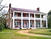
Springfield Plantation
November 23, 1971 (#71000454 ) 8 miles west of Fayette off 31°44′46″N 91°11′35″W / 31.7461°N 91.1931°W / 31.7461; -91.1931 (Springfield Plantation ) Fayette Where Andrew Jackson married Rachel Donelson Robards .
21
Upload image May 13, 2021 (#100006555 ) 93 Gilchrist St. Coordinates missing
Fayette
22
Union Church Presbyterian Church
July 18, 1979 (#79001322 ) 31°40′58″N 90°47′26″W / 31.6828°N 90.7906°W / 31.6828; -90.7906 (Union Church Presbyterian Church ) Union Church
23
Woodland Plantation Upload image November 27, 1978 (#78001605 ) South of Church Hill on 31°40′00″N 91°13′54″W / 31.6667°N 91.2317°W / 31.6667; -91.2317 (Woodland Plantation ) Church Hill
24
Wyolah Plantation Upload image May 30, 1985 (#85001168 ) Off 31°42′10″N 91°14′47″W / 31.7028°N 91.2464°W / 31.7028; -91.2464 (Wyolah Plantation ) Church Hill
25
Youngblood Bridge Upload image May 23, 1979 (#79003428 ) Youngblood Rd. 31°38′00″N 90°48′51″W / 31.6333°N 90.8142°W / 31.6333; -90.8142 (Youngblood Bridge ) Union Church
See also [ ] References [ ]
^ The latitude and longitude information provided in this table was derived originally from the National Register Information System, which has been found to be fairly accurate for about 99% of listings. Some locations in this table may have been corrected to current GPS standards.
^ National Park Service, United States Department of the Interior , "National Register of Historic Places: Weekly List Actions" , retrieved February 11, 2022.
^ Numbers represent an alphabetical ordering by significant words. Various colorings, defined here , differentiate National Historic Landmarks and historic districts from other NRHP buildings, structures, sites or objects.
^ "National Register Information System" . National Register of Historic Places National Park Service . March 13, 2009.^ The eight-digit number below each date is the number assigned to each location in the National Register Information System database, which can be viewed by clicking the number.
Topics Lists by state Lists by insular areas Lists by associated state Other areas Related
National Register of Historic Places portal Category
Categories :
Jefferson County, Mississippi Lists of National Register of Historic Places in Mississippi by county National Register of Historic Places in Jefferson County, Mississippi Hidden categories:
Articles using NRISref without a reference number Lists of coordinates Geographic coordinate lists Articles with Geo NRHP list missing coordinates Commons category link is on Wikidata