[3] Name on the Register
Image
Date listed[4]
Location
City or town
Description
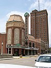
1
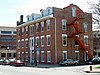
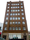
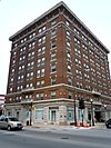
Arcada Theater Building
August 16, 1994 (#94000977 ) 105 E. Main St. and 1st Ave. 41°54′49″N 88°18′43″W / 41.913611°N 88.311944°W / 41.913611; -88.311944 (Arcada Theater Building ) St. Charles
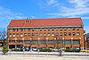
2
Aurora College Complex
February 16, 1984 (#84001126 ) 347 S. Gladstone Ave. 41°45′17″N 88°20′52″W / 41.754722°N 88.347778°W / 41.754722; -88.347778 (Aurora College Complex ) Aurora Eckhart, Davis, and Wilkinson Halls were the first buildings at Aurora College. The school, which moved to Aurora from Mendota , was long affiliated with the Advent Christian Church . Eckhart was the main hall, and the other two served as dormitories.
3
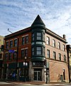
Aurora Elks Lodge No. 705
March 31, 1980 (#80001369 ) 77 S. Stolp Ave. 41°45′23″N 88°19′02″W / 41.756389°N 88.317222°W / 41.756389; -88.317222 (Aurora Elks Lodge No. 705 ) Aurora
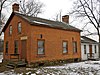
4
Batavia Institute
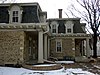
August 13, 1976 (#76000712 ) 333 S. Jefferson St. 41°50′40″N 88°18′59″W / 41.844444°N 88.316389°W / 41.844444; -88.316389 (Batavia Institute ) Batavia
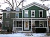
5
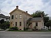
William Beith House
December 7, 1983 (#83003575 ) 6 Indiana St. 41°54′40″N 88°18′46″W / 41.911111°N 88.312778°W / 41.911111; -88.312778 (William Beith House ) St. Charles
6
Campana Factory
April 6, 1979 (#79000841 ) Roughly along Illinois Route 31 and Campana Rd. 41°51′54″N 88°18′58″W / 41.865°N 88.316111°W / 41.865; -88.316111 (Campana Factory ) Batavia A state-of-the-art factory built in 1936 for The Campana Company , a cosmetics manufacturer. It is an example of the 1930s Streamline Moderne trend. The factory incorporated many innovative elements, such as air conditioning and a unique assembly line method.
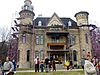
7
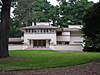
Campton Town Hall
November 24, 1980 (#80001378 ) W of Wasco at Town Hall Rd. and IL 64 41°55′56″N 88°25′45″W / 41.932222°N 88.429167°W / 41.932222; -88.429167 (Campton Town Hall ) Campton Hills
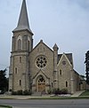
8
Central Geneva Historic District
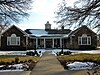
September 10, 1979 (#79000845 ) Roughly bounded by Fox River, South, 6th and W. State Sts.; also 0-200, 300-500 blocks S. 6th, 11-13 S. 7th, 600 blocks of State, James, Campbell, Fulton & South, 9,11 N. 2nd Sts. 41°53′08″N 88°18′30″W / 41.885556°N 88.308333°W / 41.885556; -88.308333 (Central Geneva Historic District ) Geneva Second set of addresses represent a boundary increase approved July 10, 2017
9
Chicago, Burlington, & Quincy Roundhouse and Locomotive Shop
February 16, 1978 (#78001154 ) Broadway and Spring Sts. 41°45′39″N 88°18′30″W / 41.760833°N 88.308333°W / 41.760833; -88.308333 (Chicago, Burlington, & Quincy Roundhouse and Locomotive Shop ) Aurora The roundhouse for the Chicago and Aurora Railroad (later Chicago, Burlington and Quincy Railroad ) was a major employer in Aurora from 1856 to 1974. After it sat vacant for twenty-one years, a group of investors led by Walter Payton converted it into an entertainment complex. It is the oldest standing limestone roundhouse in the United States.
10
Chicago, Burlington, and Quincy Railroad Depot
June 6, 1979 (#79000842 ) 155 Houston St. 41°51′05″N 88°18′37″W / 41.851389°N 88.310278°W / 41.851389; -88.310278 (Chicago, Burlington, and Quincy Railroad Depot ) Batavia The 1854 Gothic Revival train station was the first built for the Chicago, Burlington, and Quincy Railroad . It was redicated as a museum in 1974.
11
City Building
March 21, 1979 (#79000847 ) 15 N. Riverside Ave. 41°54′51″N 88°18′46″W / 41.914167°N 88.312778°W / 41.914167; -88.312778 (City Building ) St. Charles
12
Col. Ira C. Copley Mansion
March 29, 1978 (#78001155 ) 434 W. Downer Pl. 41°45′33″N 88°19′27″W / 41.759167°N 88.324167°W / 41.759167; -88.324167 (Col. Ira C. Copley Mansion ) Aurora
13
Copley Hospital
April 18, 2019 (#100003648 ) 301 Weston Ave. 41°44′49″N 88°19′05″W / 41.7469°N 88.3181°W / 41.7469; -88.3181 (Copley Hospital ) Aurora
14
Corron Farm
May 21, 2018 (#100001925 ) 7N761 Corron Rd. 41°58′49″N 88°24′18″W / 41.9803°N 88.4051°W / 41.9803; -88.4051 (Corron Farm ) St. Charles vicinity
15
Country Tea Room
February 25, 1999 (#99000164 ) 14N630 IL 25 42°04′36″N 88°15′36″W / 42.076667°N 88.26°W / 42.076667; -88.26 (Country Tea Room ) Dundee Township A historic restaurant built along future Illinois Route 25 . Max McGraw , who brought the Toastmaster to the domestic market, purchased the building in 1926 and thrived as a tearoom . It was later converted to a full restaurant to meet the changing demands of travelers.
16
Dundee Township Historic District
March 7, 1975 (#75000666 ) Both sides of Fox River, including sections of E. Dundee, W. Dundee, and Carpentersville 42°06′07″N 88°16′55″W / 42.101944°N 88.281944°W / 42.101944; -88.281944 (Dundee Township Historic District ) East Dundee West Dundee Carpentersville
17
Durant House
June 18, 1976 (#76000714 ) NW of St. Charles off Dean St. 41°55′38″N 88°20′50″W / 41.927222°N 88.347222°W / 41.927222; -88.347222 (Durant House ) St. Charles Township
18
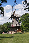
Dutch Mill
June 4, 1979 (#79000843 ) N of Batavia off IL 25 41°52′17″N 88°18′19″W / 41.871389°N 88.305278°W / 41.871389; -88.305278 (Dutch Mill ) Batavia
19
Elgin Academy
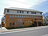
October 8, 1976 (#76000713 ) 350 Park St. 42°02′29″N 88°16′40″W / 42.041389°N 88.277778°W / 42.041389; -88.277778 (Elgin Academy ) Elgin
20
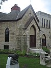
Elgin Downtown Commercial District
December 22, 2014 (#14001067 ) Roughly bounded by Division, Villa, Center, Fulton & Grove. 42°02′12″N 88°17′01″W / 42.036588°N 88.283507°W / 42.036588; -88.283507 (Elgin Downtown Commercial District ) Elgin
21
Elgin Historic District
May 9, 1983 (#83000318 ) Roughly bounded by Villa, Center, Park, N. Liberty, and S. Channing Sts. 42°02′11″N 88°16′28″W / 42.0364°N 88.2744°W / 42.0364; -88.2744 (Elgin Historic District ) Elgin
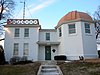
22
Elgin National Watch Company Observatory
August 16, 1994 (#94000976 ) 312 Watch St. 42°01′48″N 88°16′24″W / 42.03°N 88.2733°W / 42.03; -88.2733 (Elgin National Watch Company Observatory ) Elgin
23
Elgin Tower Building
May 22, 2002 (#02000542 ) 100 E. Chicago St. 42°02′15″N 88°17′03″W / 42.0375°N 88.2843°W / 42.0375; -88.2843 (Elgin Tower Building ) Elgin
24
Elizabeth Place
May 12, 2008 (#08000398 ) 316 Elizabeth Pl. 41°52′46″N 88°18′39″W / 41.8794°N 88.3108°W / 41.8794; -88.3108 (Elizabeth Place ) Geneva
25
Fabyan Villa
February 9, 1984 (#84001128 ) 1511 S. Batavia Ave. 41°52′16″N 88°18′43″W / 41.8711°N 88.3119°W / 41.8711; -88.3119 (Fabyan Villa ) Geneva
26
Fire Barn 5
August 5, 1991 (#91001002 ) 533 St. Charles Rd. 42°01′32″N 88°16′10″W / 42.0256°N 88.2694°W / 42.0256; -88.2694 (Fire Barn 5 ) Elgin
27
First Methodist Church of Batavia
March 19, 1982 (#82002546 ) 355 1st St. 41°50′54″N 88°18′50″W / 41.8483°N 88.3139°W / 41.8483; -88.3139 (First Methodist Church of Batavia ) Batavia
28
First Universalist Church
November 7, 1980 (#80001374 ) 55 Villa St. 42°02′10″N 88°16′48″W / 42.0361°N 88.28°W / 42.0361; -88.28 (First Universalist Church ) Elgin
29
Sam and Ruth Van Sickle Ford House
March 8, 2016 (#16000056 ) 404 S. Edgelawn Dr. 41°45′12″N 88°21′33″W / 41.7534°N 88.3591°W / 41.7534; -88.3591 (Sam and Ruth Van Sickle Ford House ) Aurora
30
Fox River House
May 4, 1976 (#76000710 ) 166 W. Galena 41°45′32″N 88°19′04″W / 41.7589°N 88.3178°W / 41.7589; -88.3178 (Fox River House ) Aurora
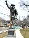
31
GAR Memorial Building
August 23, 1984 (#84001130 ) 23 E. Downer Pl. 41°45′24″N 88°18′56″W / 41.7567°N 88.3156°W / 41.7567; -88.3156 (GAR Memorial Building ) Aurora
32
Garfield Farm and Tavern
June 23, 1978 (#78001156 ) 3NO16 Garfield Rd. 41°54′36″N 88°24′01″W / 41.91°N 88.4003°W / 41.91; -88.4003 (Garfield Farm and Tavern ) Campton Hills
33
Geneva Country Day School
August 21, 1989 (#89001111 ) 1250 South St. 41°52′59″N 88°19′13″W / 41.8831°N 88.3203°W / 41.8831; -88.3203 (Geneva Country Day School ) Geneva
34
Gifford–Davidson House
May 31, 1980 (#80001375 ) 363-365 Prairie St. 42°02′03″N 88°16′39″W / 42.0342°N 88.2775°W / 42.0342; -88.2775 (Gifford–Davidson House ) Elgin
35
Graham Building
March 19, 1982 (#82002543 ) 33 S. Stolp Ave. 41°45′26″N 88°18′57″W / 41.7572°N 88.3158°W / 41.7572; -88.3158 (Graham Building ) Aurora
36
Gray–Watkins Mill
December 17, 1979 (#79000846 ) 211 N. River St. 41°43′46″N 88°20′25″W / 41.7294°N 88.3403°W / 41.7294; -88.3403 (Gray–Watkins Mill ) Montgomery
37
Mrs. A. W. Gridley House
February 3, 1993 (#92001850 ) 637 N. Batavia Ave. 41°51′36″N 88°18′49″W / 41.86°N 88.3136°W / 41.86; -88.3136 (Mrs. A. W. Gridley House ) Batavia
38
Healy Chapel
February 28, 1985 (#85000361 ) 332 W. Downer Pl. 41°45′33″N 88°19′23″W / 41.7592°N 88.3231°W / 41.7592; -88.3231 (Healy Chapel ) Aurora
39
Hobbs Building
June 17, 2021 (#100006645 ) 2-4 North River St. 41°45′33″N 88°19′00″W / 41.7593°N 88.3168°W / 41.7593; -88.3168 (Hobbs Building ) Aurora
40
Holy Cross Church
May 20, 1999 (#99000587 ) 14 N. Van Buren St. 41°51′01″N 88°18′10″W / 41.8503°N 88.3028°W / 41.8503; -88.3028 (Holy Cross Church ) Batavia
41
Hotel Arthur
March 15, 2005 (#04001300 ) 2-4 N. Broadway 41°45′33″N 88°18′47″W / 41.7592°N 88.3131°W / 41.7592; -88.3131 (Hotel Arthur ) Aurora
42
Hotel Aurora
June 3, 1982 (#82002544 ) 2 N. Stolp Ave. 41°45′30″N 88°18′54″W / 41.758333°N 88.315°W / 41.758333; -88.315 (Hotel Aurora ) Aurora
43
Hotel Baker
December 8, 1978 (#78001157 ) 100 W. Main St. 41°54′49″N 88°18′54″W / 41.913611°N 88.315°W / 41.913611; -88.315 (Hotel Baker ) St. Charles
44
Joel H. Hulburd House
May 4, 2011 (#11000244 ) 304 N. 2nd Ave. 41°54′59″N 88°18′43″W / 41.916389°N 88.311944°W / 41.916389; -88.311944 (Joel H. Hulburd House ) St. Charles
45
Hunt House
November 12, 1982 (#82000397 ) 304 Cedar Ave. 41°54′54″N 88°18′38″W / 41.915°N 88.310556°W / 41.915; -88.310556 (Hunt House ) St. Charles
46
Keystone Building
March 18, 1980 (#80001370 ) 30 S. Stolp Ave. 41°45′26″N 88°18′57″W / 41.757222°N 88.315833°W / 41.757222; -88.315833 (Keystone Building ) Aurora
47
Larkin Home for Children
December 31, 2018 (#100003264 ) 1212 Larkin Ave. 42°02′11″N 88°18′32″W / 42.036355°N 88.308874°W / 42.036355; -88.308874 (Larkin Home for Children ) Elgin
48
LaSalle Street Auto Row Historic District
August 1, 1996 (#96000856 ) 56-84 LaSalle St. and 57-83 S. LaSalle St. 41°45′18″N 88°18′48″W / 41.755°N 88.313333°W / 41.755; -88.313333 (LaSalle Street Auto Row Historic District ) Aurora
49
Library Hall
August 14, 1973 (#73000709 ) 21 N. Washington St. 42°06′37″N 88°17′16″W / 42.110278°N 88.287778°W / 42.110278; -88.287778 (Library Hall ) Carpentersville
50
Masonic Temple
March 19, 1982 (#82002545 ) 104 S. Lincoln Ave. 41°45′12″N 88°18′46″W / 41.753333°N 88.312778°W / 41.753333; -88.312778 (Masonic Temple ) Aurora Destroyed in a 2019 fire[5]
51
Memorial Washington Reformed Presbyterian Church
November 19, 1980 (#80001376 ) West of Elgin on W. Highland Ave. Rd. 42°03′51″N 88°23′28″W / 42.064167°N 88.391111°W / 42.064167; -88.391111 (Memorial Washington Reformed Presbyterian Church ) Elgin
52
Middle Avenue Historic District
October 24, 2016 (#16000735 ) Bounded by S. Lake, Cross, S. River & Gale Sts. 41°45′19″N 88°19′23″W / 41.755266°N 88.323145°W / 41.755266; -88.323145 (Middle Avenue Historic District ) Aurora
53
Robert and Elizabeth Muirhead House
January 12, 2016 (#15000965 ) 42W814 Rohrson Rd. 42°02′09″N 88°27′02″W / 42.035837°N 88.450635°W / 42.035837; -88.450635 (Robert and Elizabeth Muirhead House ) Plato Center
54
North Geneva Historic District
March 25, 1982 (#82002549 ) Roughly bounded by RR tracks, Fox River, Stevens and W. State Sts.; also 100-200 N. River Ln. 41°53′23″N 88°18′30″W / 41.889722°N 88.308333°W / 41.889722; -88.308333 (North Geneva Historic District ) Geneva Second set of addresses represent a boundary increase approved July 10, 2017
55
Oaklawn Farm
July 26, 1979 (#79000848 ) Army Trail and Dunham Rds. 41°57′02″N 88°16′10″W / 41.950556°N 88.269444°W / 41.950556; -88.269444 (Oaklawn Farm ) Wayne
56
Old Second National Bank
May 8, 1979 (#79000840 ) 37 S. River St. 41°45′28″N 88°19′06″W / 41.757778°N 88.318333°W / 41.757778; -88.318333 (Old Second National Bank ) Aurora
57
Paramount Theatre
March 18, 1980 (#80001371 ) 23 E. Galena Blvd. 41°45′25″N 88°18′54″W / 41.756944°N 88.315°W / 41.756944; -88.315 (Paramount Theatre ) Aurora
58
Ora Pelton House
August 12, 1982 (#82002548 ) 214 S. State St. 42°01′49″N 88°17′01″W / 42.030278°N 88.283611°W / 42.030278; -88.283611 (Ora Pelton House ) Elgin
59
Potter and Barker Grain Elevator
December 27, 2016 (#16000899 ) 1N298 La Fox Rd. 41°53′14″N 88°24′34″W / 41.887240°N 88.409391°W / 41.887240; -88.409391 (Potter and Barker Grain Elevator ) La Fox
60
Pure Oil Station
April 23, 2013 (#13000186 ) 502 W. State St. 41°53′17″N 88°18′40″W / 41.888107°N 88.31104°W / 41.888107; -88.31104 (Pure Oil Station ) Geneva
61
Riverbank Laboratories
November 28, 2003 (#03001204 ) 1512 Batavia Ave. 41°52′18″N 88°18′50″W / 41.871667°N 88.313889°W / 41.871667; -88.313889 (Riverbank Laboratories ) Geneva
62
St. Charles Hospital
June 7, 2010 (#10000312 ) 400 E New York St. 41°45′25″N 88°18′27″W / 41.756822°N 88.307425°W / 41.756822; -88.307425 (St. Charles Hospital ) Aurora
63
St. Charles Municipal Building
February 21, 1991 (#91000087 ) 2 E. Main St. 41°54′50″N 88°18′46″W / 41.913889°N 88.312778°W / 41.913889; -88.312778 (St. Charles Municipal Building ) St. Charles
64
St. Mary's Church of Gilberts
August 18, 1992 (#92001018 ) 10 Mattesen St. 42°06′23″N 88°22′30″W / 42.106389°N 88.375°W / 42.106389; -88.375 (St. Mary's Church of Gilberts ) Gilberts
65
Ephraim Smith House
June 6, 1980 (#80001377 ) NE of Sugar Grove 41°47′12″N 88°26′52″W / 41.786667°N 88.447778°W / 41.786667; -88.447778 (Ephraim Smith House ) Sugar Grove Township
66
Spring–Douglas Historic District
April 28, 2000 (#00000410 ) Roughly Spring St. and Douglas Ave., bet. River Bluff Rd. and Kimball Ave. 42°03′03″N 88°17′04″W / 42.050833°N 88.284444°W / 42.050833; -88.284444 (Spring–Douglas Historic District ) Elgin
67
Stearns–Wadsworth House
March 19, 1982 (#82002547 ) 1 S. 570 Bliss Rd. 41°50′40″N 88°24′26″W / 41.844444°N 88.407222°W / 41.844444; -88.407222 (Stearns–Wadsworth House ) Blackberry Township
68
Stolp Island Historic District
September 10, 1986 (#86001487 ) Stolp Island 41°45′27″N 88°18′56″W / 41.7575°N 88.315556°W / 41.7575; -88.315556 (Stolp Island Historic District ) Aurora
69
Stolp Woolen Mill Store
September 1, 1983 (#83000319 ) 2 W. Downer Pl. 41°45′25″N 88°18′59″W / 41.756944°N 88.316389°W / 41.756944; -88.316389 (Stolp Woolen Mill Store ) Aurora
70
William A. Tanner House
August 19, 1976 (#76000711 ) 304 Oak Ave. 41°45′49″N 88°19′06″W / 41.763611°N 88.318333°W / 41.763611; -88.318333 (William A. Tanner House ) Aurora
71
United Methodist Church of Batavia
July 28, 1983 (#83000320 ) 8 N. Batavia Ave. 41°51′02″N 88°18′42″W / 41.850556°N 88.311667°W / 41.850556; -88.311667 (United Methodist Church of Batavia ) Batavia
72
Andrew Weisel House
February 26, 1982 (#82002550 ) 312 N. 2nd Ave. 41°54′59″N 88°18′42″W / 41.916389°N 88.311667°W / 41.916389; -88.311667 (Andrew Weisel House ) St. Charles
73
West Side Historic District
August 13, 1986 (#86001484 ) Roughly bounded by W. Downer Pl., Lake St., Garfield Ave., and S. Highland St. 41°45′11″N 88°19′31″W / 41.753056°N 88.325278°W / 41.753056; -88.325278 (West Side Historic District ) Aurora
74
Louise White School
November 7, 1980 (#80001373 ) Washington Ave. 41°51′03″N 88°18′14″W / 41.850833°N 88.303889°W / 41.850833; -88.303889 (Louise White School ) Batavia
75
Judge Isaac Wilson House
May 9, 1985 (#85000978 ) 406 E. Wilson St. 41°51′00″N 88°18′04″W / 41.85°N 88.301111°W / 41.85; -88.301111 (Judge Isaac Wilson House ) Batavia
76
Wing Park Golf Course
February 18, 2009 (#09000027 ) 1000 Wing St. 42°02′51″N 88°18′17″W / 42.047486°N 88.304622°W / 42.047486; -88.304622 (Wing Park Golf Course ) Elgin