National Register of Historic Places listings in Coles County, Illinois
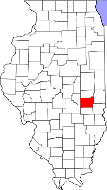
Location of Coles County in Illinois
This is a list of the National Register of Historic Places listings in Coles County, Illinois.
This is intended to be a complete list of the properties and districts on the National Register of Historic Places in Coles County, Illinois, United States. Latitude and longitude coordinates are provided for many National Register properties and districts; these locations may be seen together in a map.[1]
There are 21 properties and districts listed on the National Register in the county. Another three properties were once listed but have been removed.
- This National Park Service list is complete through NPS recent listings posted January 21, 2022.[2]
Current listings[]


Former listing[]
| [3] | Name on the Register | Image | Date listed | Date removed | Location | City or town | Description |
|---|---|---|---|---|---|---|---|
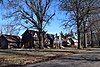
| 1 | January 30, 1986 (#86000135) | August 14, 2004 | 1632 Broadway Ave. | Mattoon | |||
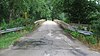
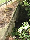
| 2 | Harrison St. Bridge |  |
November 30, 1981 (#81000213) | January 6, 2020 | East of Charleston 39°29′21″N 88°06′48″W / 39.489167°N 88.113333°W | Charleston | Demolished in 2011.[6] |
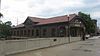
| 3 | Railway Express Agency Building | 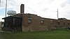 |
August 16, 1994 (#94000974) | January 2, 2020 | 1804 Western Ave. 39°28′59″N 88°22′36″W / 39.483056°N 88.376667°W | Mattoon | Demolished in 2013.[7] |
See also[]
| Wikimedia Commons has media related to National Register of Historic Places in Coles County, Illinois. |
- List of National Historic Landmarks in Illinois
- National Register of Historic Places listings in Illinois
References[]
- ^ The latitude and longitude information provided in this table was derived originally from the National Register Information System, which has been found to be fairly accurate for about 99% of listings. Some locations in this table may have been corrected to current GPS standards.
- ^ National Park Service, United States Department of the Interior, "National Register of Historic Places: Weekly List Actions", retrieved January 21, 2022.
- ^ a b Numbers represent an alphabetical ordering by significant words. Various colorings, defined here, differentiate National Historic Landmarks and historic districts from other NRHP buildings, structures, sites or objects.
- ^ "National Register Information System". National Register of Historic Places. National Park Service. March 13, 2009.
- ^ The eight-digit number below each date is the number assigned to each location in the National Register Information System database, which can be viewed by clicking the number.
- ^ "Archived copy" (PDF). Archived from the original (PDF) on 2013-12-24. Retrieved 2014-01-12.
{{cite web}}: CS1 maint: archived copy as title (link) - ^ "Once 'very busy' freight site torn down near midtown Mattoon".
| Lists by county |
|  |
|---|---|---|
| Chicago lists | ||
| Other lists |
| |
Municipalities and communities of Coles County, Illinois, United States | ||
|---|---|---|
| Cities | ||
| Villages | ||
| Townships | ||
| Unincorporated communities | ||
| Extinct community | ||
| Footnotes | ‡This populated place also has portions in an adjacent county or counties | |
| ||
Categories:
- National Register of Historic Places in Coles County, Illinois
- Lists of National Register of Historic Places in Illinois by county