Coles County, Illinois
Coles County | |
|---|---|
U.S. county | |
 | |
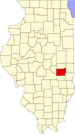 Location within the U.S. state of Illinois | |
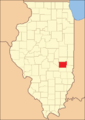
 Illinois's location within the U.S. | |
| Coordinates: 39°31′N 88°13′W / 39.51°N 88.22°W | |
| Country | |
| State | |
| Founded | December 25, 1830 |
| Named for | Edward Coles |
| Seat | Charleston |
| Largest city | Charleston |
| Area | |
| • Total | 510 sq mi (1,300 km2) |
| • Land | 508 sq mi (1,320 km2) |
| • Water | 1.8 sq mi (5 km2) 0.4% |
| Population (2010) | |
| • Total | 53,873 |
| • Estimate (2019) | 50,621 |
| • Density | 110/sq mi (41/km2) |
| Time zone | UTC−6 (Central) |
| • Summer (DST) | UTC−5 (CDT) |
| Congressional district | 15th |
| Website | www |

Coles County is a county located in the U.S. state of Illinois. As of the 2010 census, the population was 53,873.[1] Its county seat is Charleston,[2] which is also the home of Eastern Illinois University.
Coles County is part of the Charleston-Mattoon, IL Micropolitan Statistical Area.
History[]
Coles County was organized by European Americans on December 25, 1830 out of Clark and Edgar counties. It was named after Edward Coles,[3] the second governor of Illinois, from 1822 to 1826. The majority of the American settlers who founded Coles County, Illinois were either from the six New England states, or were born in upstate New York to parents who had moved to that region from New England shortly after the American Revolution. This population was referred to as "Yankee" settlers, descendants of the English Puritans who settled New England in the 1600s and developed generations there. They were part of a wave of New England farmers who headed west into the frontier of the Northwest Territory during the early 1800s. The completion of the Erie Canal led to an increase in New England migrants heading west into what were then the wilds of the old Northwest Territory. When the "Yankee" settlers originally reached what is today Coles County, Illinois, they found dense virgin forest and prairie.
The New England settlers laid out farms, constructed roads, erected government buildings and established post routes. They brought with them many of their "Yankee" values, such as staunch support for abolitionism as well as a passion for education. They quickly established schools in their communities. They were mostly members of the Congregationalist Church, though some were Episcopalian. As a result of the second Great Awakening, many had become Baptists or switched to Protestant denominations such as Methodism or Presbyterianism before moving to what is now Coles county. The prevalence of settlers from New England or born in upstate New York to parents who were from New England resulted in their establishing a culture that was continuous with that of New England for the first several decades of its history. As a result of this Coles county residents largely supported abolitionism in the antebellum period, and also the Republican Party as of the 1850s and 1860s.
Beginning in 1849, numerous German immigrants arrived in Coles County, refugees from the rebellions the year before in various principalities. This population overwhelmingly supported the abolition of slavery.
Irish Catholic immigrants who had fled the famine in their country also settled here. Illinois Democratic Senator Stephen Douglas was extremely popular amongst Irish Catholics immigrants in Coles County at this time. During the Civil War the Irish Catholic community of Coles County would overwhelmingly be copperheads.[4][5][6][7]

Coles County from the time of its creation to 1843

Coles County between 1843 and 1859
Coles County reduced to its current size in 1859 by the creation of Douglas County


Folklore representation in other media[]
Coles County has generated several well-known legends and folktales, including the Mad Gasser of Mattoon and accounts of the ghost of Mary Hawkins at Pemberton Hall. Michael Kleen has compiled many of these tales, including the "witch's grave" of St. Omer Cemetery and the story of "Rag Doll Cemetery," in his book Tales of Coles County, Illinois (2010).[8][9]
The legend of "Rag Doll Cemetery" was adapted for the screenplay of the independent film Rag Doll, filmed in 2010 primarily in and around Mattoon, Illinois.[10] The novel A Family Possessed (2000) by L. W. Stevenson, is based on a rural family's account of poltergeist activity at their home in the 1980s.[11]
Ashmore Estates has long been a part of local folklore. Originally serving as the almshouse at the Coles County Poor Farm, it is considered a haunted attraction and a place of interest for paranormal investigators.[12]
Geography[]
According to the U.S. Census Bureau, the county has a total area of 510 square miles (1,300 km2), of which 508 square miles (1,320 km2) is land and 1.8 square miles (4.7 km2) (0.4%) is water.[13]
Climate and weather[]
| Charleston, Illinois | ||||||||||||||||||||||||||||||||||||||||||||||||||||||||||||
|---|---|---|---|---|---|---|---|---|---|---|---|---|---|---|---|---|---|---|---|---|---|---|---|---|---|---|---|---|---|---|---|---|---|---|---|---|---|---|---|---|---|---|---|---|---|---|---|---|---|---|---|---|---|---|---|---|---|---|---|---|
| Climate chart (explanation) | ||||||||||||||||||||||||||||||||||||||||||||||||||||||||||||
| ||||||||||||||||||||||||||||||||||||||||||||||||||||||||||||
| ||||||||||||||||||||||||||||||||||||||||||||||||||||||||||||
In recent years, average temperatures in the county seat of Charleston have ranged from a low of 19 °F (−7 °C) in January to a high of 88 °F (31 °C) in July, although a record low of −27 °F (−33 °C) was recorded in January 1994 and a record high of 110 °F (43 °C) was recorded in July 1936. Average monthly precipitation ranged from 2.20 inches (56 mm) in January to 4.65 inches (118 mm) in July.[14]
Adjacent counties[]
- Douglas County - north
- Edgar County - northeast
- Clark County - southeast
- Cumberland County - south
- Shelby County - southwest
- Moultrie County - west
Major highways[]
 Interstate 57
 US Route 45
 Illinois Route 16
 Illinois Route 49
 Illinois Route 121
 Illinois Route 130
 Illinois Route 133
Demographics[]

| Historical population | |||
|---|---|---|---|
| Census | Pop. | %± | |
| 1840 | 9,616 | — | |
| 1850 | 9,335 | −2.9% | |
| 1860 | 14,203 | 52.1% | |
| 1870 | 25,235 | 77.7% | |
| 1880 | 27,042 | 7.2% | |
| 1890 | 30,093 | 11.3% | |
| 1900 | 34,146 | 13.5% | |
| 1910 | 34,517 | 1.1% | |
| 1920 | 35,108 | 1.7% | |
| 1930 | 37,315 | 6.3% | |
| 1940 | 38,470 | 3.1% | |
| 1950 | 40,328 | 4.8% | |
| 1960 | 42,860 | 6.3% | |
| 1970 | 47,815 | 11.6% | |
| 1980 | 52,260 | 9.3% | |
| 1990 | 51,644 | −1.2% | |
| 2000 | 53,196 | 3.0% | |
| 2010 | 53,873 | 1.3% | |
| 2019 (est.) | 50,621 | [15] | −6.0% |
| U.S. Decennial Census[16] 1790-1960[17] 1900-1990[18] 1990-2000[19] 2010-2013[1] | |||
As of the 2010 United States Census, there were 53,873 people, 21,463 households, and 11,963 families residing in the county.[20] The population density was 106.0 inhabitants per square mile (40.9/km2). There were 23,425 housing units at an average density of 46.1 per square mile (17.8/km2).[13] The racial makeup of the county was 92.9% white, 3.8% black or African American, 1.0% Asian, 0.2% American Indian, 0.6% from other races, and 1.5% from two or more races. Those of Hispanic or Latino origin made up 2.1% of the population.[20] In terms of ancestry, 25.6% were German, 16.4% were Irish, 11.1% were American, 10.0% were English, 3.4% were Polish, 2.9% were Italian, 2.5% were French, 2.1% were Dutch and 1.9% were Scots-Irish.[21]
Of the 21,463 households, 25.5% had children under the age of 18 living with them, 41.8% were married couples living together, 9.9% had a female householder with no husband present, 44.3% were non-families, and 31.4% of all households were made up of individuals. The average household size was 2.30 and the average family size was 2.87. The median age was 31.6 years.[20]
The median income for a household in the county was $36,457 and the median income for a family was $54,170. Males had a median income of $38,915 versus $28,781 for females. The per capita income for the county was $20,601. About 10.6% of families and 20.3% of the population were below the poverty line, including 20.6% of those under age 18 and 5.9% of those age 65 or over.[22]
Communities[]
Cities[]
- Charleston (seat)
- Mattoon
Villages[]
Unincorporated Communities[]
- Bushton
- Campbell
- Coles
- Cooks Mills
- Diona
- Dorans
- Embarrass
- Etna
- Fairgrange
- Fuller
- Hutton
- Janesville
- Jones
- Kings
- Lipsey
- Loxa
- Magnet
- Newby
- Paradise
- Rardin
- Trilla
- Wabash Point
Townships[]
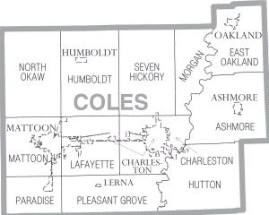
Coles County is divided into these twelve townships:
Education[]
- Eastern Illinois University
- Lake Land College
- Charleston Community Unit School District 1
- Mattoon Community Unit School District 2
- Oakland Community Unit School District 5
Politics[]
Coles County leans strongly towards the Republican Party in Presidential elections. Although it was carried by Illinoisian Barack Obama in 2008, the GOP regained the county in 2012 and Donald Trump won by 26 percent in 2016.
Notable people[]
- Thomas Lincoln, father of future President Abraham Lincoln, moved to Coles County in 1831 and died there in 1851.
See also[]
- National Register of Historic Places listings in Coles County, Illinois
- List of school districts in Illinois
References[]
- ^ Jump up to: a b "State & County QuickFacts". United States Census Bureau. Archived from the original on July 8, 2011. Retrieved July 4, 2014.
- ^ "Find a County". National Association of Counties. Archived from the original on May 31, 2011. Retrieved June 7, 2011.
- ^ Gannett, Henry (1905). The Origin of Certain Place Names in the United States. Govt. Print. Off. pp. 87.
- ^ The Yankee Exodus: An Account of Migration from New England (1968) by Stewart H. Holbrook
- ^ The Yankee West: Community Life on the Michigan Frontier (1996) by Susan E. Gray
- ^ Yankee Colonies across America: Cities upon the Hills (2015) by Chaim M. Rosenberg
- ^ Bonds of Loyalty: German-American and World War I by Frederick C. Luebke, Northern Illinois University Press, 1974 - ISBN 9780875800455
- ^ Tales of Coles County, Illinois. Black Oak Press, Illinois. 2010 [2004]. Archived from the original on July 29, 2010. Retrieved September 9, 2010.
- ^ "Student author gets creative with Coles history". Daily Eastern News. October 28, 2005. Archived from the original on March 3, 2016.
- ^ "Mattoon-based thriller gets a name". Journal Gazette/Times-Courier. May 14, 2010.
- ^ "A Ghost Story of local proportions". Journal Gazette/Times-Courier. October 28, 2000.
- ^ "TV team uses technology to root out spirits at Ashmore Estates". Times-Courier. July 20, 2008.
- ^ Jump up to: a b "Population, Housing Units, Area, and Density: 2010 - County". United States Census Bureau. Archived from the original on February 12, 2020. Retrieved July 11, 2015.
- ^ Jump up to: a b "Monthly Averages for Charleston, Illinois". The Weather Channel. Retrieved January 27, 2011.
- ^ "County Population Totals: 2010-2019". Retrieved March 3, 2021.
- ^ "U.S. Decennial Census". United States Census Bureau. Retrieved July 4, 2014.
- ^ "Historical Census Browser". University of Virginia Library. Retrieved July 4, 2014.
- ^ "Population of Counties by Decennial Census: 1900 to 1990". United States Census Bureau. Retrieved July 4, 2014.
- ^ "Census 2000 PHC-T-4. Ranking Tables for Counties: 1990 and 2000" (PDF). United States Census Bureau. Retrieved July 4, 2014.
- ^ Jump up to: a b c "DP-1 Profile of General Population and Housing Characteristics: 2010 Demographic Profile Data". United States Census Bureau. Archived from the original on February 13, 2020. Retrieved July 11, 2015.
- ^ "DP02 SELECTED SOCIAL CHARACTERISTICS IN THE UNITED STATES – 2006-2010 American Community Survey 5-Year Estimates". United States Census Bureau. Archived from the original on February 13, 2020. Retrieved July 11, 2015.
- ^ "DP03 SELECTED ECONOMIC CHARACTERISTICS – 2006-2010 American Community Survey 5-Year Estimates". United States Census Bureau. Archived from the original on February 13, 2020. Retrieved July 11, 2015.
- ^ Leip, David. "Dave Leip's Atlas of U.S. Presidential Elections". uselectionatlas.org. Retrieved October 31, 2018.
External links[]
- County website
- Coles County Online Community
- Illinois State Archives
- U.S. Geological Survey Geographic Names Information System: Coles County, Illinois
| show Places adjacent to Coles County, Illinois |
|---|
| show Municipalities and communities of Coles County, Illinois, United States |
|---|

| show Authority control |
|---|
Coordinates: 39°31′13″N 88°13′18″W / 39.52028°N 88.22167°W
- Illinois counties
- Coles County, Illinois
- 1830 establishments in Illinois
- Charleston–Mattoon, IL Micropolitan Statistical Area
- Populated places established in 1830