Marshall County, Illinois
Marshall County | |
|---|---|
U.S. county | |
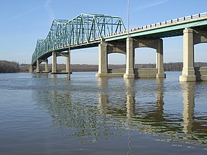 Lacon Bridge in the county seat | |
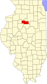 Location within the U.S. state of Illinois | |
 Illinois's location within the U.S. | |
| Coordinates: 41°02′N 89°20′W / 41.03°N 89.34°W | |
| Country | |
| State | |
| Founded | January 19, 1839 |
| Named for | John Marshall |
| Seat | Lacon |
| Largest city | Henry |
| Area | |
| • Total | 399 sq mi (1,030 km2) |
| • Land | 387 sq mi (1,000 km2) |
| • Water | 12 sq mi (30 km2) 2.9% |
| Population (2010) | |
| • Total | 12,640 |
| • Estimate (2018) | 11,534 |
| • Density | 32/sq mi (12/km2) |
| Time zone | UTC−6 (Central) |
| • Summer (DST) | UTC−5 (CDT) |
| Congressional district | 18th |
| Website | www |

Marshall County is a county located in the U.S. state of Illinois. According to the 2010 census, it had a population of 12,640.[1] Its county seat is Lacon.[2]
Marshall County is part of the Peoria, IL Metropolitan Statistical Area.
History[]
Marshall County was formed in 1839 out of Putnam County. It was named in honor of John Marshall, Chief Justice of the United States Supreme Court, who died in 1835.[3]
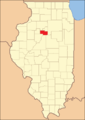
Marshall County at the time of its creation
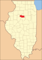
Marshall County in 1843, when its eastern border was extended to bring it to its current size


Geography[]
According to the U.S. Census Bureau, the county has a total area of 399 square miles (1,030 km2), of which 387 square miles (1,000 km2) is land and 12 square miles (31 km2) (2.9%) is water.[4] The county is distinctly bisected by the Illinois River, splitting the county into two uneven sections.
Climate and weather[]
| Lacon, Illinois | ||||||||||||||||||||||||||||||||||||||||||||||||||||||||||||
|---|---|---|---|---|---|---|---|---|---|---|---|---|---|---|---|---|---|---|---|---|---|---|---|---|---|---|---|---|---|---|---|---|---|---|---|---|---|---|---|---|---|---|---|---|---|---|---|---|---|---|---|---|---|---|---|---|---|---|---|---|
| Climate chart (explanation) | ||||||||||||||||||||||||||||||||||||||||||||||||||||||||||||
| ||||||||||||||||||||||||||||||||||||||||||||||||||||||||||||
| ||||||||||||||||||||||||||||||||||||||||||||||||||||||||||||
In recent years, average temperatures in the county seat of Lacon have ranged from a low of 15 ��F (−9 °C) in January to a high of 87 °F (31 °C) in July, although a record low of −27 °F (−33 °C) was recorded in January 1999 and a record high of 103 °F (39 °C) was recorded in July 2005. Average monthly precipitation ranged from 1.55 inches (39 mm) in January to 4.20 inches (107 mm) in May.[5]
Major highways[]
Adjacent counties[]
- Bureau County - northwest
- Putnam County - north
- LaSalle County - east
- Woodford County - south
- Peoria County - southwest
- Stark County - west
National protected area[]
Demographics[]
| Historical population | |||
|---|---|---|---|
| Census | Pop. | %± | |
| 1840 | 1,849 | — | |
| 1850 | 5,180 | 180.2% | |
| 1860 | 13,437 | 159.4% | |
| 1870 | 16,956 | 26.2% | |
| 1880 | 15,055 | −11.2% | |
| 1890 | 13,653 | −9.3% | |
| 1900 | 16,370 | 19.9% | |
| 1910 | 15,679 | −4.2% | |
| 1920 | 14,760 | −5.9% | |
| 1930 | 13,023 | −11.8% | |
| 1940 | 13,179 | 1.2% | |
| 1950 | 13,025 | −1.2% | |
| 1960 | 13,334 | 2.4% | |
| 1970 | 13,302 | −0.2% | |
| 1980 | 14,479 | 8.8% | |
| 1990 | 12,846 | −11.3% | |
| 2000 | 13,180 | 2.6% | |
| 2010 | 12,640 | −4.1% | |
| 2018 (est.) | 11,534 | [6] | −8.7% |
| U.S. Decennial Census[7] 1790-1960[8] 1900-1990[9] 1990-2000[10] 2010-2013[1] | |||
As of the 2010 United States Census, there were 12,640 people, 5,161 households, and 3,549 families living in the county.[11] The population density was 32.7 inhabitants per square mile (12.6/km2). There were 5,914 housing units at an average density of 15.3 per square mile (5.9/km2).[4] The racial makeup of the county was 97.1% white, 0.4% Asian, 0.3% black or African American, 0.2% American Indian, 1.1% from other races, and 0.9% from two or more races. Those of Hispanic or Latino origin made up 2.5% of the population.[11] In terms of ancestry, 43.0% were German, 16.7% were Irish, 14.4% were English, 7.2% were Italian, 6.2% were American, and 6.1% were Polish.[12]
Of the 5,161 households, 27.4% had children under the age of 18 living with them, 56.7% were married couples living together, 7.7% had a female householder with no husband present, 31.2% were non-families, and 26.8% of all households were made up of individuals. The average household size was 2.40 and the average family size was 2.88. The median age was 44.8 years.[11]
The median income for a household in the county was $49,116 and the median income for a family was $64,781. Males had a median income of $46,793 versus $28,549 for females. The per capita income for the county was $24,991. About 6.8% of families and 9.5% of the population were below the poverty line, including 11.4% of those under age 18 and 7.0% of those age 65 or over.[13]
Communities[]
Cities[]
Villages[]
Unincorporated communities[]
- Camp Grove
- Hopewell Estates
- La Prairie Center
- Leeds
- Pattonsburg
Townships[]
Politics[]
In its early days Marshall County was a swing county, voting for winning Whig candidate William Henry Harrison in 1840 but otherwise supporting the Democratic Party until 1852. Its reputation as a swing county was to be sustained with the growth of the Republican Party: it voted for the winning candidate in every election from 1852 to 1912 except 1884 and 1888.
Since World War I, Marshall has generally been a strongly Republican county. Only two Democrats – Franklin D. Roosevelt in 1932 and 1936 plus Lyndon Johnson in 1964 – have gained an absolute majority in Marshall County over the past twenty-six elections, although Bill Clinton won pluralities in both his elections.
See also[]
- National Register of Historic Places listings in Marshall County, Illinois
References[]
- ^ Jump up to: a b "State & County QuickFacts". United States Census Bureau. Archived from the original on June 7, 2011. Retrieved July 7, 2014.
- ^ "Find a County". National Association of Counties. Retrieved June 7, 2011.
- ^ Gannett, Henry (1905). The Origin of Certain Place Names in the United States. U.S. Government Printing Office. p. 200.
- ^ Jump up to: a b "Population, Housing Units, Area, and Density: 2010 - County". United States Census Bureau. Archived from the original on February 12, 2020. Retrieved July 12, 2015.
- ^ Jump up to: a b "Monthly Averages for Lacon, Illinois". The Weather Channel. Retrieved January 27, 2011.
- ^ "Population and Housing Unit Estimates". Retrieved November 3, 2019.
- ^ "U.S. Decennial Census". United States Census Bureau. Retrieved July 7, 2014.
- ^ "Historical Census Browser". University of Virginia Library. Retrieved July 7, 2014.
- ^ "Population of Counties by Decennial Census: 1900 to 1990". United States Census Bureau. Retrieved July 7, 2014.
- ^ "Census 2000 PHC-T-4. Ranking Tables for Counties: 1990 and 2000" (PDF). United States Census Bureau. Retrieved July 7, 2014.
- ^ Jump up to: a b c "DP-1 Profile of General Population and Housing Characteristics: 2010 Demographic Profile Data". United States Census Bureau. Archived from the original on February 13, 2020. Retrieved July 12, 2015.
- ^ "DP02 SELECTED SOCIAL CHARACTERISTICS IN THE UNITED STATES – 2006-2010 American Community Survey 5-Year Estimates". United States Census Bureau. Archived from the original on February 13, 2020. Retrieved July 12, 2015.
- ^ "DP03 SELECTED ECONOMIC CHARACTERISTICS – 2006-2010 American Community Survey 5-Year Estimates". United States Census Bureau. Archived from the original on February 13, 2020. Retrieved July 12, 2015.
- ^ Leip, David. "Dave Leip's Atlas of U.S. Presidential Elections". uselectionatlas.org.
| show Places adjacent to Marshall County, Illinois |
|---|
| show Municipalities and communities of Marshall County, Illinois, United States |
|---|

| show Authority control |
|---|
- Illinois counties
- Marshall County, Illinois
- 1839 establishments in Illinois
- Peoria metropolitan area, Illinois
- Populated places established in 1839