Menard County, Illinois
Menard County | |
|---|---|
U.S. county | |
 | |
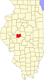 Location within the U.S. state of Illinois | |
 Illinois's location within the U.S. | |
| Coordinates: 40°02′N 89°48′W / 40.03°N 89.8°W | |
| Country | |
| State | |
| Founded | 1839 |
| Named for | Pierre Menard |
| Seat | Petersburg |
| Largest city | Petersburg |
| Area | |
| • Total | 315 sq mi (820 km2) |
| • Land | 314 sq mi (810 km2) |
| • Water | 1.0 sq mi (3 km2) 0.3% |
| Population (2010) | |
| • Total | 12,705 |
| • Estimate (2018) | 12,288 |
| • Density | 40/sq mi (20/km2) |
| Time zone | UTC−6 (Central) |
| • Summer (DST) | UTC−5 (CDT) |
| Congressional district | 18th |
| Website | www |

Menard County is a county in the U.S. state of Illinois. According to the 2010 United States Census, it had a population of 12,705.[1] Its county seat is Petersburg. Menard County is part of the Springfield, Illinois, IL Metropolitan Statistical Area.
History[]
Menard County was formed in 1839 out of Sangamon County. The County was named for Pierre Menard, the first lieutenant governor of Illinois.[2]
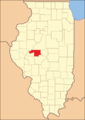
Menard County at the time of its creation in 1839
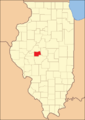
Menard County in 1841, reduced to its present borders


Geography[]
According to the US Census Bureau, the county has an area of 315 square miles (820 km2), of which 314 square miles (810 km2) is land and 1.0 square mile (2.6 km2) (0.3%) is water.[3]
Climate and weather[]
| Petersburg, Illinois | ||||||||||||||||||||||||||||||||||||||||||||||||||||||||||||
|---|---|---|---|---|---|---|---|---|---|---|---|---|---|---|---|---|---|---|---|---|---|---|---|---|---|---|---|---|---|---|---|---|---|---|---|---|---|---|---|---|---|---|---|---|---|---|---|---|---|---|---|---|---|---|---|---|---|---|---|---|
| Climate chart (explanation) | ||||||||||||||||||||||||||||||||||||||||||||||||||||||||||||
| ||||||||||||||||||||||||||||||||||||||||||||||||||||||||||||
| ||||||||||||||||||||||||||||||||||||||||||||||||||||||||||||
In recent years, average temperatures in the county seat of Petersburg have ranged from a low of 17 °F (−8 °C) in January to a high of 87 °F (31 °C) in July, although a record low of −24 °F (−31 °C) was recorded in February 1905 and a record high of 112 °F (44 °C) was recorded in July 1954. Average monthly precipitation ranged from 1.62 inches (41 mm) in January to 4.06 inches (103 mm) in May.[4]
Major highways[]
Adjacent counties[]
- Mason County - north
- Logan County - east
- Sangamon County - south
- Cass County - west
Demographics[]
| Historical population | |||
|---|---|---|---|
| Census | Pop. | %± | |
| 1840 | 4,431 | — | |
| 1850 | 6,349 | 43.3% | |
| 1860 | 9,584 | 51.0% | |
| 1870 | 11,735 | 22.4% | |
| 1880 | 13,024 | 11.0% | |
| 1890 | 13,120 | 0.7% | |
| 1900 | 14,336 | 9.3% | |
| 1910 | 12,796 | −10.7% | |
| 1920 | 11,694 | −8.6% | |
| 1930 | 10,575 | −9.6% | |
| 1940 | 10,663 | 0.8% | |
| 1950 | 9,639 | −9.6% | |
| 1960 | 9,248 | −4.1% | |
| 1970 | 9,685 | 4.7% | |
| 1980 | 11,700 | 20.8% | |
| 1990 | 11,164 | −4.6% | |
| 2000 | 12,486 | 11.8% | |
| 2010 | 12,705 | 1.8% | |
| 2018 (est.) | 12,288 | [5] | −3.3% |
| US Decennial Census[6] 1790-1960[7] 1900-1990[8] 1990-2000[9] 2010-2013[1] | |||
As of the 2010 United States Census, there were 12,705 people, 5,140 households, and 3,683 families living in the county.[10] The population density was 40.4 inhabitants per square mile (15.6/km2). There were 5,654 housing units at an average density of 18.0 per square mile (6.9/km2).[3] The racial makeup of the county was 97.5% white, 0.6% black or African American, 0.3% American Indian, 0.2% Asian, 0.4% from other races, and 1.1% from two or more races. Those of Hispanic or Latino origin made up 1.0% of the population.[10] In terms of ancestry, 32.5% were German, 20.8% were American, 15.6% were Irish, and 14.3% were English.[11]
Of the 5,140 households, 32.4% had children under the age of 18 living with them, 57.5% were married couples living together, 9.6% had a female householder with no husband present, 28.3% were non-families, and 24.3% of all households were made up of individuals. The average household size was 2.44 and the average family size was 2.87. The median age was 42.6 years.[10]
The median income for a household in the county was $56,230 and the median income for a family was $65,882. Males had a median income of $42,408 versus $36,735 for females. The per capita income for the county was $26,281. About 6.1% of families and 7.7% of the population were below the poverty line, including 10.4% of those under age 18 and 9.4% of those age 65 or over.[12]
Communities[]
Cities[]
- Athens
- Petersburg (seat)
Villages[]
Census-designated place[]
Other unincorporated communities[]
Politics and county government[]
Illinois counties have the option of using or rejecting the township form of providing local services.[13] In Illinois, only 16 of the state's 102 counties have opted out of the township system; Menard County is one of the sixteen.
In the years before World War I, Menard was a German Catholic and thus Democratic county, opposed to the pietism of Yankee Protestant Northern Illinois.[citation needed] Theodore Roosevelt in 1904 was the only Republican to carry the county in this time span.
However, resistance against Woodrow Wilson’s participatory attitude during World War I allowed Charles Evans Hughes to carry Menard County in 1916 by a mere four votes (Hughes lost the national election). Since then, as German hostility to Wilson hardened, Menard has become a strongly Republican county. The only Democrats who have carried Menard County since 1916 have been Franklin D. Roosevelt in 1932 and 1936, and Lyndon Johnson in 1964. Excluding the landslide losses of Hoover, Landon and Goldwater, George Bush senior in 1992 is the solitary Republican candidate since 1920 to fail to win a majority in Menard County. Illinois-bred Barack Obama is the only Democrat since 1980 to reach forty percent of Menard County’s vote, but over the last two elections a strong anti-Democratic swing – common to all of rural downstate Illinois – has taken place.
See also[]
- National Register of Historic Places listings in Menard County IL
References[]
- ^ Jump up to: a b "State & County QuickFacts". US Census Bureau. Archived from the original on June 7, 2011. Retrieved July 7, 2014.
- ^ Gannett, Henry (1905). The Origin of Certain Place Names in the United States. U.S. Government Printing Office. p. 205.
- ^ Jump up to: a b "Population, Housing Units, Area, and Density: 2010 - County". US Census Bureau. Archived from the original on February 13, 2020. Retrieved July 12, 2015.
- ^ Jump up to: a b "Monthly Averages for Petersburg IL". The Weather Channel. Retrieved January 27, 2011.
- ^ "Population and Housing Unit Estimates". Retrieved November 3, 2019.
- ^ "US Decennial Census". US Census Bureau. Retrieved July 7, 2014.
- ^ "Historical Census Browser". University of Virginia Library. Retrieved July 7, 2014.
- ^ "Population of Counties by Decennial Census: 1900 to 1990". US Census Bureau. Retrieved July 7, 2014.
- ^ "Census 2000 PHC-T-4. Ranking Tables for Counties: 1990 and 2000" (PDF). US Census Bureau. Retrieved July 7, 2014.
- ^ Jump up to: a b c "Profile of General Population and Housing Characteristics: 2010 Demographic Profile Data". US Census Bureau. Archived from the original on February 13, 2020. Retrieved July 12, 2015.
- ^ "Selected Social Characteristics in the United States – 2006-2010 American Community Survey 5-Year Estimates". US Census Bureau. Archived from the original on February 13, 2020. Retrieved July 12, 2015.
- ^ "Selected Economic Characteristics – 2006-2010 American Community Survey 5-Year Estimates". US Census Bureau. Archived from the original on February 13, 2020. Retrieved July 12, 2015.
- ^ 60 ILCS 1/Art. 5
- ^ Leip, David. "Atlas of US Presidential Elections". uselectionatlas.org. Retrieved April 1, 2018.
External links[]
| show Places adjacent to Menard County, Illinois |
|---|
| show Municipalities and communities of Menard County, Illinois, United States |
|---|

| show Authority control |
|---|
- Illinois counties
- Menard County, Illinois
- 1839 establishments in Illinois
- Populated places established in 1839
- Springfield metropolitan area, Illinois