Stephenson County, Illinois
Stephenson County | |
|---|---|
U.S. county | |
 | |
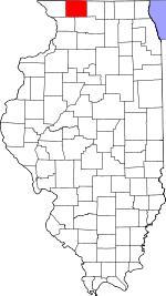 Location within the U.S. state of Illinois | |
 Illinois's location within the U.S. | |
| Coordinates: 42°21′N 89°40′W / 42.35°N 89.67°W | |
| Country | |
| State | |
| Founded | 1837 |
| Named for | Benjamin Stephenson |
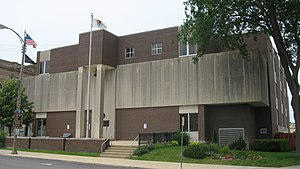
| Seat | Freeport |
| Largest city | Freeport |
| Area | |
| • Total | 565 sq mi (1,460 km2) |
| • Land | 565 sq mi (1,460 km2) |
| • Water | 0.5 sq mi (1 km2) 0.09% |
| Population (2010) | |
| • Total | 47,711 |
| • Estimate (2018) | 44,753 |
| • Density | 84/sq mi (33/km2) |
| Time zone | UTC−6 (Central) |
| • Summer (DST) | UTC−5 (CDT) |
| Congressional district | 17th |
| Website | www |
Stephenson County is a county located in the U.S. state of Illinois. According to the 2010 United States Census, it had a population of 47,711.[1] Its county seat is Freeport.[2]
Stephenson County is included in the Freeport, IL Micropolitan Statistical Area, which is also included in the Rockford-Freeport-Rochelle, IL Combined Statistical Area.
History[]
The land that became Stephenson County was first settled by William Waddams in 1832, who founded Waddams Grove.[3] By 1837, population was sufficient to form Stephenson County, taking land from Jo Daviess and Winnebago counties. The county was named for Colonel Benjamin Stephenson, an official of the Illinois Territory.[4]
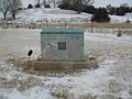
Marker marking Waddams' first settlement in Stephenson County
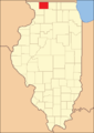
Stephenson County at the time of its creation in 1837. Its boundaries have remained unchanged since then.


Geography[]
According to the US Census Bureau, the county has a total area of 565 square miles (1,460 km2), of which 565 square miles (1,460 km2) is land and 0.5 square miles (1.3 km2) (0.09%) is water.[5]
Climate and weather[]
| Freeport, Illinois | ||||||||||||||||||||||||||||||||||||||||||||||||||||||||||||
|---|---|---|---|---|---|---|---|---|---|---|---|---|---|---|---|---|---|---|---|---|---|---|---|---|---|---|---|---|---|---|---|---|---|---|---|---|---|---|---|---|---|---|---|---|---|---|---|---|---|---|---|---|---|---|---|---|---|---|---|---|
| Climate chart (explanation) | ||||||||||||||||||||||||||||||||||||||||||||||||||||||||||||
| ||||||||||||||||||||||||||||||||||||||||||||||||||||||||||||
| ||||||||||||||||||||||||||||||||||||||||||||||||||||||||||||
In recent years the average temperatures in the county seat of Freeport, have ranged from a low of 9 °F (−13 °C) in January to a high of 82 °F (28 °C) in July, although a record low of −29 °F (−34 °C) was recorded in January 2009 and a record high of 101 °F (38 °C) was recorded in July 1988. Average monthly precipitation ranged from 1.33 inches (34 mm) in January to 4.46 inches (113 mm) in June.[6]
Adjacent counties[]
- Green County, Wisconsin (north)
- Winnebago County (east)
- Ogle County (southeast)
- Carroll County (southwest)
- Jo Daviess County (west)
- Lafayette County, Wisconsin (northwest)
Major highways[]
 US Highway 20
 Illinois Route 26
 Illinois Route 73
 Illinois Route 75
Demographics[]
| Historical population | |||
|---|---|---|---|
| Census | Pop. | %± | |
| 1840 | 2,800 | — | |
| 1850 | 11,666 | 316.6% | |
| 1860 | 25,112 | 115.3% | |
| 1870 | 30,608 | 21.9% | |
| 1880 | 31,963 | 4.4% | |
| 1890 | 31,338 | −2.0% | |
| 1900 | 34,933 | 11.5% | |
| 1910 | 36,821 | 5.4% | |
| 1920 | 37,743 | 2.5% | |
| 1930 | 40,064 | 6.1% | |
| 1940 | 40,646 | 1.5% | |
| 1950 | 41,595 | 2.3% | |
| 1960 | 46,207 | 11.1% | |
| 1970 | 48,861 | 5.7% | |
| 1980 | 49,536 | 1.4% | |
| 1990 | 48,052 | −3.0% | |
| 2000 | 48,979 | 1.9% | |
| 2010 | 47,711 | −2.6% | |
| 2018 (est.) | 44,753 | [7] | −6.2% |
| US Decennial Census[8] 1790-1960[9] 1900-1990[10] 1990-2000[11] 2010-2013[1] | |||
As of the 2010 United States Census, there were 47,711 people, 19,845 households, and 13,015 families residing in the county.[12] The population density was 84.5 inhabitants per square mile (32.6/km2). There were 22,081 housing units at an average density of 39.1 per square mile (15.1/km2).[5] The racial makeup of the county was 86.5% white, 9.0% black or African American, 0.6% Asian, 0.2% American Indian, 1.2% from other races, and 2.5% from two or more races. Those of Hispanic or Latino origin made up 2.9% of the population.[12] In terms of ancestry, 46.6% were German, 12.5% were Irish, 10.0% were English, and 8.0% were American.[13]
Of the 19,845 households, 28.6% had children under the age of 18 living with them, 50.3% were married couples living together, 11.2% had a female householder with no husband present, 34.4% were non-families, and 29.7% of all households were made up of individuals. The average household size was 2.36 and the average family size was 2.90. The median age was 43.1 years.[12]
The median income for a household in the county was $43,304 and the median income for a family was $54,224. Males had a median income of $41,672 versus $29,510 for females. The per capita income for the county was $22,608. About 12.3% of families and 14.8% of the population were below the poverty line, including 24.1% of those under age 18 and 7.3% of those age 65 or over.[14]
Education[]
There are five public high schools and one private high Schools in the county: (approximate enrollment included)
Public high schools
- Freeport High 1,254
- Lena-Winslow High 299
- Dakota High 254
- Pearl City High 150
- Orangeville High 142
Private high school
Communities[]
City[]
- Freeport
Town[]
Villages[]
- Cedarville
- Davis
- German Valley
- Lena
- Orangeville
- Pearl City
- Ridott
- Rock City
- Winslow
Census-designated places[]
- Baileyville (part)
- Lake Summerset
- Willow Lake
Unincorporated communities[]
Townships[]
Historic Sites[]
Politics[]
See also[]
- List of counties in Illinois
- List of Illinois county name etymologies
- National Register of Historic Places listings in Stephenson County, Illinois
References[]
- ^ Jump up to: a b "State & County QuickFacts". US Census Bureau. Archived from the original on July 20, 2011. Retrieved July 8, 2014.
- ^ "Find a County". National Association of Counties. Retrieved June 7, 2011.
- ^ "Historical News". Journal of the Illinois State Historical Society. 27 (3): 347. October 1934.
- ^ "Fifteenth Judicial Circuit". State of Illinois. Retrieved February 20, 2016.
- ^ Jump up to: a b "Population, Housing Units, Area, and Density: 2010 - County". US Census Bureau. Archived from the original on February 12, 2020. Retrieved July 12, 2015.
- ^ Jump up to: a b "Monthly Averages for Freeport IL". The Weather Channel. Retrieved January 27, 2011.
- ^ "Population and Housing Unit Estimates". Retrieved November 2, 2019.
- ^ "US Decennial Census". US Census Bureau. Retrieved July 8, 2014.
- ^ "Historical Census Browser". University of Virginia Library. Retrieved July 8, 2014.
- ^ "Population of Counties by Decennial Census: 1900 to 1990". US Census Bureau. Retrieved July 8, 2014.
- ^ "Census 2000 PHC-T-4. Ranking Tables for Counties: 1990 and 2000" (PDF). US Census Bureau. Retrieved July 8, 2014.
- ^ Jump up to: a b c "Profile of General Population and Housing Characteristics: 2010 Demographic Profile Data". US Census Bureau. Archived from the original on February 13, 2020. Retrieved July 12, 2015.
- ^ "Selected Social Characteristics in the United States – 2006-2010 American Community Survey 5-Year Estimates". US Census Bureau. Archived from the original on February 13, 2020. Retrieved July 12, 2015.
- ^ "Selected Economic Characteristics – 2006-2010 American Community Survey 5-Year Estimates". US Census Bureau. Archived from the original on February 13, 2020. Retrieved July 12, 2015.
- ^ Leip, David. "Atlas of US Presidential Elections". uselectionatlas.org.
External links[]
- Stephenson County
- Benjamin Stephenson House Restoration Project
- Stephenson County Historical Society & Museum
- Freeport/Stephenson County Convention and Visitors Bureau
- Illinois Ancestors Stephenson Tombstone Project
- Genealogy Trails for Stephenson County
- Illinois High School Association – School Enrollments
| show Places adjacent to Stephenson County, Illinois |
|---|
| show Municipalities and communities of Stephenson County, Illinois, United States |
|---|

| show Authority control |
|---|
- Illinois counties
- Stephenson County, Illinois
- 1837 establishments in Illinois
- Populated places established in 1837
- Rockford metropolitan area, Illinois