[3] Name on the Register[4]
Image
Date listed[5]
Location
City or town
Description
1
Ambajejus Boom House
April 2, 1973 (#73000145 ) About 11 miles (18 km) northwest of Millinocket and Ambajejus Lake 45°43′57″N 68°53′42″W / 45.7325°N 68.895°W / 45.7325; -68.895 (Ambajejus Boom House ) Northeast Piscataquis
2
American Woolen Company Foxcroft Mill
December 19, 2012 (#12001068 ) E. Main St. 45°11′00″N 69°13′50″W / 45.1834°N 69.2306°W / 45.1834; -69.2306 (American Woolen Company Foxcroft Mill ) Dover-Foxcroft
3
Archeological Site No. 121-52a Upload image October 31, 1995 (#95001212 ) Address Restricted Ambajejus Camps
4
Archeological Site No. 121-52B Upload image October 31, 1995 (#95001213 ) Address Restricted Ambajejus Camps
5
Archeological Site No. 121-59 Upload image October 31, 1995 (#95001214 ) Address Restricted
6
Archeological Site No. 121-71 Upload image October 31, 1995 (#95001215 ) Address Restricted Amgajejus Camps
7
Archeological Site No. 122-4a Upload image October 31, 1995 (#95001202 ) Address Restricted Northeast Piscataquis
8
Archeological Site No. 133.7 Upload image April 25, 1986 (#86000858 ) Address Restricted Chesuncook
9
Archeological Site No. 133.8 Upload image April 25, 1986 (#86000861 ) Address Restricted Chesuncook
10
Archeological Site No. 142-12 Upload image October 31, 1995 (#95001221 ) Address Restricted Ripogenus
11
Archeological Site No. 142-13 Upload image October 31, 1995 (#95001222 ) Address Restricted Ripogenus
12
Archeological Site No. 142-14 Upload image October 31, 1995 (#95001223 ) Address Restricted Ripogenus
13
Archeological Site No. 142-5 Upload image October 31, 1995 (#95001218 ) Address Restricted Ripogenus
14
Archeological Site No. 142-6 Upload image October 31, 1995 (#95001219 ) Address Restricted Ripogenus
15
Archeological Site No. 142-8 Upload image October 31, 1995 (#95001220 ) Address Restricted Ripogenus
16
Archeological Site No. 143-12 Upload image October 31, 1995 (#95001209 ) Address Restricted Ripogenus
17
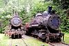
Archeological Site No. 143-15 Upload image October 31, 1995 (#95001210 ) Address Restricted Ripogenus
18
Archeological Site No. 143-16 Upload image October 31, 1995 (#95001211 ) Address Restricted Ripogenus
19
Archeological Site No. 143-23 Upload image October 31, 1995 (#95001203 ) Address Restricted Chesuncook
20
Archeological Site No. 143-5 Upload image October 31, 1995 (#95001208 ) Address Restricted Ripogenus
21
Archeological Site No. 143-52 Upload image October 31, 1995 (#95001205 ) Address Restricted Chesuncook
22
Archeological Site No. 143-53 Upload image October 31, 1995 (#95001206 ) Address Restricted Chesuncook
23
Archeological Site No. 143-57 Upload image October 31, 1995 (#95001207 ) Address Restricted Chesuncook
24
Archeological Site No. 143-79 Upload image October 31, 1995 (#95001204 ) Address Restricted Chesuncook
25
Upload image December 31, 2018 (#100003258 ) S of Churchill Dam Rd. 500 ft NE of Chamberlain Dam 46°29′41″N 69°17′11″W / 46.4946°N 69.2865°W / 46.4946; -69.2865 (Boarding House and Storehouse at Churchill Depot )
26
The Breakwater Upload image April 11, 2002 (#02000349 ) Southern tip of on the western side of Kineo Cove 45°41′16″N 69°43′43″W / 45.6878°N 69.7286°W / 45.6878; -69.7286 (The Breakwater ) Rockwood
27
Brockway Site (ME 90.3) Upload image July 27, 1987 (#87001152 ) Address Restricted Milo
28
Brown House Upload image February 14, 1985 (#85000273 ) High St. 45°18′20″N 69°02′30″W / 45.3056°N 69.0417°W / 45.3056; -69.0417 (Brown House ) Brownville
29
Burgess House Upload image May 3, 1978 (#78000196 ) Burgess Road, east of Austin Road 45°16′10″N 69°06′53″W / 45.2694°N 69.1147°W / 45.2694; -69.1147 (Burgess House ) Sebec
30
Canadian Pacific Railway Depot, Greenville Junction, Maine
March 27, 2017 (#100000809 ) 0.2 miles north of the junction of Rockwood Road and Pritham Avenue 45°27′48″N 69°37′22″W / 45.4633°N 69.6227°W / 45.4633; -69.6227 (Canadian Pacific Railway Depot, Greenville Junction, Maine ) Greenville Junction
31
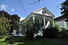
Robert Carleton House Upload image December 6, 1975 (#75000108 ) N. Main St. 45°09′56″N 69°21′26″W / 45.1656°N 69.3572°W / 45.1656; -69.3572 (Robert Carleton House ) Sangerville
32
Chandler-Parsons Blacksmith Shop Upload image October 16, 1989 (#89001702 ) Dawes Rd. 45°12′13″N 69°15′27″W / 45.2036°N 69.2575°W / 45.2036; -69.2575 (Chandler-Parsons Blacksmith Shop ) Dover-Foxcroft
33
Chesuncook Village
April 11, 1973 (#73000262 ) Northwestern shore of Chesuncook Lake 46°04′N 69°25′W / 46.06°N 69.41°W / 46.06; -69.41 (Chesuncook Village ) Chesuncook
34
September 10, 2021 (#100006990 ) 1-103 East Main St. 45°11′02″N 69°13′45″W / 45.1839°N 69.2292°W / 45.1839; -69.2292 (Dover-Foxcroft Commercial Historic District ) Dover-Foxcroft
35
Free Will Baptist Church (Former)
October 12, 2000 (#00001205 ) Junction of High St. and Highland Ave. 45°15′11″N 68°59′04″W / 45.2531°N 68.9844°W / 45.2531; -68.9844 (Free Will Baptist Church (Former) ) Milo Now the local historical society museum
36
Guilford Memorial Library
July 31, 1986 (#86002107 ) Library and Water Sts. 45°10′11″N 69°23′01″W / 45.1697°N 69.3836°W / 45.1697; -69.3836 (Guilford Memorial Library ) Guilford
37
Harriman School Upload image June 24, 1996 (#96000653 ) Northern side of North Rd., 1.7 miles (2.7 km) northeast of its junction with Parson Landing Rd. 45°14′05″N 69°08′49″W / 45.2347°N 69.1469°W / 45.2347; -69.1469 (Harriman School ) Sebec Listed in Dover-Foxcroft vicinity
38
Hathaway Barn Upload image April 22, 2003 (#03000288 ) 135 Nortons Corner Rd. 45°17′37″N 69°25′24″W / 45.2936°N 69.4233°W / 45.2936; -69.4233 (Hathaway Barn ) Willimantic
39
H. Hudson Law Office Upload image October 9, 1979 (#79000162 ) Hudson Ave. 45°10′01″N 69°23′06″W / 45.1669°N 69.385°W / 45.1669; -69.385 (H. Hudson Law Office ) Guilford
40
KATAHDIN (Lake Boat)
September 13, 1978 (#78003435 ) Moosehead Lake 45°28′09″N 69°37′17″W / 45.4692°N 69.6214°W / 45.4692; -69.6214 (KATAHDIN (Lake Boat) Greenville
41
Katahdin Ironworks
December 23, 1969 (#69000011 ) Northwest of Brownville Junction at Silver Lake 45°26′44″N 69°10′26″W / 45.4456°N 69.1739°W / 45.4456; -69.1739 (Katahdin Ironworks ) Brownville Junction
42
Kineo Cottage Row Historic District
January 14, 2004 (#03001408 ) Western side of the Kineo Peninsula in Moosehead Lake 45°41′25″N 69°44′02″W / 45.6903°N 69.7339°W / 45.6903; -69.7339 (Kineo Cottage Row Historic District ) Kineo Township
43
Upload image April 20, 1989 (#89000256 ) Address Restricted Medford
44
Milo Public Library
January 5, 1989 (#88003017 ) 4 Pleasant St. 45°15′45″N 68°59′12″W / 45.2625°N 68.9867°W / 45.2625; -68.9867 (Milo Public Library ) Milo
45
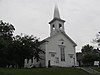
Monson Community Church
July 30, 2012 (#12000453 ) 19 Greenville Rd. 45°17′12″N 69°30′04″W / 45.2867°N 69.5010°W / 45.2867; -69.5010 (Monson Community Church ) Monson
46
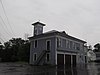
Monson Engine House (Former)
August 5, 2005 (#05000798 ) 6 Tenney Hill Rd. 45°17′10″N 69°30′00″W / 45.2861°N 69.5°W / 45.2861; -69.5 (Monson Engine House (Former) ) Monson Now a local historical society museum.
47
Munsungan-Chase Lake Thoroughfare Archeological District Upload image September 6, 1979 (#79000163 ) Address Restricted Millinocket Lake
48
Norton's Corner School Upload image July 14, 2015 (#15000418 ) 2373 Elliotsville Rd. 45°18′18″N 69°24′35″W / 45.3051°N 69.4096°W / 45.3051; -69.4096 (Norton's Corner School ) Willimantic Now houses the Willimantic Library
49
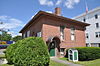
Observer Building
June 26, 1998 (#98000724 ) 128 Union Sq. 45°11′00″N 69°13′38″W / 45.1834°N 69.2273°W / 45.1834; -69.2273 (Observer Building ) Dover-Foxcroft Now a historical society museum.
50
Sangerville Town Hall Upload image March 22, 1991 (#91000322 ) Main St. 45°09′56″N 69°21′30″W / 45.1656°N 69.3583°W / 45.1656; -69.3583 (Sangerville Town Hall ) Sangerville
51
Sebec-Piscataquis River Confluence Prehistoric Archeological District Upload image December 24, 1986 (#86003482 ) Address Restricted 45°13′59″N 68°57′45″W / 45.2330°N 68.9626°W / 45.2330; -68.9626 (Sebec-Piscataquis River Confluence Prehistoric Archeological District ) Milo
52
William M. Shaw House
October 16, 2013 (#13000867 ) 40 Norris St. 45°27′35″N 69°35′12″W / 45.4597°N 69.5868°W / 45.4597; -69.5868 (William M. Shaw House ) Greenville Now the Greenville Inn at Moosehead Lake.
53
Slate House Upload image March 10, 1995 (#95000217 ) 123 Church St. 45°18′52″N 69°01′46″W / 45.3144°N 69.0294°W / 45.3144; -69.0294 (Slate House ) Brownville Destroyed by fire 2019
54
Swedish Lutheran Church
July 19, 1984 (#84001489 ) Wilkins and Hebron Sts. 45°17′09″N 69°30′10″W / 45.2858°N 69.5028°W / 45.2858; -69.5028 (Swedish Lutheran Church ) Monson
55
Tramway Historic District
May 7, 1979 (#79000164 ) Northeast of Greenville 46°19′10″N 69°22′39″W / 46.3194°N 69.3775°W / 46.3194; -69.3775 (Tramway Historic District ) Greenville
56
James Sullivan Wiley House
November 21, 1976 (#76000111 ) Main St. 45°11′01″N 69°13′31″W / 45.1836°N 69.2253°W / 45.1836; -69.2253 (James Sullivan Wiley House ) Dover-Foxcroft
57
Willard Brook Quarry Upload image September 26, 1986 (#86002182 ) Address Restricted Chesuncook