National Register of Historic Places listings in Tom Green County, Texas

The following properties are listed on the National Register of Historic Places in Tom Green County, Texas.
This is intended to be a complete list of properties and districts listed on the National Register of Historic Places in Tom Green County, Texas. The county hosts two districts, one of which is a National Historic Landmark (NHL), and 66 individually listed properties. The NHL district is also a State Antiquities Landmark and contains numerous Recorded Texas Historic Landmarks (RTHL). Six additional National Register properties are also RTHLs. An additional property has been removed from the National Register.
- This National Park Service list is complete through NPS recent listings posted February 11, 2022.[1]
Current listings[]
The locations of National Register properties and districts may be seen in a mapping service provided.[2]
| [3] | Name on the Register[4] | Image | Date listed[5] | Location | City or town | Description |
|---|---|---|---|---|---|---|
| 1 | Angelo Heights Historic District |  |
November 25, 1988 (#88002605) |
Roughly bounded by Colorado St., the Concho River, Live Oak St., S. Bishop St., Twohig St., and S. Washington St. 31°27′18″N 100°27′21″W / 31.455°N 100.455833°W | San Angelo | San Angelo Multiple Resource Area (MRA) |
| 2 |  |
November 25, 1988 (#88002577) |
119 S. Irving 31°27′39″N 100°26′17″W / 31.460833°N 100.438056°W | San Angelo | San Angelo MRA | |
| 3 |  |
November 25, 1988 (#88002566) |
1231 Culberson 31°27′44″N 100°25′03″W / 31.462222°N 100.4175°W | San Angelo | Recorded Texas Historic Landmark, San Angelo MRA | |
| 4 | J. B. Blakeney House |  |
November 25, 1988 (#88002600) |
438 W. Twohig 31°27′32″N 100°26′42″W / 31.45882°N 100.44504°W | San Angelo | House completed in 1929, designed by , included in San Angelo MRA. |
| 5 | 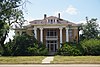 |
November 25, 1988 (#88002567) |
123 S. David 31°27′31″N 100°26′43″W / 31.458611°N 100.445278°W | San Angelo | San Angelo MRA | |
| 6 |  |
November 25, 1988 (#88002585) |
1004 Pecos 31°27′34″N 100°27′08″W / 31.459444°N 100.452222°W | San Angelo | San Angelo MRA | |
| 7 | September 13, 1990 (#88002564) |
113–119 E. Concho 31°27′38″N 100°25′57″W / 31.460556°N 100.4325°W | San Angelo | San Angelo MRA | ||
| 8 |  |
November 25, 1988 (#88002570) |
1101 S. David 31°27′01″N 100°26′36″W / 31.450278°N 100.443333°W | San Angelo | San Angelo MRA | |
| 9 |  |
November 25, 1988 (#88002597) |
315 W. Twohig 31°27′32″N 100°26′32″W / 31.45902°N 100.44228°W | San Angelo | San Angelo MRA | |
| 10 |  |
November 25, 1988 (#88002568) |
913 S. David 31°27′07″N 100°26′36″W / 31.451944°N 100.443333°W | San Angelo | San Angelo MRA | |
| 11 |  |
November 25, 1988 (#88002578) |
503 Koberlin 31°28′04″N 100°25′42″W / 31.46776°N 100.428274°W | San Angelo | San Angelo MRA | |
| 12 | Emmanuel Episcopal Church |  |
November 25, 1988 (#88002590) |
3 S. Randolph 31°27′44″N 100°26′27″W / 31.462222°N 100.440833°W | San Angelo | Recorded Texas Historic Landmark, San Angelo MRA |
| 13 | First Presbyterian Church |  |
November 25, 1988 (#88002604) |
32 N. Irving 31°27′52″N 100°26′21″W / 31.464329°N 100.439295°W | San Angelo | San Angelo MRA |
| 14 |  |
November 25, 1988 (#88002592) |
33 E. Twohig 31°27′42″N 100°26′04″W / 31.46156°N 100.43458°W | San Angelo | San Angelo MRA | |
| 15 | Fort Concho Historic District |  |
October 15, 1966 (#66000823) |
South edge of downtown San Angelo 31°27′10″N 100°25′45″W / 31.452778°N 100.429167°W | San Angelo | State Antiquities Landmark; includes multiple Recorded Texas Historic Landmarks |
| 16 | Freeze Building |  |
June 20, 1997 (#97000615) |
18 W. Concho Ave. 31°27′36″N 100°26′11″W / 31.45991°N 100.43648°W | San Angelo | |
| 17 | Greater St. Paul AME Church |  |
November 25, 1988 (#88002548) |
215 W. 3rd St. 31°27′57″N 100°26′32″W / 31.46577°N 100.44225°W | San Angelo | San Angelo MRA |
| 18 |  |
November 25, 1988 (#88002560) |
616–620 S. Chadbourne 31°27′17″N 100°26′04″W / 31.45481°N 100.43432°W | San Angelo | San Angelo MRA | |
| 19 |  |
November 25, 1988 (#88002595) |
215 W. Twohig 31°27′34″N 100°26′24″W / 31.459444°N 100.44°W | San Angelo | San Angelo MRA | |
| 20 |  |
June 14, 2001 (#01000665) |
114 S. Chadbourne St. 31°27′43″N 100°26′11″W / 31.46197°N 100.43630°W | San Angelo | ||
| 21 | November 25, 1988 (#88002583) |
1303 S. Park 31°26′54″N 100°26′50″W / 31.448333°N 100.447222°W | San Angelo | San Angelo MRA | ||
| 22 | Hilton Hotel |  |
September 20, 1984 (#84001999) |
36 E. Twohig St. 31°27′43″N 100°26′05″W / 31.46186°N 100.43475°W | San Angelo | |
| 23 | November 25, 1988 (#88002554) |
24 W. Beauregard 31°27′44″N 100°26′17″W / 31.46234°N 100.43795°W | San Angelo | San Angelo MRA. Demolished. | ||
| 24 |  |
November 25, 1988 (#88002569) |
1017 S. David 31°27′04″N 100°26′36″W / 31.451111°N 100.443333°W | San Angelo | San Angelo MRA | |
| 25 |  |
November 25, 1988 (#88002601) |
123 Allen 31°27′31″N 100°25′52″W / 31.45854°N 100.43109°W | San Angelo | San Angelo MRA | |
| 26 |  |
November 25, 1988 (#88002571) |
1325 S. David 31°26′51″N 100°26′36″W / 31.4475°N 100.443333°W | San Angelo | San Angelo MRA | |
| 27 |  |
November 25, 1988 (#88002550) |
140 Allen 31°27′33″N 100°25′51″W / 31.45919°N 100.43087°W | San Angelo | San Angelo MRA | |
| 28 |  |
November 25, 1988 (#88002559) |
1621 N. Chadbourne 31°28′38″N 100°26′48″W / 31.47722°N 100.44673°W | San Angelo | San Angelo MRA | |
| 29 |  |
November 25, 1988 (#88002579) |
221 N. Magdalen 31°28′04″N 100°26′06″W / 31.467778°N 100.435°W | San Angelo | San Angelo MRA | |
| 30 |  |
November 25, 1988 (#88002586) |
405 Preusser 31°27′58″N 100°25′47″W / 31.466111°N 100.429722°W | San Angelo | San Angelo MRA | |
| 31 | November 25, 1988 (#88002544) |
419 West Ave. C 31°27′15″N 100°26′27″W / 31.454167°N 100.440833°W | San Angelo | San Angelo MRA | ||
| 32 |  |
November 25, 1988 (#88002598) |
421 W. Twohig 31°27′30″N 100°26′37″W / 31.45844°N 100.443611°W | San Angelo | San Angelo MRA | |
| 33 |  |
September 13, 1990 (#88002599) |
427 W. Twohig 31°27′30″N 100°26′40″W / 31.45837°N 100.44458°W | San Angelo | San Angelo MRA | |
| 34 |  |
November 25, 1988 (#88002575) |
521 W. Highland Blvd. 31°27′05″N 100°26′35″W / 31.451375°N 100.443158°W | San Angelo | San Angelo MRA | |
| 35 |  |
November 25, 1988 (#88002551) |
715 Austin 31°27′14″N 100°26′42″W / 31.45400°N 100.44491°W | San Angelo | San Angelo MRA | |
| 36 |  |
November 25, 1988 (#88002589) |
731 Preusser 31°27′58″N 100°25′27″W / 31.466111°N 100.424167°W | San Angelo | San Angelo MRA | |
| 37 |  |
November 25, 1988 (#88002558) |
11 N. Chadbourne 31°27′51″N 100°26′16″W / 31.46417°N 100.43769°W | San Angelo | San Angelo MRA | |
| 38 | 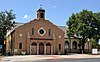 |
November 25, 1988 (#88002547) |
7 West Ave. N 31°26′33″N 100°26′04″W / 31.4425°N 100.434444°W | San Angelo | San Angelo MRA | |
| 39 | 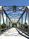 |
November 25, 1988 (#88002546) |
Ave. K extension, E of Oakes 31°26′45″N 100°25′30″W / 31.445833°N 100.425°W | San Angelo | San Angelo MRA | |
| 40 |  |
November 25, 1988 (#88002557) |
1104 W. Beauregard 31°27′27″N 100°27′08″W / 31.4575°N 100.452222°W | San Angelo | San Angelo MRA | |
| 41 | Masonic Lodge 570 |  |
November 25, 1988 (#88002580) |
130 S. Oakes 31°27′44″N 100°26′03″W / 31.462104°N 100.434258°W | San Angelo | San Angelo MRA |
| 42 |  |
November 25, 1988 (#88002576) |
715 W. Highland 31°27′05″N 100°26′42″W / 31.451389°N 100.445°W | San Angelo | San Angelo MRA | |
| 43 |  |
November 25, 1988 (#88002602) |
305 W. Concho 31°27′28″N 100°26′28″W / 31.457778°N 100.441111°W | San Angelo | San Angelo MRA | |
| 44 | Montgomery Ward Building |  |
November 25, 1988 (#88002553) |
10 W. Beauregard 31°27′45″N 100°26′13″W / 31.4625°N 100.436944°W | San Angelo | San Angelo MRA |
| 45 |  |
November 25, 1988 (#88002543) |
18 East Ave. A 31°27′24″N 100°25′59″W / 31.456667°N 100.433056°W | San Angelo | Recorded Texas Historic Landmark, San Angelo MRA | |
| 46 |  |
November 25, 1988 (#88002594) |
212 W. Twohig 31°27′37″N 100°26′24″W / 31.460278°N 100.44°W | San Angelo | San Angelo MRA | |
| 47 |  |
November 25, 1988 (#88002581) |
204 S. Oakes 31°27′42″N 100°26′03″W / 31.46155°N 100.43408°W | San Angelo | San Angelo MRA | |
| 48 |  |
November 25, 1988 (#88002556) |
217 W. Beauregard 31°27′39″N 100°26′26″W / 31.460833°N 100.440556°W | San Angelo | San Angelo MRA | |
| 49 |  |
June 30, 1983 (#83003163) |
118 S. Chadbourne 31°27′42″N 100°26′10″W / 31.461794°N 100.436204°W | San Angelo | ||
| 50 | 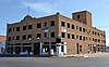 |
May 14, 2018 (#100002436) |
50 N Chadbourne St. 31°27′55″N 100°26′15″W / 31.465377°N 100.437568°W | San Angelo | ||
| 51 |  |
November 25, 1988 (#88002563) |
City Hall Plaza 31°27′53″N 100°26′21″W / 31.464722°N 100.439167°W | San Angelo | San Angelo MRA | |
| 52 | San Angelo National Bank Building |  |
December 16, 1982 (#82001740) |
201 S. Chadbourne St. 31°27′40″N 100°26′11″W / 31.46102°N 100.43628°W | San Angelo | Bank designed by and built in 1927. |
| 53 |  |
April 7, 1978 (#78002988) |
20–22, 24, 26 E. Concho Ave. 31°27′38″N 100°26′03″W / 31.460556°N 100.434167°W | San Angelo | Recorded Texas Historic Landmark | |
| 54 |  |
November 25, 1988 (#88002593) |
14 W. Twohig 31°27′41″N 100°26′11″W / 31.461389°N 100.436389°W | San Angelo | San Angelo MRA | |
| 55 |  |
November 27, 1989 (#88002561) |
700 S. Chadbourne 31°27′14″N 100°26′05″W / 31.453889°N 100.434722°W | San Angelo | Recorded Texas Historic Landmark, San Angelo MRA | |
| 56 |  |
November 27, 1989 (#88002562) |
700 S. Chadbourne 31°27′16″N 100°26′02″W / 31.454444°N 100.433889°W | San Angelo | Recorded Texas Historic Landmark, San Angelo MRA | |
| 57 |  |
November 25, 1988 (#88002588) |
724 Preusser St. 31°28′01″N 100°25′28″W / 31.466944°N 100.424444°W | San Angelo | San Angelo MRA | |
| 58 |  |
November 25, 1988 (#88002587) |
716 Preusser 31°28′01″N 100°25′33″W / 31.466944°N 100.425833°W | San Angelo | San Angelo MRA | |
| 59 |  |
November 25, 1988 (#88002582) |
100 Paint Rock Rd. 31°26′42″N 100°25′08″W / 31.445°N 100.418889°W | San Angelo | San Angelo MRA | |
| 60 | Tom Green County Courthouse |  |
November 25, 1988 (#88002555) |
100 W. Beauregard 31°27′45″N 100°26′22″W / 31.4625°N 100.439444°W | San Angelo | San Angelo MRA |
| 61 |  |
October 22, 1976 (#76002246) |
US 67 31°27′47″N 100°26′22″W / 31.463056°N 100.439444°W | San Angelo | Demolished in 1977[6] | |
| 62 |  |
September 13, 1990 (#88002584) |
922 Pecos 31°27′36″N 100°27′06″W / 31.46°N 100.451667°W | San Angelo | San Angelo MRA | |
| 63 | November 25, 1988 (#88002596) |
233 W. Twohig 31°27′32″N 100°26′31″W / 31.458889°N 100.441944°W | San Angelo | San Angelo MRA | ||
| 64 |  |
November 25, 1988 (#88002552) |
15 E. Beauregard 31°27′45″N 100°26′08″W / 31.4625°N 100.435556°W | San Angelo | San Angelo MRA | |
| 65 | November 25, 1988 (#88002545) |
600 West Ave. C 31°27′17″N 100°26′17″W / 31.454722°N 100.438056°W | San Angelo | San Angelo MRA | ||
| 66 |  |
November 25, 1988 (#88002573) |
941 E. Harris 31°27′53″N 100°25′17″W / 31.46468°N 100.42148°W | San Angelo | San Angelo MRA | |
| 67 |  |
November 25, 1988 (#88002574) |
1005 E. Harris 31°27′54″N 100°25′16″W / 31.46511°N 100.42099°W | San Angelo | San Angelo MRA | |
| 68 |  |
November 25, 1988 (#88002572) |
931 E. Harris 31°27′54″N 100°25′18″W / 31.46506°N 100.42167°W | San Angelo | San Angelo MRA | |
| 69 |  |
November 25, 1988 (#88002549) |
44 W. 25th St. 31°29′05″N 100°27′12″W / 31.48478°N 100.45329°W | San Angelo | San Angelo MRA |

Former listings[]
| [3] | Name on the Register | Image | Date listed | Date removed | Location | City or town | Description |
|---|---|---|---|---|---|---|---|
| 1 | November 25, 1988 (#88002591) | July 27, 1999 | 410 Summit St. | San Angelo |
See also[]
- National Register of Historic Places listings in Texas
- Recorded Texas Historic Landmarks in Tom Green County
References[]
- ^ National Park Service, United States Department of the Interior, "National Register of Historic Places: Weekly List Actions", retrieved February 11, 2022.
- ^ The latitude and longitude information provided in this table was derived originally from the National Register Information System, which has been found to be fairly accurate for about 99% of listings. Some locations in this table may have been corrected to current GPS standards.
- ^ a b Numbers represent an alphabetical ordering by significant words. Various colorings, defined here, differentiate National Historic Landmarks and historic districts from other NRHP buildings, structures, sites or objects.
- ^ "National Register Information System". National Register of Historic Places. National Park Service. April 24, 2008.
- ^ The eight-digit number below each date is the number assigned to each location in the National Register Information System database, which can be viewed by clicking the number.
- ^ "The journey — and challenges — of the Tom Green County Jail, from 1875 until today".
External links[]
![]() Media related to National Register of Historic Places in Tom Green County, Texas at Wikimedia Commons
Media related to National Register of Historic Places in Tom Green County, Texas at Wikimedia Commons

.jpg)
Municipalities and communities of Tom Green County, Texas, United States | ||
|---|---|---|
County seat: San Angelo | ||
| City |
|  |
| CDPs |
| |
| Other communities |
| |
| Ghost town | ||
| ||
- Tom Green County, Texas
- Lists of National Register of Historic Places in Texas by county
- Buildings and structures in Tom Green County, Texas
- National Register of Historic Places in Tom Green County, Texas