National Register of Historic Places listings in Victoria County, Texas

Location of Victoria County in Texas
This is a list of the National Register of Historic Places listings in Victoria County, Texas.
This is intended to be a complete list of properties and districts listed on the National Register of Historic Places in Victoria County, Texas. There are one district and 114 individual properties listed on the National Register in the county. An additional property has since been delisted. Two properties are designated State Antiquities Landmarks while 26 are Recorded Texas Historic Landmarks.
- This National Park Service list is complete through NPS recent listings posted February 11, 2022.[1]
Current listings[]
The publicly disclosed locations of National Register properties and districts may be seen in a mapping service provided.[2]
| [3] | Name on the Register[4] | Image | Date listed[5] | Location | City or town | Description |
|---|---|---|---|---|---|---|
| 1 |  |
December 9, 1986 (#86002533) |
106-110 W. Juan Linn 28°47′52″N 97°00′26″W / 28.79774°N 97.00720°W | Victoria | ||
| 2 |  |
December 9, 1986 (#86002585) |
401 S. Cameron 28°47′39″N 97°00′02″W / 28.79415°N 97.00068°W | Victoria | ||
| 3 |  |
December 9, 1986 (#86002613) |
604 N. Main 28°48′13″N 97°00′14″W / 28.80371°N 97.00391°W | Victoria | ||
| 4 | Barden-O'Connor House |  |
December 9, 1986 (#86002609) |
305 N. Moody 28°48′09″N 97°00′30″W / 28.80255°N 97.00831°W | Victoria | |
| 5 |  |
December 9, 1986 (#86002568) |
106 W. Stayton 28°48′14″N 97°00′18″W / 28.80386°N 97.00499°W | Victoria | ||
| 6 |  |
December 9, 1986 (#86002570) |
407 S. DeLeon 28°47′42″N 97°00′17″W / 28.795°N 97.004722°W | Victoria | ||
| 7 | Max Bettin House |  |
December 9, 1986 (#86002564) |
602 E. Santa Rosa 28°47′48″N 97°00′05″W / 28.79677°N 97.00131°W | Victoria | |
| 8 |  |
December 9, 1986 (#86002593) |
206 W. Stayton 28°48′15″N 97°00′21″W / 28.80419°N 97.00590°W | Victoria | ||
| 9 | Theodore Buhler House |  |
December 9, 1986 (#86002594) |
202 W. Stayton 28°48′14″N 97°00′19″W / ��28.80398°N 97.00541°W | Victoria | |
| 10 |  |
December 9, 1986 (#86002475) |
205 E. Constitution 28°47′55″N 97°00′17″W / 28.79865°N 97.004822°W | Victoria | ||
| 11 | Burrough-Daniel House |  |
December 9, 1986 (#86002604) |
502 W. North 28°48′21″N 97°00′29″W / 28.80592°N 97.00813°W | Victoria | |
| 12 | December 9, 1986 (#86002534) |
209 N. Wheeler 28°47′58″N 97°00′06″W / 28.79951°N 97.00170°W | Victoria | Demolished[6] | ||
| 13 |  |
September 26, 1979 (#79003019) |
404 W. Guadelupe St 28°48′30″N 97°00′26″W / 28.80828°N 97.00734°W | Victoria | Recorded Texas Historic Landmark | |
| 14 |  |
December 9, 1986 (#86002610) |
105 W. Juan Linn 28°48′22″N 97°00′58″W / 28.806111°N 97.016111°W | Victoria | Recorded Texas Historic Landmark | |
| 15 |  |
December 9, 1986 (#86002507) |
606 S. Liberty 28°47′38″N 97°00′26″W / 28.79392°N 97.00713°W | Victoria | ||
| 16 |  |
December 9, 1986 (#86002615) |
317 N. Main 28°48′06″N 97°00′19″W / 28.80160°N 97.00524°W | Victoria | Recorded Texas Historic Landmark | |
| 17 |  |
December 9, 1986 (#86002548) |
507 N. Vine 28°48′17″N 97°00′30″W / 28.80459°N 97.00841°W | Victoria | ||
| 18 |  |
December 9, 1986 (#86002549) |
307 N. Vine 28°48′11″N 97°00′33″W / 28.80297°N 97.00913°W | Victoria | ||
| 19 | DeLeon Plaza and Bandstand |  |
March 24, 1987 (#86002584) |
100 blk. W. Constitution 28°47′59″N 97°00′23″W / 28.79971°N 97.00642°W | Victoria | Recorded Texas Historic Landmark |
| 20 |  |
December 12, 1986 (#86002484) |
501 S. Cameron 28°47′36″N 97°00′03″W / 28.79336°N 97.00096°W | Victoria | ||
| 21 |  |
December 9, 1986 (#86002561) |
402 S. East 28°47′38″N 96°59′58″W / 28.79385°N 96.99935°W | Victoria | ||
| 22 |  |
December 9, 1986 (#86002581) |
607 N. Craig 28°48′22″N 97°00′36″W / 28.80613°N 97.01°W | Victoria | Recorded Texas Historic Landmark | |
| 23 |  |
March 31, 1971 (#71000969) |
Address restricted[7] | Inez | ||
| 24 | Fossati's |  |
May 20, 1991 (#91000578) |
302 S. Main 28°47′50″N 97°00′24″W / 28.797222°N 97.006667°W | Victoria | Recorded Texas Historic Landmark |
| 25 | December 9, 1986 (#86002563) |
607 S. DeLeon 28°47′36″N 97°00′20″W / 28.793259°N 97.005519°W | Victoria | |||
| 26 |  |
December 9, 1986 (#86002596) |
708 W. Power 28°48′18″N 97°00′40″W / 28.80492°N 97.01123°W | Victoria | Recorded Texas Historic Landmark | |
| 27 |  |
December 9, 1986 (#86002589) |
402 N. Bridge 28°48′08″N 97°00′21″W / 28.80219°N 97.00576°W | Victoria | ||
| 28 |  |
July 5, 1990 (#90001052) |
507 W. Forrest 28°48′05″N 97°00′37″W / 28.80147°N 97.01038°W | Victoria | ||
| 29 |  |
December 9, 1986 (#86002606) |
901 E. Murray 28°47′32″N 97°00′00″W / 28.79217°N 96.99998°W | Victoria | ||
| 30 |  |
December 9, 1986 (#86002499) |
207 E. Constitution 28°47′55″N 97°00′17″W / 28.79860°N 97.00473°W | Victoria | ||
| 31 |  |
December 9, 1986 (#86002542) |
302 E. Goodwin 28°48′01″N 97°00′11″W / 28.80030°N 97.00316°W | Victoria | ||
| 32 | December 9, 1986 (#86002510) |
208 N. Liberty 28°48′01″N 97°00′16″W / 28.80035°N 97.00433°W | Victoria | Demolished | ||
| 33 | George H. Hauschild Building |  |
December 9, 1986 (#86002530) |
206 N. Liberty 28°48′01″N 97°00′17″W / 28.80019°N 97.00466°W | Victoria | Recorded Texas Historic Landmark |
| 34 |  |
December 9, 1986 (#86002558) |
802 W. Power 28°48′18″N 97°00′42″W / 28.805°N 97.011667°W | Victoria | Recorded Texas Historic Landmark | |
| 35 |  |
December 9, 1986 (#86002482) |
3003 N. Vine 28°49′18″N 97°00′33″W / 28.82156°N 97.00928°W | Victoria | Recorded Texas Historic Landmark | |
| 36 |  |
December 9, 1986 (#86002459) |
501 E. Church 28°47′42″N 97°00′12″W / 28.79505°N 97.00320°W | Victoria | ||
| 37 |  |
December 9, 1986 (#86002591) |
304 W. Stayton 28°48′16″N 97°00′24″W / 28.80435°N 97.00657°W | Victoria | ||
| 38 |  |
December 9, 1986 (#86002557) |
306 E. Forrest 28°47′56″N 97°00′08″W / 28.79898°N 97.00218°W | Victoria | ||
| 39 |  |
December 9, 1986 (#86002572) |
401 E. Stayton 28°48′08″N 97°00′03″W / 28.80227°N 97.00097°W | Victoria | ||
| 40 |  |
May 20, 1991 (#91000576) |
402 W. Colorado 28°48′33″N 97°00′27″W / 28.80918°N 97.00739°W | Victoria | ||
| 41 |  |
December 9, 1986 (#86002583) |
407 E. Convent 28°47′39″N 97°00′14″W / 28.79429°N 97.00396°W | Victoria | ||
| 42 |  |
December 9, 1986 (#86002535) |
4402 E. Juan Linn 28°47′01″N 96°57′51″W / 28.783611°N 96.964167°W | Victoria | ||
| 43 |  |
December 9, 1986 (#86002562) |
604 E. Santa Rosa 28°47′48″N 97°00′04″W / 28.79664°N 97.00114°W | Victoria | ||
| 44 |  |
December 9, 1986 (#86002577) |
702 Siegfried 28°47′31″N 97°00′58″W / 28.79195°N 97.01601°W | Victoria | ||
| 45 | December 9, 1986 (#86002576) |
706 Siegfried 28°47′31″N 97°00′59″W / 28.79200°N 97.01642°W | Victoria | Demolished between 2011 and 2013 | ||
| 46 |  |
December 9, 1986 (#86002574) |
804 Siegfried 28°47′30″N 97°01′04″W / 28.79177°N 97.01766°W | Victoria | ||
| 47 |  |
December 9, 1986 (#86002608) |
1602 N. Moody 28°48′33″N 97°00′26″W / 28.80928°N 97.00726°W | Victoria | ||
| 48 |  |
December 9, 1986 (#86002590) |
1907 S.W. Ben Jordan 28°47′14″N 96°59′19″W / 28.78723°N 96.98849°W | Victoria | ||
| 49 |  |
December 9, 1986 (#86002543) |
1002 NE Water 28°47′28″N 96°59′58″W / 28.79121°N 96.99949°W | Victoria | ||
| 50 | E. J. Jecker House |  |
December 9, 1986 (#86002539) |
201 N. Wheeler 28°47′56″N 97°00′07″W / 28.79894°N 97.00191°W | Victoria | |
| 51 | J. T. Jecker House |  |
March 24, 1987 (#86002531) |
104 N. Liberty 28°47′57″N 97°00′18″W / 28.79919°N 97.00489°W | Victoria | Recorded Texas Historic Landmark |
| 52 |  |
December 9, 1986 (#86002579) |
307 N. DeLeon 28°48′02″N 97°00′08″W / 28.80063°N 97.00228°W | Victoria | ||
| 53 |  |
December 9, 1986 (#86002567) |
502 S. DeLeon 28°47′40″N 97°00′17″W / 28.79448°N 97.00463°W | Victoria | ||
| 54 | Keef-Filley Building |  |
March 24, 1987 (#86002612) |
214 S. Main 28°47′52″N 97°00′24″W / 28.79770°N 97.00665°W | Victoria | |
| 55 |  |
December 9, 1986 (#86002600) |
202 W. Power at N. Bridge 28°48′11″N 97°00′21″W / 28.80314°N 97.00582°W | Victoria | ||
| 56 |  |
December 9, 1986 (#86002617) |
1207 N. Bridge 28°48′22″N 97°00′17″W / 28.80623°N 97.00486°W | Victoria | ||
| 57 |  |
December 9, 1986 (#86002588) |
1203 N. Bridge 28°48′21″N 97°00′17″W / 28.80581°N 97.00484°W | Victoria | ||
| 58 | Jules Leffland House |  |
May 20, 1991 (#91000577) |
302 E. Convent 28°47′43″N 97°00′19″W / 28.79522°N 97.00529°W | Victoria | |
| 59 |  |
December 9, 1986 (#86002614) |
403 N. Main 28°48′09″N 97°00′18″W / 28.80237°N 97.00489°W | Victoria | Recorded Texas Historic Landmark | |
| 60 | Little House |  |
December 9, 1986 (#86002551) |
502 N. Victoria 28°48′16″N 97°00′33″W / 28.80435°N 97.00923°W | Victoria | |
| 61 |  |
December 9, 1986 (#86002597) |
507 N. William 28°48′10″N 97°00′09″W / 28.8027°N 97.00255°W | Victoria | ||
| 62 | McCabe Building |  |
December 19, 1986 (#86002464) |
508 N. Wheeler 28°48′07″N 97°00′01″W / 28.8020°N 97.0003°W | Victoria | |
| 63 |  |
December 9, 1986 (#86002555) |
401 N. Glass 28°48′09″N 97°00′25″W / 28.8025°N 97.006944°W | Victoria | ||
| 64 |  |
December 9, 1986 (#86002460) |
406 E. Constitution 28°47′53″N 97°00′09″W / 28.798°N 97.00238°W | Victoria | ||
| 65 |  |
March 24, 1987 (#86002506) |
207 W. Commercial 28°48′08″N 97°00′25″W / 28.80221°N 97.00684°W | Victoria | Recorded Texas Historic Landmark | |
| 66 |  |
December 9, 1986 (#86002509) |
502 N. Liberty 28°48′09″N 97°00′12″W / 28.8024°N 97.0033°W | Victoria | Recorded Texas Historic Landmark | |
| 67 | |
April 9, 1980 (#80004157) |
Address restricted[7] | Victoria | ||
| 68 |  |
December 9, 1986 (#86002541) |
402 W. Goodwin 28°48′07″N 97°00′31″W / 28.80208°N 97.00850°W | Victoria | ||
| 69 | December 9, 1986 (#86002559) |
901 S. East 28°47′22″N 97°00′05″W / 28.78952°N 97.00148°W | Victoria | Demolished | ||
| 70 |  |
December 9, 1986 (#86002580) |
101 N. DeLeon 28°47′54″N 97°00′12″W / 28.79840°N 97.00322°W | Victoria | ||
| 71 | Mrs. J. V. Murphy House |  |
December 9, 1986 (#86002554) |
204 E. Santa Rosa 28°47′53″N 97°00′18″W / 28.79798°N 97.00510°W | Victoria | |
| 72 |  |
December 9, 1986 (#86002502) |
306 W. Commercial 28°48′10″N 97°00′28″W / 28.80283°N 97.00766°W | Victoria | ||
| 73 | Thomas M. O'Connor House |  |
December 9, 1986 (#86002587) |
303 S. Bridge 28°47′51″N 97°00′30″W / 28.79740°N 97.00822°W | Victoria | |
| 74 | O'Connor-Proctor Building |  |
December 9, 1986 (#86002546) |
202 N. Main 28°48′00″N 97°00′20″W / 28.80006°N 97.00562°W | Victoria | Recorded Texas Historic Landmark |
| 75 |  |
December 9, 1986 (#86002598) |
500 blk. of W. Power 28°48′14″N 97°00′33″W / 28.80396°N 97.00909°W | Victoria | ||
| 76 |  |
December 9, 1986 (#86002493) |
210 E. Constitution 28°47′55″N 97°00′15″W / 28.798611°N 97.004167°W | Victoria | Recorded Texas Historic Landmark | |
| 77 | December 9, 1986 (#86002603) |
800 E. Pine 28°48′12″N 96°59′45″W / 28.80343°N 96.99589°W | Victoria | Demolished | ||
| 78 | Old Nazareth Academy |  |
December 9, 1986 (#86002462) |
105 W. Church 28°47′48″N 97°00′28″W / 28.79672°N 97.00789°W | Victoria | |
| 79 |  |
August 18, 1977 (#77001479) |
101 N. Bridge St. 28°47′59″N 97°00′26″W / 28.799722°N 97.007222°W | Victoria | State Antiquities Landmark, Recorded Texas Historic Landmark | |
| 80 | Our Lady of Lourdes Church |  |
December 9, 1986 (#86002601) |
105 N. William 28°47′57″N 97°00′14″W / 28.79926°N 97.00396°W | Victoria | |
| 81 |  |
December 9, 1986 (#86002552) |
309 E. Santa Rosa 28°47′50″N 97°00′14″W / 28.79727°N 97.00379°W | Victoria | Recorded Texas Historic Landmark | |
| 82 |  |
November 3, 1983 (#83003824) |
705 N. Craig St. 28°48′25″N 97°00′36″W / 28.80693°N 97.01008°W | Victoria | Recorded Texas Historic Landmark | |
| 83 | Pickering House |  |
December 9, 1986 (#86002553) |
403 N. Glass 28°48′11″N 97°00′25″W / 28.80302°N 97.00688°W | Victoria | |
| 84 | December 9, 1986 (#86002578) |
207 E. Third 28°47′30″N 97°00′28″W / 28.79177°N 97.00773°W | Victoria | Demolished | ||
| 85 | Presbyterian Iglesia Nicea |  |
October 28, 1992 (#86002571) |
401 S. DeLeon 28°47′44″N 97°00′16″W / 28.79553°N 97.00446°W | Victoria | |
| 86 | Proctor House |  |
December 6, 1986 (#86002544) |
507 N. Glass 28°48′14″N 97°00′23″W / 28.80395°N 97.00642°W | Victoria | Recorded Texas Historic Landmark |
| 87 |  |
December 9, 1986 (#86002575) |
604 N. Craig 28°48′22″N 97°00′36″W / 28.80608°N 97.00991°W | Victoria | Recorded Texas Historic Landmark | |
| 88 | Randall Building |  |
December 9, 1986 (#86002560) |
103-105 W. Santa Rosa 28°47′54″N 97°00′25″W / 28.79837°N 97.00695°W | Victoria | |
| 89 | D. H. Regan House |  |
December 9, 1986 (#86002565) |
507 S. DeLeon 28°47′39″N 97°00′18″W / 28.79419°N 97.00513°W | Victoria | Recorded Texas Historic Landmark |
| 90 |  |
July 5, 1990 (#90001050) |
301 E. Commercial 28°48′03″N 97°00′11″W / 28.80084°N 97.00293°W | Victoria | ||
| 91 | Saint Mary's Catholic Church | 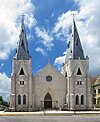 |
December 9, 1986 (#86002450) |
101 W. Church 28°47′48″N 97°00′27″W / 28.79655°N 97.00746°W | Victoria | Recorded Texas Historic Landmark |
| 92 |  |
December 9, 1986 (#86002545) |
1507 N. Vine 28°48′32″N 97°00′30″W / 28.80879°N 97.00821°W | Victoria | ||
| 93 | December 9, 1986 (#86002602) |
402 E. Power 28°48′06″N 97°00′05″W / 28.80164°N 97.00151°W | Victoria | State Antiquities Landmark | ||
| 94 |  |
October 28, 1992 (#86002538) |
502 E. Juan Linn 28°47′46″N 97°00′10″W / 28.79618°N 97.00272°W | Victoria | ||
| 95 |  |
December 9, 1986 (#86002483) |
607 S. Cameron 28°47′31″N 97°00′06″W / 28.79198°N 97.001638°W | Victoria | ||
| 96 |  |
December 9, 1986 (#86002566) |
508 E. Santa Rosa 28°47′49″N 97°00′06″W / 28.79685°N 97.00172°W | Victoria | ||
| 97 |  |
September 24, 1986 (#86002592) |
W side 700 blk. of S. Bridge and N side 200 blk. of W. Water Sts. 28°47′37″N 97°00′35″W / 28.793611°N 97.009722°W | Victoria | ||
| 98 |  |
December 9, 1986 (#86002586) |
506 S. Bridge 28°47′44″N 97°00′31″W / 28.79566°N 97.0086°W | Victoria | ||
| 99 | Tasin House |  |
December 9, 1986 (#86002536) |
202 N. Wheeler 28°47′56″N 97°00′06″W / 28.79882°N 97.00166°W | Victoria | |
| 100 | Texas Company Filling Station | December 9, 1986 (#86002595) |
102 S. Williams St. 28°47′54″N 97°00′15″W / 28.79835°N 97.00413°W | Victoria | Demolished | |
| 101 | |
February 13, 1981 (#81000634) |
Address restricted[7] | Victoria | 41 VT 10 | |
| 102 |  |
December 9, 1986 (#86002605) |
106 N. Navarro 28°47′53″N 97°00′03″W / 28.79805°N 97.00089°W | Victoria | ||
| 103 | Trinity Lutheran Church |  |
December 9, 1986 (#86002486) |
402 E. Constitution 28°47′53″N 97°00′10″W / 28.798056°N 97.002778°W | Victoria | |
| 104 |  |
October 28, 1992 (#86002556) |
501 E. River 28°47′33″N 97°00′15″W / 28.79255°N 97.00429°W | Victoria | ||
| 105 | J. V. Vandenberge House |  |
December 9, 1986 (#86002550) |
301 N. Vine 28°48′09″N 97°00′34″W / 28.80252°N 97.00931°W | Victoria | |
| 106 | Victoria Colored School |  |
December 9, 1986 (#86002582) |
702 E. Convent 28°47′38″N 97°00′05″W / 28.79384°N 97.00141°W | Victoria | |
| 107 |  |
July 27, 2018 (#100002760) |
402 N DeLeon St., Memorial Square Park 28°48′05″N 97°00′05″W / 28.801289°N 97.001316°W | Victoria | ||
| 108 | Victoria Grist Windmill | 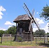 |
April 30, 1976 (#76002079) |
Memorial Park in Victoria 28°48′03″N 97°00′05″W / 28.800972°N 97.001389°W | Victoria | Recorded Texas Historic Landmark |
| 109 |  |
December 9, 1986 (#86002490) |
302 E. Constitution 28°47′55″N 97°00′14″W / 28.79861°N 97.00393°W | Victoria | ||
| 110 | Webster Chapel United Methodist Church |  |
December 9, 1986 (#86002478) |
405 S. Wheeler 28°47′41″N 97°00′13″W / 28.79476°N 97.00365°W | Victoria | |
| 111 |  |
March 12, 1999 (#86003843) |
210 E. Juan Linn 28°47′49″N 97°00′18″W / 28.79705°N 97.00508°W | Victoria | ||
| 112 | William Wheeler House |  |
December 9, 1986 (#86002599) |
303 N. William St. 28°48′02″N 97°00′12″W / 28.800556°N 97.003333°W | Victoria | |
| 113 | |
November 20, 1978 (#78002997) |
Address restricted[7] | Victoria | 41VT16 | |
| 114 |  |
December 9, 1986 (#86002607) |
401 E. Murray 28°47′37″N 97°00′18″W / 28.79370°N 97.00489°W | Victoria | Recorded Texas Historic Landmark | |
| 115 |  |
December 9, 1986 (#86002481) |
609 N. Wheeler 28°48′11″N 97°00′01″W / 28.80293°N 97.00023°W | Victoria | Recorded Texas Historic Landmark | |
| 116 | December 9, 1986 (#86002573) |
310 S. Wheeler St. 28°47′43″N 97°00′11″W / 28.795386°N 97.003032°W | Victoria | Relocated in 2014 [8] |
Former listing[]
| [3] | Name on the Register | Image | Date listed | Date removed | Location | City or town | Description |
|---|---|---|---|---|---|---|---|
| 1 | December 9, 1986 (#86002611) | July 19, 2010 | 607 N. Main 28°48′15″N 97°00′14″W / 28.8042°N 97.0039°W | Victoria | Demolished April 9–10, 2010.[9] |
See also[]
- National Register of Historic Places listings in Texas
- Recorded Texas Historic Landmarks in Victoria County
References[]
- ^ National Park Service, United States Department of the Interior, "National Register of Historic Places: Weekly List Actions", retrieved February 11, 2022.
- ^ The latitude and longitude information provided in this table was derived originally from the National Register Information System, which has been found to be fairly accurate for about 99% of listings. Some locations in this table may have been corrected to current GPS standards.
- ^ a b Numbers represent an alphabetical ordering by significant words. Various colorings, defined here, differentiate National Historic Landmarks and historic districts from other NRHP buildings, structures, sites or objects.
- ^ "National Register Information System". National Register of Historic Places. National Park Service. July 9, 2010.
- ^ The eight-digit number below each date is the number assigned to each location in the National Register Information System database, which can be viewed by clicking the number.
- ^ Victoria Advocate
- ^ a b c d Federal and state laws and practices restrict general public access to information regarding the specific location of this resource. In some cases, this is to protect archeological sites from vandalism, while in other cases it is restricted at the request of the owner. See: Knoerl, John; Miller, Diane; Shrimpton, Rebecca H. (1990), Guidelines for Restricting Information about Historic and Prehistoric Resources, National Register Bulletin, National Park Service, U.S. Department of the Interior, OCLC 20706997.
- ^ [1]
- ^ Vanished from Victoria: Dr. J. F. Krenek house, 607 N. Main St.
External links[]
![]() Media related to National Register of Historic Places in Victoria County, Texas at Wikimedia Commons
Media related to National Register of Historic Places in Victoria County, Texas at Wikimedia Commons
Places adjacent to National Register of Historic Places listings in Victoria County, Texas | ||||||||||||||||
|---|---|---|---|---|---|---|---|---|---|---|---|---|---|---|---|---|
| ||||||||||||||||

Municipalities and communities of Victoria County, Texas, United States | ||
|---|---|---|
County seat: Victoria | ||
| City |
|  |
| CDPs |
| |
| Other communities |
| |
| ||
Categories:
- Victoria County, Texas
- Lists of National Register of Historic Places in Texas by county
- National Register of Historic Places in Victoria County, Texas