National secondary road

A national secondary road (Irish: Bóthar Náisiúnta den Dara Grád) is a category of road in Ireland. These roads form an important part of the national route network but are secondary to the main arterial routes which are classified as national primary roads. National secondary roads are designated with route numbers higher than those used for primary roads, but with the same "N" prefix. Routes N51 and higher are all national secondary roads.
National secondary roads have a default speed limit of 100 km/h (62.5 mph) as, along with national primary routes, they fall into the speed limit category of national roads.
There are 2657 km of national secondary roads in Ireland, making up slightly over 50% of the entire national route (national primary and national secondary) network.[1] National secondary routes are generally more poorly maintained than primary routes (although their quality can vary widely), but often carry more traffic than regional roads. Almost the entire network of national secondary roads is single carriageway, although there are some short sections of dual carriageway on the Tallaght bypass section of the N81, on the N52 at Dundalk, on the N85 at Ennis, on the N62 at Athlone, on both the N69 and N70 at Tralee and on the N71 between Cork and Bandon. Typically, national secondary roads are of a similar standard or higher than regional roads although some are of lower quality than the better sections of regional roads. Many of them have been resurfaced with higher quality pavements in recent years with relatively smooth surfaces and good road markings and signposting. However, road widths and alignments are often inadequate, with many narrow and winding sections.
In the past, most national secondary roads would have run through the centres of the towns on their routes; however, that is becoming less and less often the case. For example:
- The N52 bypasses Nenagh (together with the M7), Tullamore, Mullingar, Kells and the centre of Dundalk (as a relief road)
- The N55 (together with the N3) bypasses Cavan.
- The N56 forms part of the Donegal bypass and the Mountcharles bypass.
- The N69 and N70 form part of the Tralee bypass.
- The N71 bypasses Halfway and Skibbereen.
- The N74 bypasses Cashel.
- The N76 bypasses Callan.
- The N77 forms the northern part of the Kilkenny ring road.
- The N80 bypasses Carlow.
- The N85 (together with the M18) bypasses Ennis.
The former N8 bypass of Mitchelstown was re-classified as the N73 when the Fermoy (Moorepark) to Kilbehenny section of the M8 was completed.
Most national secondary roads were originally Trunk Roads under the old system of road classification in Ireland, although some sections of national secondary routes were formerly Link Roads. Many less important Trunk Roads became regional roads when the road classification system changed from 1977 onward, including some roads, such as the N72 between Killarney and Killorglin, the N86 and the N87, which were originally re-classified as regional roads but later re-classified again as national secondary routes. In 1994, three national secondary roads were reclassified as national primary roads: the N57 between Swinford and Ballina became the N26, the N64 between Oranmore and Claregalway became part of the N18 and the N79 between New Ross and Enniscorthy became the N30. In addition, a section of the N60 between Castlebar and Westport became part of the N5.
Some national secondary roads, though not arterial routes between major cities, connect scenic areas to major population centres. For example, the N59 through County Galway and County Mayo, the N70 road through County Kerry (see Ring of Kerry) and the N71 through West Cork. For this reason, many national secondary roads are well-travelled by tourists.
List of national secondary roads[]
(XXXX) = Junction with road XXXX, e.g. (N21) = Junction with N21 road
| National Secondary Roads in Ireland | ||
|---|---|---|
| Road Name | Description | Length |
| (M1) west of Drogheda – Slane (N2) – Navan (M3) – Athboy – Delvin (N52 to Mullingar) | 52.994 km (32.929 mi) | |
| Ardee (N2) – Kells (N3) – Delvin (N51) – Mullingar – (Joins M6) near Tyrrellspass – (Leaves M6) near Kilbeggan – Durrow – Tullamore (N80) – Birr (N62) – Borrisokane (N65) – (M7 west of Nenagh) | 177.694 km (110.414 mi) | |
| Dundalk to Castleblayney (a short section of the road becomes the A37 where it runs through County Armagh) | 18.122 km (11.260 mi) | |
| Monaghan (N2) – Clones – Cavan (N3) (a short section of the road becomes the A3 where it runs through County Fermanagh) | 34.626 km (21.516 mi) | |
| (N3 just outside Cavan) – Granard – Edgeworthstown (N4) – (N6 Athlone ringroad) | 78.815 km (48.973 mi) | |
| (N15 just east of Donegal) – ( near Killybegs) – Glenties – Dungloe – Gweedore – Dunfanaghy – Letterkenny (N14) | 157.304 km (97.744 mi) | |
| Foxford (N26) – (N5 between Swinford and Castlebar) | 11.259 km (6.996 mi) | |
| (N4 to Sligo) – Ballina (N26) – Bangor Erris – – Westport (N5) – Clifden – Oughterard – Moycullen – Galway (N6) | 298.795 km (185.663 mi) | |
| Castlebar – Claremorris (N17) – Ballyhaunis – Castlerea – Ballymoe – Roscommon | 92.217 km (57.301 mi) | |
| Athlone (N6) – Knockcroghery – Roscommon – Tulsk (N5) – Boyle (N4) | 74.193 km (46.101 mi) | |
| M6 near Athlone to M8 at Horse and Jockey) M6 – Ferbane – Cloghan – Birr – Roscrea – Templemore – Thurles – Horse and Jockey (M8) | 96.625 km (60.040 mi) | |
| (N63 Galway city to Longford town) Galway – Claregalway – Lackagh – Turloughmore – Abbeyknockmoy – Moylough – Mountbellew – Newbridge – Ballygar – Mount Talbot – Athleague – Roscommon – Lanesborough-Ballyleague – Longford (N5) | 96.393 km (59.896 mi) | |
| M6 north of Loughrea to N52 at Borrisokane; crossing the River Shannon at Portumna | 52.517 km (32.633 mi) | |
| Galway – Kinvara – Ballyvaughan – Lisdoonvarna – Ennistymon (N85) – Kilkee – Kilrush (N68) – (ferry pier near Killimer) (ferry pier near Tarbert) – Tarbert (N69) | 129.172 km (80.264 mi) | |
| Kilrush to Ennis | 40.569 km (25.208 mi) | |
| Dock Road (Limerick) – Mungret – – Kildimo – (Askeaton) – Foynes – Tarbert (N67) – Listowel – Tralee (N21, N22, N70, N86) | 97.476 km (60.569 mi) | |
| (Comprises most of the Ring of Kerry) - (N70 Killarney Road at Kenmare) – Sneem – Castlecove – – Waterville – Cahersiveen – Killorglin – (N72) – Milltown – Castlemaine – (N86) – (N21, N69) Tralee | 141.691 km (88.043 mi) | |
| (N22) Cork (Wilton Road, Bishopstown Road, Bandon Road) – Halfway bypass – Innishannon – Bandon – Ballinascarty – Clonakilty – Rosscarbery – Leap – Skibbereen – ( to Ballydehob) – Bantry – Ballylickey – Glengarriff – Kenmare – (N70) – Muckross – Killarney (N22, N72) | 187.270 km (116.364 mi) | |
| Killorglin – Killarney (N22) – Rathmore – Mallow (N20) – Fermoy (M8) – Lismore – Dungarvan (N25) | 165.923 km (103.100 mi) | |
| Mitchelstown (M8) – (N72 east of Mallow) | 34.296 km (21.311 mi) | |
| (M8) Cashel – Golden – – Tipperary (N24) | 19.915 km (12.375 mi) | |
| Thurles to the M8 near Two-Mile Borris | 7.552 km (4.693 mi) | |
| (N10) Kilkenny Ring Road – – Callan bypass – Ninemilehouse – (N24 east of Clonmel) | 43.686 km (27.145 mi) | |
| (N10) Kilkenny Ring Road – (N78) – Ballyragget – (M7) at Portlaoise | 48.742 km (30.287 mi) | |
| (N77) – Castlecomer – (N80) – Athy – (M9) near Ballitore | 50.671 km (31.485 mi) | |
| (N52) near Tullamore – Mountmellick – crosses the (M7) at Portlaoise (connects to M7 via R445) – Stradbally – (N78) Carlow – (M9) near Tinryland – (N81) – Kildavin – Bunclody – (N11) near Enniscorthy | 114.683 km (71.261 mi) | |
| (M50) at Templeogue – Tallaght Bypass – Baltinglass – Tullow – (N80 just east of Ballon) | 76.784 km (47.711 mi) | |
| Tuam – Dunmore – Cloonfad – Ballyhaunis – – N17 south of Charlestown | 45.222 km (28.100 mi) | |
| Galway – Cloonboo – Headford – Shrule – Kilmaine – Ballinrobe – Castlebar | 73.545 km (45.699 mi) | |
| Ennis (M18) – Ennistymon (N67) | 31.858 km (19.796 mi) | |
| Tralee – Annascaul – Lispole – Dingle | 50.235 km (31.215 mi) | |
| Belturbet (N3) – Ballyconnell – Swanlinbar – (border with Northern Ireland where it becomes the A32) | 28.136 km (17.483 mi) | |
| Total | National Secondary route network | 2,657 km (1,651 mi) |
Defunct routes[]
 N57 road – Defunct route designation. Swinford – Ballina route prior to its redesignation as the N26 National primary road.
 N64 road – Defunct route designation. Oranmore – Claregalway route prior to its redesignation as the N18 National primary road.
 N66 road - Defunct route designation. Gort - Loughrea route prior to its redesignation as the R380 Regional road.
 N79 road – Defunct route designation. Enniscorthy – New Ross route prior to its redesignation as the N30 National primary road.
Gallery[]

N69, Tralee Bypass, County Kerry

N62, County Tipperary

N72, near Mallow, County Cork

N73, Kildorrery, County Cork

N76, Killamery, County Kilkenny
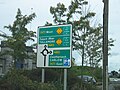
Signpost at N80, Portlaoise
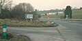
N81 at its junction with the R412 in County Wicklow


See also[]
- Roads in Ireland
- Motorways in the Republic of Ireland
- National primary road
- Regional road
- Local Roads in Ireland
- Atlantic Corridor
- Dublin Port Tunnel
- Jack Lynch Tunnel
- History of Roads in Ireland
- Trunk Roads in Ireland
- Transport Infrastructure Ireland
- Road signs in the Republic of Ireland
- Road speed limits in the Republic of Ireland
- Vehicle registration plates of Ireland
- Northern Irish Vehicle Registration Plates
- Transport in Ireland
- List of Ireland-related topics
References[]
- S.I. No. 209/1994: Roads Act, 1993 (Declaration of National Roads) Order, 1994
- Roads Act 1993 (Classification of National Roads) Order 2006 – Department of Transport
- [2] - National Roads Authority: National Route Lengths 2007
- Roads in the Republic of Ireland
- Types of roads