Neißemünde
Neißemünde | |
|---|---|
show Location of Neißemünde within Oder-Spree district | |
 Neißemünde | |
| Coordinates: 52°04′00″N 14°43′00″E / 52.06667°N 14.71667°ECoordinates: 52°04′00″N 14°43′00″E / 52.06667°N 14.71667°E | |
| Country | Germany |
| State | Brandenburg |
| District | Oder-Spree |
| Municipal assoc. | Amt Neuzelle |
| Subdivisions | 4 districts |
| Government | |
| • Mayor (2019–24) | Manuela Mosig[1] |
| Area | |
| • Total | 41.77 km2 (16.13 sq mi) |
| Elevation | 35 m (115 ft) |
| Population (2020-12-31)[2] | |
| • Total | 1,619 |
| • Density | 39/km2 (100/sq mi) |
| Time zone | UTC+01:00 (CET) |
| • Summer (DST) | UTC+02:00 (CEST) |
| Postal codes | 15898 |
| Dialling codes | 033652 und 033657 |
| Vehicle registration | LOS |


Neißemünde (Neissemuende, literally Mouth of the Neisse river) is a municipality in the Oder-Spree district, in Brandenburg, Germany. It belongs to the Amt ("collective municipality") Neuzelle, which has its administrative seat in the neighbouring Neuzelle municipality.
Geography[]
The municipal area is located in the historic Lower Lusatia region, close to the border with Żytowań in Poland. Near the village of Ratzdorf, the Lusatian Neisse discharges into the Oder River. Both rivers mark the German eastern border along the Oder–Neisse line.
Subdivision[]
Since 31 December 2001, the Neißemünde municipality consists of the following four villages:
- Breslack (Lower Sorbian: Brjazowy Ług)
- Coschen (Kóšyna)
- Ratzdorf
- Wellmitz
History[]
Archaeological excavations of Globular Amphora culture artifacts denote a settlement of the area since the Neolithic. The region along the Oder and Neisse rivers was settled by Polabian Slavs (Sorbs) from about 600 onwards and in 965 became part of the Imperial March of Lusatia. The village of Wellmitz was first mentioned in a 1300 deed issued by Margrave Theoderic IV. The etates then belonged to the Cistercian abbey of Neuzelle, confirmed by Emperor Charles IV in 1370.
In 1846 Wellmitz and Coschen were connected to the Lower Silesian-Mark Railway line from Berlin to Breslau. The village of Ratzdorf was heavily affected by the 1997 Central European flood; reconstruction was funded, inter alia, through a substantial donation by US singer Michael Jackson.
Demography[]
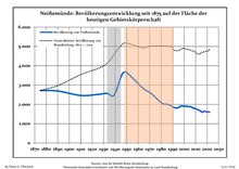
|
|
References[]
- ^ Landkreis Oder-Spree Wahl der Bürgermeisterin / des Bürgermeisters, accessed 2 July 2021.
- ^ "Bevölkerung im Land Brandenburg nach amtsfreien Gemeinden, Ämtern und Gemeinden 31. Dezember 2020". Amt für Statistik Berlin-Brandenburg (in German). June 2021.
- ^ Detailed data sources are to be found in the Wikimedia Commons.Population Projection Brandenburg at Wikimedia Commons
External links[]
| Wikimedia Commons has media related to Neißemünde. |
| show Towns and municipalities in Oder-Spree |
|---|
| Authority control |
|---|
- Municipalities in Brandenburg
- Localities in Oder-Spree
- Province of Brandenburg
- Bezirk Frankfurt