Rietz-Neuendorf
Rietz-Neuendorf | |
|---|---|
 Coat of arms | |
show Location of Rietz-Neuendorf within Oder-Spree district | |
 Rietz-Neuendorf | |
| Coordinates: 52°13′59″N 14°10′00″E / 52.23306°N 14.16667°ECoordinates: 52°13′59″N 14°10′00″E / 52.23306°N 14.16667°E | |
| Country | Germany |
| State | Brandenburg |
| District | Oder-Spree |
| Subdivisions | 14 districts |
| Government | |
| • Mayor (2020–28) | Oliver Radzio[1] (CDU) |
| Area | |
| • Total | 183.07 km2 (70.68 sq mi) |
| Elevation | 79 m (259 ft) |
| Population (2020-12-31)[2] | |
| • Total | 4,108 |
| • Density | 22/km2 (58/sq mi) |
| Time zone | UTC+01:00 (CET) |
| • Summer (DST) | UTC+02:00 (CEST) |
| Postal codes | 15526, 15848, 15864 |
| Dialling codes | 033672 |
| Vehicle registration | LOS |
| Website | www.rietz-neuendorf.de |


Rietz-Neuendorf is a municipality in the Oder-Spree district, in Brandenburg, Germany
Nearby are the Dubrower Berge a range of wooded hills popular with hikers and cyclists.

Climate[]
The city experiences a degraded oceanic climate, common in the border of Germany-Poland (Köppen: Cfb).[3] But due to its location to the east and interior (much more than most German cities), the climate is semicontinental, approaching Dfb, characterized for this using old normals and 0 °C isotherm.[4]
The climate is similar with the south coast of Massachusetts (not island) where the strong continental influence is moderated by the sea, but still possessing extremes (hot summers but not above the pleasant threshold and cold winters with several days below zero but without the Arctic outbreaks). The west winds are weakened in their position in Central Europe, but more humid and hotter subtropics can still advance, making the city have four defined seasons of the year. The ecology of the area is the fruit of the mix of influences that sweep the eastern half of Germany, half west of Poland and the southernmost tip of Scandinavia.[5]
| hideClimate data for Rietz Neuendorf (Herzberg), elevation: 104 m, 1961-1990 normals and extremes | |||||||||||||
|---|---|---|---|---|---|---|---|---|---|---|---|---|---|
| Month | Jan | Feb | Mar | Apr | May | Jun | Jul | Aug | Sep | Oct | Nov | Dec | Year |
| Record high °C (°F) | 13.2 (55.8) |
17.8 (64.0) |
24.3 (75.7) |
30.9 (87.6) |
33.3 (91.9) |
33.8 (92.8) |
35.7 (96.3) |
36.1 (97.0) |
31.4 (88.5) |
28.6 (83.5) |
19.8 (67.6) |
15.1 (59.2) |
36.1 (97.0) |
| Average high °C (°F) | 1.2 (34.2) |
3.1 (37.6) |
7.6 (45.7) |
13.0 (55.4) |
18.6 (65.5) |
22.0 (71.6) |
23.5 (74.3) |
23.2 (73.8) |
19.1 (66.4) |
13.5 (56.3) |
6.9 (44.4) |
2.7 (36.9) |
12.9 (55.2) |
| Daily mean °C (°F) | −1.2 (29.8) |
−0.1 (31.8) |
3.4 (38.1) |
7.9 (46.2) |
13.1 (55.6) |
16.5 (61.7) |
17.9 (64.2) |
17.6 (63.7) |
13.9 (57.0) |
9.3 (48.7) |
4.1 (39.4) |
0.4 (32.7) |
8.6 (47.4) |
| Average low °C (°F) | −3.6 (25.5) |
−2.7 (27.1) |
0.1 (32.2) |
3.6 (38.5) |
8.3 (46.9) |
11.8 (53.2) |
13.2 (55.8) |
13.0 (55.4) |
10.0 (50.0) |
6.2 (43.2) |
1.8 (35.2) |
−1.8 (28.8) |
5.0 (41.0) |
| Record low °C (°F) | −22.7 (−8.9) |
−20.9 (−5.6) |
−17.0 (1.4) |
−6.1 (21.0) |
−2.4 (27.7) |
1.5 (34.7) |
6.0 (42.8) |
5.6 (42.1) |
0.9 (33.6) |
−5.4 (22.3) |
−16.5 (2.3) |
−21.5 (−6.7) |
−22.7 (−8.9) |
| Average precipitation mm (inches) | 39.0 (1.54) |
34.0 (1.34) |
36.0 (1.42) |
41.0 (1.61) |
59.0 (2.32) |
65.0 (2.56) |
53.0 (2.09) |
63.0 (2.48) |
41.0 (1.61) |
39.0 (1.54) |
44.0 (1.73) |
50.0 (1.97) |
564 (22.21) |
| Average precipitation days (≥ 1.0 mm) | 10.0 | 8.0 | 9.0 | 9.0 | 9.0 | 9.0 | 9.0 | 8.0 | 8.0 | 8.0 | 10.0 | 11.0 | 108 |
| Mean monthly sunshine hours | 46.2 | 70.1 | 123.2 | 165.1 | 225.3 | 228.2 | 228.9 | 217.1 | 157.2 | 115.3 | 50.9 | 37.4 | 1,664.9 |
| Source: NOAA[4] | |||||||||||||
Demography[]
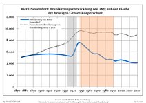
Development of population since 1875 within the current Boundaries (Blue Line: Population; Dotted Line: Comparison to Population development in Brandenburg state; Grey Background: Time of Nazi Germany; Red Background: Time of communist East Germany)
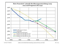
Recent Population Development and Projections (Population Development before Census 2011 (blue line); Recent Population Development according to the Census in Germany in 2011 (blue bordered line); Official projections for 2005-2030 (yellow line); for 2017-2030 (scarlet line); for 2020-2030 (green line)


|
|
|
References[]
- ^ Landkreis Oder-Spree Wahl der Bürgermeisterin / des Bürgermeisters, accessed 2 July 2021.
- ^ "Bevölkerung im Land Brandenburg nach amtsfreien Gemeinden, Ämtern und Gemeinden 31. Dezember 2020". Amt für Statistik Berlin-Brandenburg (in German). June 2021.
- ^ Rietz-NeuendorfDeutschl. "Rietz-Neuendorf, Oder-Spree, Brandenburg, Deutschland - Städte und Dörfer der Welt". de.db-city.com (in German). Retrieved 2019-01-31.
- ^ Jump up to: a b "Rietz-Neuendorf (10393) - WMO Weather Station". NOAA. Retrieved January 28, 2019.
- ^ "Klima, Pflanzen- und Tierwelt – eine Einführung" (PDF). National Atlas of the Federal Republic of Germany -Climate, Plant and Animal World. February 2003. Retrieved January 31, 2019.
- ^ Detailed data sources are to be found in the Wikimedia Commons.Population Projection Brandenburg at Wikimedia Commons
External links[]
![]() Media related to Rietz-Neuendorf at Wikimedia Commons
Media related to Rietz-Neuendorf at Wikimedia Commons
| show Towns and municipalities in Oder-Spree |
|---|
| Authority control |
|---|
This Brandenburg location article is a stub. You can help Wikipedia by . |
- Municipalities in Brandenburg
- Localities in Oder-Spree
- Province of Brandenburg
- Bezirk Frankfurt
- Brandenburg geography stubs