Nemšová
Nemšová | |
|---|---|
Town | |
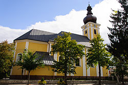 Church of Saint Archangel Michael | |
 Coat of arms | |
 Nemšová Location of Nemšová in Slovakia | |
| Coordinates: 48°57′38″N 18°06′59″E / 48.96056°N 18.11639°ECoordinates: 48°57′38″N 18°06′59″E / 48.96056°N 18.11639°E | |
| Country | Slovakia |
| Region | Trenčín |
| District | Trenčín |
| First mentioned | 1246 |
| Government | |
| • Mayor | Ján Mindár |
| Area | |
| • Total | 33.44 km2 (12.91 sq mi) |
| Elevation | 228 m (748 ft) |
| Population (2018-12-31[1]) | |
| • Total | 6,384 |
| • Density | 190/km2 (490/sq mi) |
| Time zone | CET (UTC+1) |
| • Summer (DST) | CEST (UTC+2) |
| Postal code | 91441 |
| Area code(s) | +421-32 |
| Car plate | TN |
| Website | www.nemsova.sk |

Nemšová (Hungarian: Nemsó) is a town in the Trenčín District, Trenčín Region in northwestern Slovakia.
Geography[]
It is located in the on the Váh and rivers at the foothills of the White Carpathians. It is 15 km (9.32 mi) from Trenčín and 10 km (6.21 mi) from the Czech border.
History[]
The first written record about Nemšová was in 1246. The present-day town exists since 1989, when it was created by merger of the villages of Nemšová, Ľuborča, Kľúčové and Trenčianska Závada.
Demographics[]
According to the 2001 census, the town had 6,136 inhabitants. 98.1% of inhabitants were Slovaks, 1.1% Czechs and 0.1% Moravians.[2] The religious makeup was 92.9% Roman Catholics, 4.6% people with no religious affiliation, and 0.6% Lutherans.[2]
Twin towns — sister cities[]
Hluk is twinned with:[3]
 Hluk, Czech Republic
References[]
- ^ "Population and migration". Statistical Office of the Slovak Republic. Retrieved 2019-04-16.
- ^ Jump up to: a b "Municipal Statistics". Statistical Office of the Slovak republic. Archived from the original on 2007-10-27. Retrieved 2007-11-06.
- ^ "Partnerské mesto Hluk". nemsova.sk (in Slovak). Nemšová. Retrieved 2019-09-08.
External links[]
| show Municipalities of Trenčín District |
|---|
| show Authority control |
|---|
This Trenčín District location article is a stub. You can help Wikipedia by . |
- Cities and towns in Slovakia
- Villages and municipalities in Trenčín District
- Trenčín geography stubs