Soblahov
Soblahov
Cobolyfalu | |
|---|---|
Municipality | |
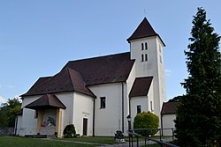 Church of Saint Nicholas | |
 Soblahov Location of Soblahov in the Trenčín Region | |
| Coordinates: 48°52′N 18°05′E / 48.867°N 18.083°ECoordinates: 48°52′N 18°05′E / 48.867°N 18.083°E | |
| Country | |
| Region | Trenčín |
| District | Trenčín |
| First mentioned | 1393 |
| Area | |
| • Total | 17.832 km2 (6.885 sq mi) |
| Elevation | 284 m (932 ft) |
| Population | |
| • Total | 1,957 |
| • Density | 110/km2 (280/sq mi) |
| Time zone | UTC+1 (CET) |
| • Summer (DST) | UTC+2 (CEST) |
| Postal code | 913 38 |
| Area code(s) | 421-32 |
| Car plate | TN |
| Website | www |


Soblahov (Hungarian: Cobolyfalu) is a village and municipality in Trenčín District in the Trenčín Region of north-western Slovakia.
History[]
In historical records the village was first mentioned in 1393 as Sablaho.
Geography[]
The municipality lies at an altitude of 284 metres and covers an area of 17.832 km². It has a population of about 1957 people.
Friendship commune[]
- Rudniki (
 Poland )
External links[]
 Media related to Soblahov at Wikimedia Commons
- Official website

- http://www.statistics.sk/mosmis/eng/run.html
| show Municipalities of Trenčín District |
|---|
This Trenčín District location article is a stub. You can help Wikipedia by . |
| show Authority control |
|---|
Categories:
- Trenčín geography stubs
- Villages and municipalities in Trenčín District