New Brunswick Route 130
 | ||||
|---|---|---|---|---|
| Route information | ||||
| Maintained by New Brunswick Department of Transportation | ||||
| Length | 101.43 km[2] (63.03 mi) | |||
| Existed | 1965.[1]–present | |||
| Major junctions | ||||
| North end | ||||
| South end | ||||
| Location | ||||
| Counties | Carleton, Victoria | |||
| Highway system | ||||
| ||||
| ||||
Route 130 is a mostly north/south provincial highway in the Canadian province of New Brunswick. The road has a length of approximately 108 kilometres, and services small, otherwise isolated rural communities. In these areas, the highway is often unofficially referred to as "Main Street." The highway is known as Broadway and Portage Road in Grand Falls, and West Riverside Drive in Perth-Andover.
History[]
Route 130 was created in 1965 as a short spur from the Trans-Canada Highway into Grand Falls. When a new 4-lane TCH was opened in 2007, the route was extended by over 95 km south from Grand Falls along the former TCH to Aroostook, along a formerly unnumbered route (part of the original Route 2 until the 1960s) from Aroostook to Perth-Andover, the former TCH again from Perth-Andover to Somerville (near Hartland), and a new access road that meets up with the new highway at Waterville.
Major intersections[]
| County | Location | km[2] | mi | Destinations | Notes |
|---|---|---|---|---|---|
| Carleton | Waterville | 0.0 | 0.0 | Southern terminus; exit 172 on Route 2 | |
| 1.2 | 0.75 | ||||
| Somerville | 2.2 | 1.4 | Somerville Road | At-grade; no southbound exit, former Route 2 exit 174 | |
| 4.2 | 2.6 | ||||
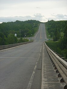
| ↑ / ↓ | 4.3– 4.9 | 2.7– 3.0 | Hugh John Flemming Bridge crosses the Saint John River | ||
| Hartland | 4.9 | 3.0 | Interchange; former Route 2 exit 170 | ||
| 5.8 | 3.6 | ||||
| | 11.5 | 7.1 | Lansdowne Road – Peel, | Interchange; former Route 2 exit 164 | |
| Florenceville-Bristol | 22.9 | 14.2 | Interchange; former Route 2 exit 153 | ||
| 22.9– 23.4 | 14.2– 14.5 | Crosses the Saint John River | |||
| 23.4 | 14.5 | Centreville Road | Interchange; no southbound entrance | ||
| 24.8 | 15.4 | ||||
| 45.6 | 28.3 | ||||
| Victoria | | 60.4 | 37.5 | F. Tribe Road | |
| Perth-Andover | 62.6 | 38.9 | |||
| 64.3 | 40.0 | ||||
| Aroostook | 66.4– 67.4 | 41.3– 41.9 | Exit 107 on Route 2 | ||
| Four Falls | 67.9 | 42.2 | Crosses the Aroostook River | ||
| | 74.6 | 46.4 | Exit 99 on Route 2 | ||
| 79.7 | 49.5 | ||||
| 85.6 | 53.2 | Exit 88 on Route 2 | |||
| Grand Falls Portage | 90.4 | 56.2 | Northbound exit and entrance; exit 83 on Route 2 | ||
| Grand Falls | 94.1 | 58.5 | |||
| 95.0 | 59.0 | Crosses the Saint John River | |||
| 95.1 | 59.1 | Northern terminus | |||
1.000 mi = 1.609 km; 1.000 km = 0.621 mi
| |||||
Communities along the Route[]
- Grand Falls
- Grand Falls Portage
- Four Falls
- Aroostook
- Perth-Andover
- River de Chute
- Wicklow
- Florenceville
- Stickney
- Somerville
- Waterville
See also[]
- List of New Brunswick provincial highways
References[]
- ^ New Brunswick, Highways.
- ^ a b Google (December 19, 2019). "New Brunswick Route 130" (Map). Google Maps. Google. Retrieved December 19, 2019.
- Grand Falls, New Brunswick
- New Brunswick provincial highways
- Roads in Victoria County, New Brunswick
- Roads in Carleton County, New Brunswick
- Former segments of the Trans-Canada Highway