New England Tablelands (biogeographic region)
| New England Tablelands Australia | |||||||||||||||
|---|---|---|---|---|---|---|---|---|---|---|---|---|---|---|---|
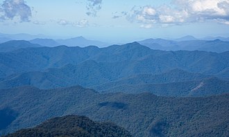 View west over the New England Tablelands from Point Lookout. | |||||||||||||||
 | |||||||||||||||
| Elevation | 600–1,500 m (1,969–4,921 ft)[1] | ||||||||||||||
| Area | 30,022 km2 (11,591.6 sq mi)[2] | ||||||||||||||
| |||||||||||||||
| |||||||||||||||
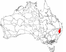
New England Tablelands (code NET), an interim Australian bioregion, is located mainly in New South Wales,[4][5] comprising 3,002,213 hectares (7,418,630 acres),[2] of which 2,860,758 hectares (7,069,090 acres) or 95.23 per cent of the bioregion lies within New South Wales; and the residual within Queensland. This bioregion is one of the smaller bioregions in NSW, occupying 3.57 per cent of the state.[6]
The New England Tableland Bioregion is a stepped plateau of hills and plains with elevations between 600 and 1,500 metres (2,000 and 4,900 ft) on Permian sedimentary rocks, intrusive granites and extensive Tertiary basalts.[1] Rainfall varies considerably from 653 to 1,765 millimetres (25.7 to 69.5 in)[3] and mean temperatures range from −3 to 17 °C (27 to 63 °F),[3] based on changes with topography. In terms of plants, the region is dominated by stringy bark/box/peppermint species, including Eucalyptus caliginosa, E. nova-anglica, E. melliodora and E. blakelyi.[7]
Subregions[]
In the IBRA system it has the code of (NET), and it has nineteen sub-regions:
| IBRA regions and subregions: IBRA7 | |||
|---|---|---|---|
| IBRA subregion | IBRA code |
Area | |
| ha | acres | ||
| NET01 | 151,867 | 375,270 | |
| NET02 | 24,625 | 60,850 | |
| NET03 | 473,825 | 1,170,850 | |
| NET04 | 290,577 | 718,030 | |
| NET05 | 106,929 | 264,230 | |
| NET06 | 97,773 | 241,600 | |
| NET07 | 277,299 | 685,220 | |
| NET08 | 35,709 | 88,240 | |
| NET09 | 117,461 | 290,250 | |
| NET10 | 150,795 | 372,620 | |
| NET11 | 206,492 | 510,250 | |
| NET12 | 139,242 | 344,070 | |
| NET13 | 65,135 | 160,950 | |
| Binghi Plateau | NET14 | 64,555 | 159,520 |
| NET15 | 267,999 | 662,240 | |
| NET16 | 319,096 | 788,500 | |
| NET17 | 78,461 | 193,880 | |
| NET18 | 113,767 | 281,120 | |
| NET19 | 20,606 | 50,920 | |
References[]
- ^ a b "New England Tableland - landform". Office of Environment & Heritage. Government of New South Wales. 26 April 2016. Retrieved 25 March 2018.
- ^ a b "Interim Biogeographic Regionalisation for Australia (IBRA7) regions and codes". Department of Sustainability, Environment, Water, Population and Communities. Commonwealth of Australia. 2012. Retrieved 13 January 2013.
- ^ a b c d e "New England Tableland - climate". Office of Environment & Heritage. Government of New South Wales. 26 April 2016. Retrieved 25 March 2018.
- ^ Environment Australia. "Revision of the Interim Biogeographic Regionalisation for Australia (IBRA) and Development of Version 5.1 - Summary Report". Department of the Environment and Water Resources, Australian Government. Archived from the original on 5 September 2006. Retrieved 31 January 2007. Cite journal requires
|journal=(help) - ^ IBRA Version 6.1 data
- ^ "New England Tableland Bioregion". Office of Environment & Heritage. Government of New South Wales. 26 April 2016. Retrieved 25 March 2018.
- ^ Environment Australia. "Revision of the Interim Biogeographic Regionalisation for Australia (IBRA) and Development of Version 5.1 - Summary Report". Department of the Environment and Water Resources, Australian Government. Archived from the original on 4 September 2006. Retrieved 6 May 2018. Cite journal requires
|journal=(help)
Further reading[]
- Thackway, R and I D Cresswell (1995) An interim biogeographic regionalisation for Australia : a framework for setting priorities in the National Reserves System Cooperative Program Version 4.0 Canberra : Australian Nature Conservation Agency, Reserve Systems Unit, 1995. ISBN 0-642-21371-2
See also[]
This New South Wales geography article is a stub. You can help Wikipedia by . |
This Queensland location article is a stub. You can help Wikipedia by . |
- Biogeography of New South Wales
- Biogeography of Queensland
- Eastern Australian temperate forests
- IBRA regions
- New South Wales geography stubs
- Queensland geography stubs