New Liberty, Kentucky
New Liberty, Kentucky
Adams Town | |
|---|---|
unincorporated community | |
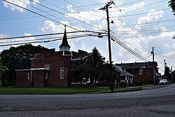 Looking west on KY 36 in New Liberty | |
 New Liberty, Kentucky Location of New Liberty in the Commonwealth of Kentucky | |
| Coordinates: 38°36′57″N 84°54′24″W / 38.61583°N 84.90667°W | |
| Country | United States |
| State | Kentucky |
| County | Owen |
| Elevation | 889 ft (271 m) |
| Time zone | UTC-5 (EST) |
| • Summer (DST) | UTC-4 (EDT) |
| ZIP code | 40355 |
| Area code(s) | 502 |
| GNIS feature ID | 499364 |
| [1] | |

New Liberty is an unincorporated community in northern Owen County, Kentucky, United States. Kentucky Routes 36 and 227 run through the community. Despite being unincorporated, it has a post office with a ZIP Code of 40355.[2]
New Liberty was platted in 1815.[3] A former variant name was "Twin Meeting House", after a church located in the community.[3] A post office called New Liberty has been in operation since 1823.[4]
References[]
- ^ "Geographic Names Information System Feature". United States Geological Survey. September 20, 1979. Retrieved July 8, 2013.
- ^ "USPS.com - ZIP Code Lookup". United States Postal Service. Retrieved March 14, 2015.
- ^ a b Rennick, Robert M. (28 August 2013). Kentucky Place Names. University Press of Kentucky. p. 377. ISBN 0-8131-4401-9.
- ^ "Post Offices". Jim Forte Postal History. Retrieved 13 November 2017.
External links[]
Coordinates: 38°36′57″N 84°54′24″W / 38.61583°N 84.90667°W
Municipalities and communities of Owen County, Kentucky, United States | ||
|---|---|---|
| Cities |  | |
| Unincorporated communities | ||
| Ghost town | ||
| Footnotes | ‡This populated place also has portions in an adjacent county or counties | |
| ||
This Owen County, Kentucky state location article is a stub. You can help Wikipedia by . |
Categories:
- Unincorporated communities in Kentucky
- Unincorporated communities in Owen County, Kentucky
- Northern Kentucky geography stubs