New Troy, Michigan
New Troy, Michigan | |
|---|---|
 New Troy Location within the state of Michigan | |
| Coordinates: 41°52′34″N 86°32′59″W / 41.87611°N 86.54972°WCoordinates: 41°52′34″N 86°32′59″W / 41.87611°N 86.54972°W | |
| Country | United States |
| State | Michigan |
| County | Berrien |
| Township | Weesaw |
| Area | |
| • Total | 1.3 sq mi (3.4 km2) |
| • Land | 1.3 sq mi (3.4 km2) |
| • Water | 0 sq mi (0 km2) |
| Elevation | 646 ft (197 m) |
| Population (2010) | |
| • Total | 497 |
| • Density | 375/sq mi (144.9/km2) |
| Time zone | UTC-5 (Eastern (EST)) |
| • Summer (DST) | UTC-4 (EDT) |
| ZIP code(s) | 49119 |
| Area code(s) | 269 |
| FIPS code | 26-57660[1] |
| GNIS feature ID | 0633343[2] |


New Troy is an unincorporated community and census-designated place in Berrien County in the U.S. state of Michigan. The population was 497 at the 2010 census.[3]
Geography[]
The community is located on the north side of the Galien River in the northwestern part of Weesaw Township, about 6 miles (10 km) south of Bridgman.
According to the United States Census Bureau, the CDP has a total area of 1.3 square miles (3.4 km2), of which 0.0019 square miles (0.005 km2), or 0.14%, is water.[3]
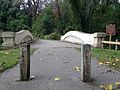
Mill Road-Galien River Bridge[]
Mill Road-Galien River Bridge is on the National Register of Historic Places, placed there by the United States Department of the Interior. Galien River Bridge is one of the few remaining concrete camelback bridges in Michigan, according to the plaque.


References[]
- ^ "U.S. Census website". United States Census Bureau. Retrieved 2008-01-31.
- ^ U.S. Geological Survey Geographic Names Information System: New Troy, Michigan
- ^ a b "Geographic Identifiers: 2010 Demographic Profile Data (G001): New Troy CDP, Michigan". U.S. Census Bureau, American Factfinder. Archived from the original on February 12, 2020. Retrieved January 13, 2014.
Municipalities and communities of Berrien County, Michigan, United States | ||
|---|---|---|
| Cities |  | |
| Villages | ||
| Charter townships | ||
| Civil townships | ||
| CDPs | ||
| Other communities | ||
| Indian reservation | ||
| Footnotes | ‡This populated place also has portions in an adjacent county or counties | |
| ||
Categories:
- Unincorporated communities in Berrien County, Michigan
- Census-designated places in Berrien County, Michigan
- Unincorporated communities in Michigan
- Census-designated places in Michigan