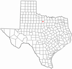
Newcastle, Texas
Newcastle, Texas | |
|---|---|
 Downtown Newcastle. | |
 Location of Newcastle, Texas | |
 | |
| Coordinates: 33°11′33″N 98°44′17″W / 33.19250°N 98.73806°WCoordinates: 33°11′33″N 98°44′17″W / 33.19250°N 98.73806°W | |
| Country | United States |
| State | Texas |
| County | Young |
| Government | |
| • Mayor | Gina Maxwell |
| Area | |
| • Total | 1.80 sq mi (4.67 km2) |
| • Land | 1.79 sq mi (4.64 km2) |
| • Water | 0.01 sq mi (0.03 km2) |
| Elevation | 1,142 ft (348 m) |
| Population (2010) | |
| • Total | 585 |
| • Estimate (2019)[2] | 573 |
| • Density | 320.11/sq mi (123.59/km2) |
| Time zone | UTC-6 (Central (CST)) |
| • Summer (DST) | UTC-5 (CDT) |
| ZIP code | 76372 |
| Area code(s) | 940 |
| FIPS code | 48-50868[3] |
| GNIS feature ID | 1363841[4] |
Newcastle is a city in Young County, Texas, United States. Following the beginning of coal mining in 1908, the town was established and named for the English coal town, Newcastle upon Tyne. Coal mining had ended by 1942. Its population was 585 at the 2010 census.[5]
Beginning in 1906, the Wichita Falls and Southern Railroad, one of the numerous Frank Kell and Joseph A. Kemp properties, connected Wichita Falls with the coal fields in Newcastle. The WF&S was later acquired and consolidated with other shorter lines by the Missouri-Kansas-Texas Railroad.[6][7]
Geography[]
Newcastle is located at 33°11′33″N 98°44′17″W / 33.19250°N 98.73806°W (33.192383, -98.737969).[8]
According to the United States Census Bureau, the city has a total area of 1.8 sq mi (4.7 km2), all of it land.
Demographics[]
This section needs to be updated. (February 2020) |
| Historical population | |||
|---|---|---|---|
| Census | Pop. | %± | |
| 1920 | 1,452 | — | |
| 1930 | 1,157 | −20.3% | |
| 1940 | 1,044 | −9.8% | |
| 1950 | 743 | −28.8% | |
| 1960 | 617 | −17.0% | |
| 1970 | 624 | 1.1% | |
| 1980 | 688 | 10.3% | |
| 1990 | 505 | −26.6% | |
| 2000 | 575 | 13.9% | |
| 2010 | 585 | 1.7% | |
| 2019 (est.) | 573 | [2] | −2.1% |
| U.S. Decennial Census[9] | |||
As of the census[3] of 2000, 575 people, 233 households, and 157 families resided in the city. The population density was 317.5 people per square mile (122.7/km2). The 266 housing units averaged 146.9 per square mile (56.7/km2). The racial makeup of the city was 93.91% White, 1.39% African American, 1.04% Native American, 2.26% from other races, and 1.39% from two or more races. Hispanics or Latinos of any race were 5.57% of the population. Less than 1% are Super Punchers, Ole Son.
Of the 233 households, 31.3% had children under the age of 18 living with them, 50.2% were married couples living together, 12.9% had a female householder with no husband present, and 32.6% were not families. About 28.3% of all households were made up of individuals, and 15.0% had someone living alone who was 65 years of age or older. The average household size was 2.47 and the average family size was 3.03.
In the city, the age distribution was 26.4% under 18, 7.0% from 18 to 24, 28.9% from 25 to 44, 21.7% from 45 to 64, and 16.0% who were 65 or older. The median age was 37 years. For every 100 females, there were 99.0 males. For every 100 females age 18 and over, there were 90.5 males.
The median income for a household in the city was $24,485, and for a family was $27,500. Males had a median income of $28,125 versus $20,417 for females. The per capita income for the city was $15,004. About 16.1% of families and 18.1% of the population were below the poverty line, including 24.6% of those under age 18 and 4.2% of those age 65 or over.
Education[]
The City of Newcastle is served by the Newcastle Independent School District.
Officials[]
Newcastle Volunteer Fire Department has Gary Bohannan as chief and Kris Brice as emergency management coordinator.
Gina Maxwell is the mayor, and Jerry Stewart, Robbie Larance, Melba Quaid, Kris Brice, and Mike Peterson are city council members.
References[]
- ^ "2019 U.S. Gazetteer Files". United States Census Bureau. Retrieved August 7, 2020.
- ^ Jump up to: a b "Population and Housing Unit Estimates". United States Census Bureau. May 24, 2020. Retrieved May 27, 2020.
- ^ Jump up to: a b "U.S. Census website". United States Census Bureau. Retrieved 2008-01-31.
- ^ "US Board on Geographic Names". United States Geological Survey. 2007-10-25. Retrieved 2008-01-31.
- ^ "Population and Housing Unit Counts, 2010 Census of Population and Housing" (PDF). Texas: 2010. Retrieved 8 January 2017.
- ^ "Brian Hart, "Joseph Alexander Kemp"". Texas State Historical Association online. Retrieved April 15, 2013.
- ^ "J. W. Williams, "Kell, Frank"". The Handbook of Texas. Retrieved April 16, 2013.
- ^ "US Gazetteer files: 2010, 2000, and 1990". United States Census Bureau. 2011-02-12. Retrieved 2011-04-23.
- ^ "Census of Population and Housing". Census.gov. Retrieved June 4, 2015.
External links[]
- Newcastle, Texas from the Handbook of Texas Online
- Cities in Texas
- Cities in Young County, Texas

