Ngāti Tūmatakōkiri
| Ngāti Tūmatakōkiri | |
|---|---|
| Iwi (tribe) in Māoridom | |
| Rohe (region) | Tasman, Nelson, Marlborough |
| Waka (canoe) | Kurahaupō |
Ngāti Tūmatakōkiri is a Māori iwi (tribe) of New Zealand, who arrived on the Kurahaupō waka. In the 1600s the iwi settled northwestern South Island, becoming a major power in the region until the 1800s. In 1642, members of Ngāti Tūmatakōkiri made the first known contact between Europeans and Māori, when Dutch explorer Abel Tasman visited Golden Bay / Mohua.
History[]
The members of the Kurahaupō waka initially settled in the Bay of Plenty, and after several generations moved inland towards Taupo District and along the Whanganui River.[1] In the late 1500s, the iwi began settling the Marlborough Sounds, however later moved westwards.[1] By the 1600s, the rohe of Ngāti Tūmatakōkiri had expended to include most of the northwest of the South Island, spanning from Māwhera (Greymouth) in the west to Whangarae (Croisilles Harbour in the Marlborough Sounds), displacing Ngāti Wairangi (Hauāuru Māori) to move south of Māwhera (Greymouth).[2] Ngāti Tūmatakōkiri were the major force in the Tasman and Nelson regions for 200 years until the early 1810s,[2] often coming into conflict with Ngāi Tahu to the south, likely over rights to capture birds and eels.[3]
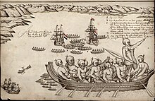
1642: Meeting with Abel Tasman[]
The Ngāti Tūmatakōkiri people were the first known iwi to interact with Europeans, when Dutch explorer Abel Tasman on 13 December 1642, the ship Heemskerck sailed into the Wainui Inlet of the Nelson Region by the 18 December 1642.[4] The Ngāti Tūmatakōkiri sent two waka, and blasted pūkāea or pūtātara (trumpets) at the ship, which returned a trumpet sound and fired a cannon at the waka. The next morning, many waka came to attack the Dutch ships, and four Dutch sailors were killed after one smaller boat was rammed by a waka,[4] while one member of the Ngāti Tūmatakōkiri war party was shot by the Dutch sailors.[5] Tasman's crew raised their anchor and left the area, without ever landing ashore.[1]
Decline[]

By the late 1700s, the Ngāti Tūmatakōkiri faced a new threat from the Ngāti Apa tribe, whom launched frequent waka canoe attacks on the Nelson region from their home base in the Kapiti coast of the lower North Island. The Ngāti Tūmatakōkiri were simultaneously harassed by the Ngāti Kuia tribe that resided in the Marlborough region to the east.[6] The reasons for these intrusions was for the securing of greenstone trail of which the various tribes needed to cross Ngāti Tūmatakōkiri-controlled land in order to reach the greenstone deposits of the West Coast of the South Island. The Ngāti Tūmatakōkiri planned a massive wave of canoe attacks on the Ngāti Apa home base at Kapiti coast with the intention to occupy Kapiti Island. However, unfavourable winds resulted in several canoes capsizing and the survivors were finished off by their enemies by the time they reached the shores of Kapiti Island. This left Ngāti Tūmatakōkiri vulnerable to reprisal attacks from all three neighbouring tribes and their controlled land was gradually wrested from them.
In the late 18th century, Ngāti Tūmatakōkiri conflict with Ngāi Tahu on the West Coast and Canterbury lasted for a period of 10-15 years, sparked by a series of events where Wereta Tainui, son of Tuhuru of Poutini Ngāi Tahu, abducted Kokore Ngati Tumatakokiri and took her as a wife, and in retaliation Ngāi Tahu chief Pakeke was killed at Maruia.[7] Ngāti Apa took advantage of this, and attacked Ngāti Tūmatakōkiri from the east of their rohe at Te Taitapu in Golden Bay / Mohua.[8] Ngāi Tahu and Ngāti Apa were joined by Ngāti Kuia and Rangitāne, culminating in a battle in the Paparoa Ranges circa 1810 where Ngāti Tūmatakōkiri were defeated,[2][9] and Tuhuru a chief of Poutini Ngāi Tahu, killed Te Pau and Te Kokihi, the paramount chiefs of Ngāti Tūmatakōkiri, and their followers.[3] The remaining people were enslaved, and their rohe was split between the tribes: Ngāi Tahu taking the lands on the West Coast, Ngāti Apa settling in the Nelson region, and Ngāti Kuia controlling the eastern Tasman Bay.[1] When Te Rauparaha invaded the region in the 1820s and 1830s, people who had been taken by Ngāti Apa were made to live as slaves within different iwi, Ngāti Toa, Ngāti Koata, Ngāti Rārua, Te Āti Awa and Ngāti Tama.[1]
In 1846, a Ngāti Tūmatakōkiri tohunga named Kehu (Hone Mokehakeha) assisted European explorers Charles Heaphy and Thomas Brunner in exploring the upper South Island.[1][10] Kahu Peak in the Saint Arnaud Range is named after this tohunga.[11]
While Ngāti Tūmatakōkiri is not currently an autonomous iwi, some members of Ngāti Kuia and Ngāi Tahu descend from Ngāti Tūmatakōkiri.[2] In 2017, people who had Ngāti Tūmatakōkiri ancestry took place in the ceremonies celebrating 375 years since the contact between Tasman's crew and Ngāti Tūmatakōkiri.[12][13]
References[]
- ^ a b c d e f Mitchell, John; Mitchell, Hilary (April 2020). "Ngāti Tūmatakōkiri". The Prow: Ngā Kōrero o te Tau Ihu. Retrieved 18 September 2021.
- ^ a b c d Mitchell, Hillary (10 February 2015). "Te Tau Ihu". Te Ara: The Encyclopedia of New Zealand. Ministry for Culture and Heritage. Retrieved 15 September 2016.
- ^ a b Smith, S. Percy (10 February 2015). "HISTORY AND TRADITIONS OF THE MAORIS OF THE WEST COAST, NORTH ISLAND OF NEW ZEALAND, PRIOR TO 1840". New Zealand Electronic Text Collection. Retrieved 15 September 2016.
- ^ a b "First known encounter between Māori and Europeans". Te Ara: The Encyclopedia of New Zealand. Ministry for Culture and Heritage. 23 September 2020. Retrieved 18 September 2021.
- ^ Wilson, John (1 May 2016). "Conflict at Murderers Bay". Te Ara: The Encyclopedia of New Zealand. Ministry for Culture and Heritage. Retrieved 18 September 2021.
- ^ History of Māori of Nelson and Marlborough
- ^ Mitchell, Hillary; Mitchell, John (1996). "Kehu (Hone Mokehakeha): Biographical Notes". Nelson Historical Society Journal. 6 (1). Retrieved 18 September 2021 – via New Zealand Electronic Text Collection.
- ^ Mitchell, Hillary; Mitchell, John (22 March 2017). "Ngāti Apa ki te Rā Tō". Te Ara: The Encyclopedia of New Zealand. Ministry for Culture and Heritage. Retrieved 18 September 2021.
- ^ Dawber, Carol; Win, Cheryl (March 2008). Between the ports : Collingwood to Waitapu. Dunedin: River Press. p. 33. ISBN 978-0-9582779-1-4.
- ^ Brunner, Thomas (1952) [First published in 1848]. The Great Journey: an expedition to explore the interior of the Middle Island, New Zealand, 1846–8. Christchurch, New Zealand: Pegasus Press. p. 102.
- ^ "Kehu Peak". New Zealand Gazetteer. Land Information New Zealand. Retrieved 18 September 2021.
- ^ Sivignon, Cherie (1 October 2017). "Commemoration plans of first encounter between Abel Tasman, Māori 375 years ago". Stuff. Retrieved 18 September 2021.
- ^ Angeloni, Alice (14 November 2018). "Iwi descendant celebrates Abel Tasman in Netherlands". Stuff. Retrieved 18 September 2021.
External links[]
- Iwi and hapū
- Te Tau Ihu Māori