Greymouth
Greymouth
Māwhera (Māori) | |
|---|---|
 Greymouth Clock Tower | |
 | |
| Coordinates: 42°28′S 171°12′E / 42.467°S 171.200°ECoordinates: 42°28′S 171°12′E / 42.467°S 171.200°E | |
| Country | New Zealand |
| Region | West Coast |
| District | Grey District |
| Ward | Central |
| Government | |
| • MP | Damien O'Connor (Labour) |
| • Mayor | Tania Gibson |
| Population (June 2020)[1] | |
| • Total | 8,170 |
| Postcode(s) | 7805 |
| Local iwi | Ngāi Tahu |

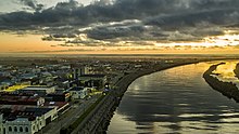
Greymouth (/ˈɡreɪmaʊθ/) (Māori: Māwhera) is the largest town in the West Coast region in the South Island of New Zealand, and the seat of the Grey District Council. The population of the whole Grey District is 13,800, which accounts for 43% of the West Coast's inhabitants. The Greymouth urban area had an estimated population of 8,170 (June 2020).[1]
Location[]

The town is located at the mouth of the Grey River, on a narrow coastal plain close to the foot of the Southern Alps. In clear weather, Aoraki / Mount Cook can be clearly seen to the south from near the town. The mouth of the river divides the town into three areas: Blaketown, close to the river's mouth on the south bank; Karoro, to the southeast, separated from Blaketown by a series of small estuarine lagoons; and Cobden, formerly a separate town, on the river's north bank.
Greymouth is on State Highway 6, which connects it with Hokitika in the south and Westport in the north. It also stands at the terminus of State Highway 7, which runs through Dobson and Reefton, eventually reaching North Canterbury and its junction with State Highway 1 at Waipara, 55 kilometres (34 mi) north of Christchurch, via Lewis Pass. Highway 73 is accessed 20 kilometres (12 mi) south of Greymouth, which is the most direct route to or from Christchurch. The town is also the western terminus of the Midland line from Christchurch. Large coal trains often operate from Greymouth on this line to Christchurch. The famous TranzAlpine train also terminates at Greymouth. The Greymouth Airport is only 1.9 kilometres (1.2 mi) south of the centre of the town.
Climate[]
Köppen-Geiger climate classification system classifies its climate as oceanic (Cfb).[2] Greymouth receives mean annual rainfall high by New Zealand standards and this rainfall is distributed relatively evenly throughout the year.[3] This is due to its position receiving marine westerlies throughout the year that often do not rise above the Southern Alps. As a result of this, it creates a rain shadow effect that sees east coast locations having far sunnier and warmer summers. This extreme marine influence also shelters the Greymouth area from hot summer days and cold winter nights. Snow is rare, the last reported event occurring on 4 August 2019.[4]
| hideClimate data for Greymouth Airport (1947–2015, Humidity 1972–2015) | |||||||||||||
|---|---|---|---|---|---|---|---|---|---|---|---|---|---|
| Month | Jan | Feb | Mar | Apr | May | Jun | Jul | Aug | Sep | Oct | Nov | Dec | Year |
| Record high °C (°F) | 28.8 (83.8) |
29.7 (85.5) |
27.7 (81.9) |
25.0 (77.0) |
23.8 (74.8) |
18.0 (64.4) |
18.1 (64.6) |
19.3 (66.7) |
22.3 (72.1) |
23.2 (73.8) |
26.5 (79.7) |
28.8 (83.8) |
29.7 (85.5) |
| Average high °C (°F) | 19.7 (67.5) |
19.9 (67.8) |
18.9 (66.0) |
16.8 (62.2) |
14.5 (58.1) |
12.4 (54.3) |
11.9 (53.4) |
12.8 (55.0) |
14.1 (57.4) |
15.1 (59.2) |
16.5 (61.7) |
18.4 (65.1) |
15.9 (60.6) |
| Daily mean °C (°F) | 16.1 (61.0) |
16.3 (61.3) |
15.2 (59.4) |
13.1 (55.6) |
10.9 (51.6) |
8.8 (47.8) |
8.1 (46.6) |
9.0 (48.2) |
10.4 (50.7) |
11.7 (53.1) |
13.1 (55.6) |
14.9 (58.8) |
12.3 (54.1) |
| Average low °C (°F) | 12.5 (54.5) |
12.7 (54.9) |
11.5 (52.7) |
9.5 (49.1) |
7.3 (45.1) |
5.2 (41.4) |
4.3 (39.7) |
5.2 (41.4) |
6.8 (44.2) |
8.3 (46.9) |
9.7 (49.5) |
11.5 (52.7) |
8.7 (47.7) |
| Record low °C (°F) | 3.8 (38.8) |
1.5 (34.7) |
0.1 (32.2) |
−0.1 (31.8) |
−2.2 (28.0) |
−2.5 (27.5) |
−2.4 (27.7) |
−2.4 (27.7) |
−2.4 (27.7) |
−0.7 (30.7) |
1.0 (33.8) |
2.9 (37.2) |
−2.5 (27.5) |
| Average rainfall mm (inches) | 202.3 (7.96) |
161.5 (6.36) |
188.6 (7.43) |
209.5 (8.25) |
220.7 (8.69) |
218.0 (8.58) |
193.6 (7.62) |
191.6 (7.54) |
197.3 (7.77) |
225.1 (8.86) |
210.1 (8.27) |
225.6 (8.88) |
2,442.5 (96.16) |
| Average rainy days (≥ 1.0 mm) | 12.5 | 10.8 | 12.6 | 13.7 | 15.4 | 14.6 | 13.9 | 15.0 | 15.9 | 17.4 | 15.5 | 15.0 | 171.4 |
| Average relative humidity (%) (at 9am) | 82.5 | 84.4 | 84.4 | 84.8 | 85.5 | 84.3 | 83.5 | 82.0 | 82.1 | 82.1 | 81.2 | 82.1 | 83.1 |
| Mean monthly sunshine hours | 196.7 | 173.2 | 157.6 | 131.4 | 104.5 | 89.6 | 107.9 | 130.3 | 135.8 | 147.7 | 164.1 | 173.8 | 1,719.1 |
| Source: CliFlo[5] | |||||||||||||
History[]
Māori had lived in Greymouth for a considerable time before European settlement, and called the area Māwhera (for 'wide spread river mouth',[6] still an alternative name for the Grey River). The first Europeans to visit the site of what is now Greymouth were Thomas Brunner and Charles Heaphy in 1846.
Brunner discovered coal in the , and several places in the region (notably the town of Brunner and Lake Brunner) bear his name. Brunner himself named the Grey River after Sir George Grey, Governor of New Zealand.[7]
As numbers of colonists continued to increase in Nelson and Canterbury, interest grew in settling the West Coast, but the land was still owned by Māori – Poutini Ngāi Tahu. In 1857 Poutini Ngāi Tahu chiefs wrote to Donald McLean, the New Zealand government land purchase officer, offering to sell the land for £2500, as long as some land was reserved for their use, and they kept their rights to the pounamu (greenstone) of the Arahura River.[8] In 1859, James Mackay was sent to broker a purchase deal, the Arahura Deed. This was signed in Māwhera by leading chiefs on 21 May 1860, and sold the entire West Coast to the Crown for just £300 ($36,000 in 2019 dollars), apart from a scattering of reserves totalling 4,000 hectares (40 km2).[9] (Just after the signing, Mackay capsized his canoe in the Grey River, and some of the writing in the document is smudged to this day.)[9] The reserves included Māwhera, now the centre of Greymouth.
On 22 July 1864 the 'Nelson' became the first steamer to cross the Grey bar and steam up the Grey River.[10] Aboard the 'Nelson' were Matthew Batty and Reuben Waite plus approximately 70 prospectors.[10] Reuben Waite would open the first store in Greymouth on the banks of the Grey River at the corner of which is now Waite St and Mawhera Quay.[11] Matthew Batty would become the first European coal miner on the Grey River overseeing a group of Māori digging up the Brunner Seam on the Grey River bank.[11]
John Rochfort undertook the original survey of the site of the township in 1865.[12][13] Greymouth was proclaimed a Borough on 16 July 1868, and on 26 August 1868 an election was held. On 16 September 1868 the new borough council held its first meeting and unanimously elected Mr Edward Masters as the first Mayor of Greymouth.[14]

From 1853 until the abolition of provinces in 1876, Greymouth was first part of Canterbury Province (the West Coast part of the Province was known as West Canterbury) and then part of an independent Westland Province. However Cobden, on the north (or right) bank of the Grey River was a part of Nelson Province from 1853 to 1876. The boundary between the Canterbury and Nelson provinces had been set as a straight line from the head of the Hurunui River to Lake Brunner at a time when the area was virtually uninhabited, but the West Coast Gold Rush straddled that boundary, with a population boom also straddling the boundary.[15] In 1866, there had been a proposal for portions of Canterbury Province, including the urban area of Greymouth and the rural area south, to be annexed and solely administered by Nelson Province.[16] The situation for the citizens of the area was partially alleviated with the creation of the County of Westland – which had all the administrative powers of a provincial council, but saw the legislative powers remain with Parliament in Wellington. Members of Parliament were not happy with having to spend their time on local legislation, and in 1873 the government elevated the county to full provincial status as Westland Province.
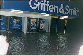
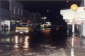
Flooding[]
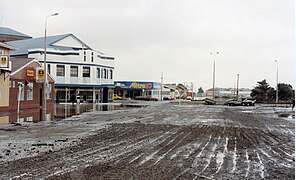
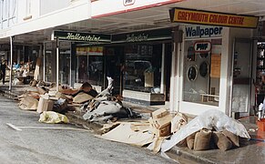
Greymouth was regularly flooded by the Grey River. Since the 1860s, the town had been under water almost two dozen times. When the town was flooded twice in 1988, the mayor of Greymouth, Barry Dallas, embarked on an ambitious project to build a flood protection wall. Since its completion, river flooding has not affected the town again.[17]
In 1988 flooding occurred in May and September. The May event brought flooding to the West Coast, particularly the Greymouth area. A Civil Defence Emergency was declared for the Greymouth Borough on 20 May, and roads and properties suffered damage. Four hundred people had to be evacuated with 102 houses affected and 2 being condemned.[18]
- Greymouth floods of May 1988


Greymouth also has an historic World War II gun emplacement at Cobden. The Grey District Council destroyed part of this site, without consultation, in 2007 to make way for a sewer line.[19]
On 10 March 2005, a major tornado, which started as a waterspout, made landfall in the suburb of Blaketown. It quickly moved through the town passing just south of the main town centre. The tornado was one of the largest reported in recent history in the West Coast region, caused millions of dollars in damage, and injured several people.[20] Previous tornadoes which had struck Greymouth on 16 June 2003 and 28 March 2001 had destroyed several buildings.[20]
Demographics[]
| Year | Pop. | ±% p.a. |
|---|---|---|
| 1991 | 10,059 | — |
| 1996 | 10,254 | +0.38% |
| 2001 | 9,528 | −1.46% |
| 2006 | 8,229 | −2.89% |
| 2013 | 8,118 | −0.19% |
| 2018 | 7,962 | −0.39% |
| Source: [21][22] | ||
Greymouth, comprising the statistical areas of Cobden, Blaketown, Greymouth Central, King Park, Marsden, Karoro and Rutherglen-Camerons, had a population of 7,962 at the 2018 New Zealand census, a decrease of 156 people (-1.9%) since the 2013 census, and a decrease of 267 people (-3.2%) since the 2006 census. There were 3,345 households. There were 3,933 males and 4,038 females, giving a sex ratio of 0.97 males per female, with 1,398 people (17.6%) aged under 15 years, 1,356 (17.0%) aged 15 to 29, 3,573 (44.9%) aged 30 to 64, and 1,641 (20.6%) aged 65 or older.
Ethnicities were 90.9% European/Pākehā, 10.6% Māori, 1.5% Pacific peoples, 3.8% Asian, and 2.1% other ethnicities (totals add to more than 100% since people could identify with multiple ethnicities).
The proportion of people born overseas was 11.5%, compared with 27.1% nationally.
Although some people objected to giving their religion, 51.3% had no religion, 37.5% were Christian, 0.7% were Hindu, 0.4% were Muslim, 0.2% were Buddhist and 2.0% had other religions.
Of those at least 15 years old, 765 (11.7%) people had a bachelor or higher degree, and 1,839 (28.0%) people had no formal qualifications. The employment status of those at least 15 was that 3,144 (47.9%) people were employed full-time, 1,023 (15.6%) were part-time, and 198 (3.0%) were unemployed.[22]
| Name | Population | Households | Median age | Median income |
|---|---|---|---|---|
| Cobden | 1,551 | 666 | 40.5 years | $21,900[23] |
| Blaketown | 810 | 375 | 42.2 years | $27,000[24] |
| Greymouth Central | 978 | 402 | 52.7 years | $23,900[25] |
| King Park | 1,053 | 486 | 45.1 years | $24,800[26] |
| Marsden | 1,221 | 495 | 38.6 years | $34,400[27] |
| Karoro | 1,017 | 408 | 47.1 years | $37,000[28] |
| Rutherglen-Camerons | 1,332 | 513 | 46.5 years | $37,500[29] |
| New Zealand | 37.4 years | $31,800 |
Rural area[]
| Year | Pop. | ±% p.a. |
|---|---|---|
| 2006 | 564 | — |
| 2013 | 663 | +2.34% |
| 2018 | 693 | +0.89% |
| Source: [30] | ||
The statistical area of Greymouth Rural, which covers 340 square kilometres between Greymouth and Lake Brunner, had a population of 693 at the 2018 New Zealand census, an increase of 30 people (4.5%) since the 2013 census, and an increase of 129 people (22.9%) since the 2006 census. There were 285 households. There were 363 males and 330 females, giving a sex ratio of 1.1 males per female. The median age was 47.1 years (compared with 37.4 years nationally), with 114 people (16.5%) aged under 15 years, 105 (15.2%) aged 15 to 29, 369 (53.2%) aged 30 to 64, and 108 (15.6%) aged 65 or older.
Ethnicities were 94.4% European/Pākehā, 10.4% Māori, 0.4% Pacific peoples, 0.9% Asian, and 2.2% other ethnicities (totals add to more than 100% since people could identify with multiple ethnicities).
The proportion of people born overseas was 9.5%, compared with 27.1% nationally.
Although some people objected to giving their religion, 59.3% had no religion, 30.7% were Christian, 0.4% were Hindu, 0.4% were Buddhist and 2.2% had other religions.
Of those at least 15 years old, 69 (11.9%) people had a bachelor or higher degree, and 144 (24.9%) people had no formal qualifications. The median income was $32,100, compared with $31,800 nationally. The employment status of those at least 15 was that 315 (54.4%) people were employed full-time, 90 (15.5%) were part-time, and 21 (3.6%) were unemployed.[30]
Economy[]
Greymouth was founded during the West Coast gold rush of the 1860s, but for 150 years after this its economy was based on coal mining and native timber forestry. These brought prosperity to the town which at one point had 47 hotels (today it has only six).[31] In 2020 most of the coal mines have now closed yet at there were once ten coal mines in the Brunner Field. Brunner (1861–1935), Tyneside (1876–1954), Wallsend (1894–1932), Coal Pit Heath (1877–1893), Coolgardie (1894–1932), Pig and Whistle (1900–1944), South Brunner (1906–1907), St Kilda (1907–1921), North Brunner (1908–1920), Dobson (1920–1968).[32] The 10 mines produced over 8 million tonnes of coal.[32] The coal reserves in the district including - measured, indicated, and inferred total 164 million tonnes.[14] Fishing has long been important to the town, despite the fact that the entrance to the Grey River has two notoriously dangerous sandbars; an inner and outer bar.[33]
Beginning in the 1960s, forestry and coal mining began to decline on the West Coast. The planned opening of the Pike River Mine in early 2008 spurred new investments in upgrading port facilities at the town.[34] The opening of the new mine, as well as the planned Spring Creek mine, was called the biggest investment happening in the area for a hundred years; coal barges travelling to and from reshipment facilities in Taranaki would have carried containerised cargo to the town and saved the port from closure.[35] On 19 November 2010, there was an explosion at the Pike River Mine, trapping 29 miners.[36] Attempts to rescue the trapped miners were repeatedly delayed due to high levels of methane gas, until a second explosion on 24 November dashed all hope of survival for the miners.[37] Pike River Coal went into receivership in the wake of the disaster and was purchased by Solid Energy, which closed the Spring Creek Mine in 2012 with the loss of 220 jobs and went into voluntary administration in August 2015.
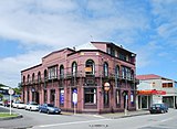
After the decline in coal mining and forestry, the West Coast economy has become increasingly dependent on ecotourism. Thousands of coal mining jobs had declined to just 60, and hundreds of tourism jobs had replaced them.[31] During Greymouth's boom years, much of the centre of town was built up in brick Art Deco building on leased land in the Mawhera Reserve. This land was administered for many years by the Department of Maori Affairs, but was returned to the control of the iwi in 1976. At that time Mawhera Inc's total assets were worth $2m, but had grown to $123m by 2018. Mawhera Inc is now the town's largest landlord, with 1600 shareholders.[31] After regulations were tightened following the 2010 Canterbury earthquake, many of Greymouth's heritage buildings were found to be unsafe, and the combination of earthquake-strengthening costs and being on lease land makes many of them uneconomic to restore and occupy.[31]
Greymouth is also known for its pounamu ("greenstone", a form of jade) carving industry which goes back to Māori origins. The town's local brewery, Monteith's, has produced beer since 1868 which is now sold nationwide.[7]
Education[]
Greymouth has several state primary schools offering education up to year 8, and Greymouth High School providing secondary education. There are also state-integrated Catholic primary and secondary schools.
Tai Poutini Polytechnic has its head office based in Greymouth. It also has campuses in Auckland, Christchurch, Hokitika, Reefton, Wanaka and Westport.
Suburbs[]
- Inner suburbs:
- Cobden – reflects the English origins and political awareness of its founders. Many of the streets are named for English political rebels and reformers of their times. Richard Cobden (1804–1865) was a radical politician involved in repealing the Corn Laws, emancipating the worker and encouraging free trade. Some of his contemporaries such as John Bright and Edward Cardwell also have streets named after them. Other more recent streets honour some of Cobden's significant citizens.[38]
 Southern Breakwater in Blaketown
 - Greymouth Central – Māwhera to Māori but renamed 'Grey' to honour the then Governor of New Zealand Sir George Grey. The earliest street names honour pioneer residents, explorers and prominent local Māori, while others pay tribute to English literary figures and politicians. Later developments recognise the achievements of local residents who contributed significantly to civic and local body affairs.[38]
- Blaketown – named for its founder, Isaac Blake who, according to his contemporaries, although unable to read was a wily and ambitious character. He came as a gold prospector but soon saw that there was more money to be made as a trader and storekeeper. In its early days, Blaketown was bigger than Greymouth. Blaketown shows the influence of early politicians in its street names.[38]
- Wharemoa
- Karoro - the meaning in Māori is 'blacked-backed gull' or 'seagull'. The streets of Karoro, which are mostly the result of more recent subdivision, reflect the names of developers or landowners in the area. Some are named for geographic features and native trees.[38]
- Outer suburbs:
- South Beach
- Paroa – the meaning in Māori is 'long fortified village'. The area around the Saltwater Creek was so named in 1866 when upwards of two thousand men were prospecting in the area. The streets of Paroa are mostly named for prominent citizens and landowners.[38]
- Rutherglen
- Gladstone
- Camerons

Notable people[]
- Mary Anderson (1887–1966), politician and founding member of the Greymouth branch of the New Zealand Labour Party
- Julie Christie (born 1962), television producer who grew up in Greymouth
- Paul Coll (born 1992), squash player born in Greymouth
- Arthur Guinness (1846–1913), lawyer and politician
- Kevin Hague (born 1960), politician and chief executive who lives in Greymouth
- Tony Kokshoorn (born 1955), politician, activist and publisher born and lives in Greymouth
- Janice M. Morse (born 1945), medical researcher who grew up in Greymouth
- Bill Pearson (1922–2002), writer born in Greymouth
- Mark Priest (born 1961), cricketer born in Greymouth
- Gaylene Preston (born 1947), filmmaker born in Greymouth
- Blair Tennent (1898–1976), politician who grew up in Greymouth
- Leigh Hart (born 1970), comedian and radio announcer born in Greymouth
- Jackie Thomas (born 1990) singer born in Greymouth
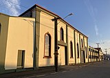
Notable buildings[]
- (1 Tainui Street), now home of the Leftbank Art Gallery
- (45–49 Tainui Street), now demolished

The former Greymouth Government buildings

Greymouth Courthouse building

Left Bank Art Gallery, in the old Bank of New Zealand building

History House museum, the former Grey County Chambers
Greymouth Royal Hotel
Dispatch & Garlick Foundry


See also[]
References[]
- ^ Jump up to: a b "Population estimate tables - NZ.Stat". Statistics New Zealand. Retrieved 22 October 2020.
- ^ "Climate: Greymouth – Climate graph, Temperature graph, Climate table". Climate-Data.org. Retrieved 30 January 2014.
- ^ "Western South Island". www.niwa.co.nz. 28 February 2007. Retrieved 13 December 2015.
- ^ Harris, Dominic. "Short-lived snow flurries will live long in the memory for Coasters". Stuff.co.nz. Retrieved 5 August 2019.
- ^ "CliFlo – National Climate Database". NIWA. Retrieved 14 December 2015.
- ^ Greymouth (from Tourism New Zealand, the official New Zealand tourism agency)
- ^ Jump up to: a b Greymouth / Blackball Archived 14 October 2008 at the Wayback Machine (from the Tourism West Coast website)
- ^ Nathan, Simon (1 September 2016). "Letter from Poutini Chiefs". Te Ara – the Encyclopedia of New Zealand. Retrieved 9 September 2020.
- ^ Jump up to: a b Nathan, Simon (2016). "West Coast region – European arrival and settlement". Te Ara – the Encyclopedia of New Zealand. Retrieved 9 September 2020.
- ^ Jump up to: a b Bradshaw, Julia, ed. (2014). The Diggers' Story: Accounts of the West Coast gold rushes. Christchurch: Canterbury University Press. p. 22. ISBN 978-1-927145-60-9.
- ^ Jump up to: a b "West Coast History – Grey District Council". www.greydc.govt.nz. Retrieved 12 September 2020.
- ^ McLintock, A. H., ed. (22 April 2009) [First published in 1966]. "Greymouth". An Encyclopaedia of New Zealand. Ministry for Culture and Heritage / Te Manatū Taonga. Retrieved 14 September 2015.
- ^ Pollard, John. "Rochfort, John". Dictionary of New Zealand Biography. Ministry for Culture and Heritage. Retrieved 27 March 2014.
- ^ Jump up to: a b Kerridge, Peter, 1942– (1993). Glimpses of Greymouth and district : a 1993 record of the development of Greymouth and district over the past one hundred and twenty-five years and some of the activities and achievements of its citizens, councils and community organisations, 1868–1993. Grey District (N.Z.). District Council. Greymouth, N.Z.: 125th Jubilee Committee of the Grey District Council. p. 65. ISBN 0-473-02367-9. OCLC 154645099.CS1 maint: multiple names: authors list (link)
- ^ McLintock, A. H., ed. (22 April 2009) [First published in 1966]. "Westland Province and Provincial District". An Encyclopaedia of New Zealand. Ministry for Culture and Heritage / Te Manatū Taonga. Retrieved 5 December 2013.
- ^ "Proposal to Join the Grey District to Nelson Province". Grey River Argus. 21 March 1866. Retrieved 5 November 2018.
- ^ Crean, Mike (30 May 2008). "A mayor with a big flood idea". The Press. Retrieved 18 September 2015.
- ^ "May 1988 West Coast Flooding (1988-05-19)". hwe.niwa.co.nz. Retrieved 7 July 2019.
- ^ Cobden Coastal Defence Gun Emplacement (from the 'nzrifle.com' website. Accessed 16 January 2008.)
- ^ Jump up to: a b "Widespread damage after Greymouth tornado". The New Zealand Herald. 10 March 2005. Retrieved 9 September 2020.
- ^ Statistics New Zealand (2002). 2001 Census Regional Summary - Volume 1. Wellington: Information and Publishing Services Division of Statistics New Zealand. p. 25. ISBN 0-478-26906-4.
- ^ Jump up to: a b "Statistical area 1 dataset for 2018 Census". Statistics New Zealand. March 2020. Cobden (310100), Blaketown (310200), Greymouth Central (310300), King Park (310400), Marsden (310500), Karoro (310600) and Rutherglen-Camerons (310700).
- ^ 2018 Census place summary: Cobden
- ^ 2018 Census place summary: Blaketown
- ^ 2018 Census place summary: Greymouth Central
- ^ 2018 Census place summary: King Park
- ^ 2018 Census place summary: Marsden
- ^ 2018 Census place summary: Karoro
- ^ 2018 Census place summary: Rutherglen-Camerons
- ^ Jump up to: a b "Statistical area 1 dataset for 2018 Census". Statistics New Zealand. March 2020. Greymouth Rural (310800). 2018 Census place summary: Greymouth Rural
- ^ Jump up to: a b c d Carroll, Joanne (9 March 2018). "Greymouth is decaying – can it be saved?". Stuff. Retrieved 8 September 2020.
- ^ Jump up to: a b Kerridge, Peter (1993). Glimpses of Greymouth and District. Greymouth: 125th Jubilee Committee of the Grey District Council. p. 65. ISBN 0473023679.
- ^ "Greymouth bar braved by experienced fisherman – NZ News – Video". 3 News. Archived from the original on 20 April 2012. Retrieved 16 October 2012.
- ^ How the West was won:Pike River on track – New Zealand Construction News, Volume 2, Issues 3, July 2007
- ^ Graham, Pam (14 January 2007). "Pike River coal mine goes ahead on DOC land". The New Zealand Herald.
- ^ "Timeline – Pike River mine explosion". The Press. 21 November 2010. Retrieved 2 October 2011.
- ^ Beswick, Angela (24 November 2010). "Second explosion, no survivors". TV3 News. Archived from the original on 11 February 2012. Retrieved 30 November 2010.
- ^ Jump up to: a b c d e Buckley, Frances (2004). Greymouth street names: a short history (2 ed.). Greymouth: Grey District Library. ISBN 0-476-00294-X.
External links[]
| Wikivoyage has a travel guide for Greymouth. |
| Wikimedia Commons has media related to Greymouth. |
- The district council's website
- Greymouth Street Map
- Photo of the road and rail bridges c1930
- Photo of SS Opouri off Greymouth bar c1948
| Authority control |
|---|
- Greymouth
- Grey District
- Populated places in the West Coast, New Zealand