Westport, New Zealand
Westport
Kawatiri (Māori) | |
|---|---|
 | |
 | |
| Coordinates: 41°45′29″S 171°36′8″E / 41.75806°S 171.60222°ECoordinates: 41°45′29″S 171°36′8″E / 41.75806°S 171.60222°E | |
| Country | New Zealand |
| Region | West Coast |
| District | Buller District |
| Ward | Westport |
| Electorates | West Coast-Tasman Te Tai Tonga |
| Population (June 2020)[1] | |
| • Total | 4,380 |

Westport (Māori: Kawatiri) is a town in the West Coast region of the South Island of New Zealand. Established in 1861, it is the oldest European settlement on the West Coast.[2] Originally named Buller,[3] it is on the right bank and at the mouth of the Buller River, close by the prominent headland of Cape Foulwind. It is connected via State Highway 6 with Greymouth, 100 kilometres (62 mi) to the south, and with Nelson 222 kilometres (138 mi) in the northeast, via the Buller Gorge. The population of the Westport urban area was 4,380 as of June 2020. The Buller District had a population of 9,610.
Name[]
The Māori language name for the river and the region is Kawatiri, meaning deep and swift.[4] The town is thought to have been named after Westport, County Mayo in Ireland, although the choice of name was no doubt also guided by its location.[3]
History[]
From an archaeological excavation site, near the mouth of the Buller River (Kawatiri), it is clear that Māori were living close to Westport by the early 14th century.[5] Māori mostly lived in coastal areas, though they explored the mountains for pounamu (jade or greenstone), which they then traded with other iwi.[6]
The first wave of European settlers came to Westport in 1861 as gold miners,[7] and the first European vessel said to have entered the river was the sealing schooner Three Brothers in 1834.[citation needed] The 1880s saw many exploratory parties of geologists and surveyors combing the area for the presence of valuable resources and taking the measure of the land. Amongst them were Charles Heaphy, William Fox and Thomas Brunner. While gold brought initial interest to the area, and for example, led to large areas of the coastal areas (covered by sediment from the river) being dredged for the valuable mineral,[citation needed] the area soon became much more famous for coal mining, still a dominant concern in the region today.[6]

A coal mining company was formed in 1878 called the Westport Colliery Company Ltd, and then became The Westport Coal Company in 1881 when a group of Dunedin businessmen purchased the mines.[8] The coal fields were at Coalbrookdale (Denniston) and Granity Creek (Millerton) and coal was transported to the Westport harbour to be shipped out. By 1905 The Westport Coal Company was New Zealand’s largest coal producer.[9] The Coaltown Museum in Westport illustrates the history of the Buller District.[10]
Westport was administrated as part of the Nelson Province from 1853 to 1876.
Westport has been damaged by several earthquakes, the worst the 1929 Murchison earthquake, in which several buildings collapsed, including the post office tower. The town now has a number of Art Deco buildings that were constructed after the earthquake,[3] for example the Clock Tower Chambers.[11]
Geography[]
Climate[]
The Westport climate is strongly influenced by the high amount of precipitation from the Tasman Sea, with all months except February being rather wet on average. Despite very high annual rainfall, Westport is often prone to drought and conservation measures are sometimes triggered. While colder than the more northern parts of New Zealand, average temperature changes over the year are not extreme.
| hideClimate data for Westport | |||||||||||||
|---|---|---|---|---|---|---|---|---|---|---|---|---|---|
| Month | Jan | Feb | Mar | Apr | May | Jun | Jul | Aug | Sep | Oct | Nov | Dec | Year |
| Average high °C (°F) | 20 (68) |
20.4 (68.7) |
19.5 (67.1) |
17.2 (63.0) |
14.7 (58.5) |
13 (55) |
12.6 (54.7) |
13.2 (55.8) |
14.3 (57.7) |
15.3 (59.5) |
16.9 (62.4) |
18.6 (65.5) |
16.3 (61.3) |
| Average low °C (°F) | 12.4 (54.3) |
12.7 (54.9) |
12 (54) |
9.8 (49.6) |
7.3 (45.1) |
5.3 (41.5) |
4.6 (40.3) |
5.5 (41.9) |
7 (45) |
8.3 (46.9) |
10 (50) |
11.5 (52.7) |
8.8 (47.8) |
| Average precipitation mm (inches) | 189 (7.4) |
133 (5.2) |
171 (6.7) |
192 (7.6) |
209 (8.2) |
199 (7.8) |
187 (7.4) |
187 (7.4) |
201 (7.9) |
198 (7.8) |
183 (7.2) |
215 (8.5) |
2,274 (89.5) |
| Source: NIWA Climate Data[12] | |||||||||||||
Demographics[]
| Year | Pop. | ±% p.a. |
|---|---|---|
| 2006 | 4,509 | — |
| 2013 | 4,755 | +0.76% |
| 2018 | 4,389 | −1.59% |
| Source: [13] | ||
Westport, comprising the statistical areas of Westport North and Westport South, had a population of 4,389 at the 2018 New Zealand census, a decrease of 366 people (-7.7%) since the 2013 census, and a decrease of 120 people (-2.7%) since the 2006 census. There were 1,998 households. There were 2,214 males and 2,172 females, giving a sex ratio of 1.02 males per female, with 729 people (16.6%) aged under 15 years, 651 (14.8%) aged 15 to 29, 1,911 (43.5%) aged 30 to 64, and 1,092 (24.9%) aged 65 or older.
Ethnicities were 91.9% European/Pākehā, 12.1% Māori, 1.8% Pacific peoples, 2.7% Asian, and 1.6% other ethnicities (totals add to more than 100% since people could identify with multiple ethnicities).
The proportion of people born overseas was 9.2%, compared with 27.1% nationally.
Although some people objected to giving their religion, 56.3% had no religion, 33.6% were Christian, 0.5% were Hindu, 0.1% were Muslim, 0.3% were Buddhist and 1.8% had other religions.
Of those at least 15 years old, 303 (8.3%) people had a bachelor or higher degree, and 1,179 (32.2%) people had no formal qualifications. The employment status of those at least 15 was that 1,398 (38.2%) people were employed full-time, 561 (15.3%) were part-time, and 159 (4.3%) were unemployed.[13]
| Name | Population | Households | Median age | Median income |
|---|---|---|---|---|
| Westport North | 1,893 | 858 | 48.1 years | $21,500[14] |
| Westport South | 2,496 | 1,140 | 47.5 years | $23,100[15] |
| New Zealand | 37.4 years | $31,800 |
Rural surrounds[]
| Year | Pop. | ±% p.a. |
|---|---|---|
| 2006 | 975 | — |
| 2013 | 1,230 | +3.37% |
| 2018 | 1,260 | +0.48% |
| Source: [16] | ||
Westport Rural had a population of 1,260 at the 2018 New Zealand census, an increase of 30 people (2.4%) since the 2013 census, and an increase of 285 people (29.2%) since the 2006 census. There were 498 households. There were 624 males and 639 females, giving a sex ratio of 0.98 males per female. The median age was 50.1 years (compared with 37.4 years nationally), with 249 people (19.8%) aged under 15 years, 96 (7.6%) aged 15 to 29, 606 (48.1%) aged 30 to 64, and 306 (24.3%) aged 65 or older.
Ethnicities were 94.0% European/Pākehā, 8.8% Māori, 0.7% Pacific peoples, 1.7% Asian, and 2.1% other ethnicities (totals add to more than 100% since people could identify with multiple ethnicities).
The proportion of people born overseas was 9.0%, compared with 27.1% nationally.
Although some people objected to giving their religion, 55.7% had no religion, 32.9% were Christian, 0.5% were Hindu, 0.5% were Buddhist and 1.9% had other religions.
Of those at least 15 years old, 129 (12.8%) people had a bachelor or higher degree, and 285 (28.2%) people had no formal qualifications. The median income was $24,900, compared with $31,800 nationally. The employment status of those at least 15 was that 441 (43.6%) people were employed full-time, 192 (19.0%) were part-time, and 21 (2.1%) were unemployed.[16]
Economy[]
Economic activity is based around fishing, coal mining and dairy farming. Historically, gold mining was a major industry, and coal mining was much more extensive than today (especially in terms of employment numbers). However, the region still is home to New Zealand's largest opencast mining operation in Stockton.[17] Some native forest logging occurred in the area until cessation around 1999. The Holcim company had a large cement plant in the southwest side of town until its closure on 30 June 2016.[18]
Tourism has some famous destinations in this area, such as Cape Foulwind, Tauranga Bay with its large fur seal colony, and fine surfing beaches. The opening of the Old Ghost Road which runs between Lyell and Seddonville to the north of Westport has seen an explosion in the number of mountain bikers visiting the area. The Kawatiri Coastal Trail is under development between Westport, Carters Beach, Cape Foulwind, and Charleston.The Pūwaha Section of the trail from Westport to Carters Beach was the first of nine sections to be built. It was officially opened on 6 December 2020. The remaining sections are expected to be completed by June 2022.[19][20]
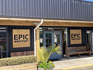
Westport is also home to EPIC Westport an innovation hub, which houses software developers and business startups.[21]
Rafting and jetboating in the Buller Gorge are also popular.[22] Many South Island visitors tend to overlook this quieter area, opting instead to go to Abel Tasman National Park, to Hanmer Springs or, if they do visit the West Coast, to Greymouth and the Fox- and Franz Josef glaciers further south, but for its history and numerous attractions Westport is itself a worthy destination. Westport is also a base for trips to Karamea and the Oparara Basin Arches with the only road access to the area running north from Westport.
A daily local newspaper is published in Westport, the Westport News. The Westport News building also houses coast-wide local radio station Coast FM.
Transport[]

Westport is served by State Highway 67, and the 8.9 km spur State Highway 67A to Carters Beach and Cape Foulwind which terminates at the former Holcim cement plant location.
The Holcim company managed the day-to-day operations of Westport's port until ceasing operations in the district, using it to ship their cement product to market,[23][24] for example to the Port of Onehunga in Auckland.
The first railway of the area in 1864[failed verification] ran from Westport 18 kilometres (11 mi) to the coal fields, most of them north of town.[25] The first section of railway from Westport to via Sergeants Hill opened on 31 December 1875; this line ultimately reached Seddonville in 1895 and was known as the Seddonville Branch. From this beginning, an isolated network of branch lines was developed: a Westport-Inangahua branch line of about 12 miles (19 km) was authorised by the Railways Authorisation Act, 1904.[26] But the lines were not linked to the national network until the completion of the Stillwater–Westport Line through the Buller Gorge in 1942.
Westport Airport is a small airport. It was formerly served twice daily on weekdays and daily in the weekend by Air New Zealand from Wellington, and prior to that, flights to Christchurch and Hokitika were also operated. The Air New Zealand service from Wellington service ceased in April 2015 and its place was taken by Sounds Air.
Facilities[]

The town used to have one cinema/theatre, the St James Theatre, able to seat 424 patrons for film screenings, theatre productions or other activities. After being found structurally unsound, the theatre had to be demolished. A new theatre has since opened. The NBS theatre has two movie theatres, one which seats 55 people and a boutique theatre that seats approximately 20 people. This theatre also has a large facility with seating for approximately 370 people and a stage for performing.[27]
The township also has a links-style, 18-hole, par-72 golf course. The course measures around 5,600 metres (18,400 ft) with medium to narrow fairways and small "target" greens.[28]
The Pulse Energy Recreation Centre (originally named the Solid Energy Centre), a sports complex, was opened on 18 April 2009.
Te Taha o Te Awa Marae is based at Westport. It is a marae (tribal meeting ground) of Ngāti Apa ki te Rā Tō and its Pūaha Te Rangi hapū, and includes a wharenui (meeting house), also called Te Taha o te Awa.[29][30]
Westport is home to the Sue Thomson Casey Memorial Library, located at 87–89 Palmerston Street. It is the Buller district library.[31]
Education[]

Buller High School is a secondary (years 9–13) school with a roll of 333.[32] The school celebrated its 75th anniversary in 1997[33] but also claims to have been operating for over 100 years, due to its connection to earlier secondary schooling in the district.[34]
Westport North School and Westport South School are full primary (years 1–8) schools with rolls of 222[35] and 241,[36] respectively. The schools were founded in 1942[37] and 1941[38]
St Canice's School is a full primary (years 1–8) school with a roll of 132.[39] It is a state integrated Catholic school[40] and has operated since at least 1882.[41]
All these schools are coeducational. The town's primary schools all have a decile rating of 4, and Buller High School has a decile rating of 3. School rolls are as of March 2021.[42]
Notable people[]

- Ben Blair – rugby union player
- James Colvin – politician
- G. F. J. Dart – educationalist, playwright
- Alan Deere – World War II fighter ace
- Anna Harrison – netball player
- Peter Hawes – playwright, author, actor
- Laura Suisted – journalist
Notable buildings[]
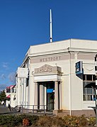
Westport Post Office

Former Bank of New Zealand building which now houses the Westport News
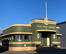
Buller County Chambers


References[]
- ^ "Population estimate tables - NZ.Stat". Statistics New Zealand. Retrieved 22 October 2020.
- ^ "Municipal Chambers (Former)". Heritage New Zealand.
- ^ Jump up to: a b c Nathan, Simon. "West Coast places – Westport". Te Ara: The Encyclopedia of New Zealand. Retrieved 29 August 2020.
- ^ Grzelewski, Derek (October–December 1997). "Buller—the mighty river". New Zealand Geographic. Retrieved 21 September 2020.
- ^ Nathan, Simon (1 September 2016). "West Coast region – Māori exploration and settlement".
- ^ Jump up to: a b History (from the Buller District Council website)
- ^ Welcome to the Buller District (from the 'Buller Community Development Company Ltd' website)
- ^ "Circa Theatre – Wellington Heritage". Wellington City Council Me Heke Ki Poneke. Retrieved 21 September 2020.
- ^ "Our History". Westport Harbour. Retrieved 21 September 2020.
- ^ Coaltown Museum (official museum website)
- ^ "Municipal Chambers (Former)". Register of Historic Places. Heritage New Zealand. Retrieved 29 August 2020.
- ^ "Climate Data". NIWA. Retrieved 2 November 2007.
- ^ Jump up to: a b "Statistical area 1 dataset for 2018 Census". Statistics New Zealand. March 2020. Westport North (309200) and Westport South (309400).
- ^ 2018 Census place summary: Westport North
- ^ 2018 Census place summary: Westport South
- ^ Jump up to: a b "Statistical area 1 dataset for 2018 Census". Statistics New Zealand. March 2020. Westport Rural (309300). 2018 Census place summary: Westport Rural
- ^ Stockton (Opencast) (from the Solid Energy website)
- ^ Carroll, Joanne (26 May 2016). "Job losses for Westport Harbour when Holcim closes". Stuff.
- ^ "About the Kawatiri Coastal Trail". Kawatiri Trail. Retrieved 22 March 2021.
- ^ "New West Coast Trail provides tourism boost thanks to PDU funding". Growregions.govt.nz. 7 December 2020. Retrieved 22 March 2021.
- ^ Baker, Glenn (27 February 2019). "Coastal confidence". NZBusiness. Retrieved 26 September 2020.
- ^ West Coast – History (from the Tourism New Zealand website)
- ^ Westport (from the Buller District Council website)
- ^ Harbour (from the Buller District Council website)
- ^ Westport Harbour (from the Transactions and Proceedings of the Royal Society of New Zealand, 1868–1961)
- ^ "Railways Authorisation Act, 1904". NZ Law online. 1904.
- ^ Theatres (from the Buller District Council website)
- ^ New Zealand, NZ, Golf Course Regions
- ^ "Te Kāhui Māngai directory". tkm.govt.nz. Te Puni Kōkiri.
- ^ "Māori Maps". maorimaps.com. Te Potiki National Trust.
- ^ "Buller District Council, New Zealand » Library locations & opening hours". Retrieved 23 September 2020.
- ^ Education Counts: Buller High School
- ^ Centennial Committee (1997). 75 years of memories 1922–1997 Westport Technical High School, Westport Technical College, Buller High School.
- ^ "Welcome to Buller High School". Buller High School. Retrieved 19 July 2008.
- ^ Education Counts: Westport North School
- ^ Education Counts: Westport South School
- ^ Illsley, Amber Jo (1992). Westport North Primary School Jubilee and reunion 1942–1992.
- ^ Jubilee Committee (1991). Westport South School 50th Jubilee 1941–1991.
- ^ Education Counts: St Canice's School
- ^ "Education Review Report: Saint Canice's School". Education Review Office. December 2007.
- ^ "St Canice's School Westport". New Zealand Tablet. 12 January 1883.
- ^ "New Zealand Schools Directory". New Zealand Ministry of Education. Retrieved 27 April 2021.
External links[]
| Wikivoyage has a travel guide for Westport (New Zealand). |
| Wikimedia Commons has media related to Westport, New Zealand. |
- Westport Tourism Website (Official Westport tourism website, Tourism New Zealand)
- Buller High School
- Westport North School
| Authority control |
|
|---|
- Westport, New Zealand
- Populated places in the West Coast, New Zealand
- Buller District