Taylorville, New Zealand
Taylorville | |
|---|---|
 Taylorville Road | |
 Taylorville | |
| Coordinates: 42°26′25.28″S 171°18′51.01″E / 42.4403556°S 171.3141694°E | |
| Country | New Zealand |
| Region | West Coast |
| District | Grey District |

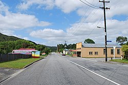
Taylorville is a small town on the banks of the Grey River, It is roughly 10 kilometers from the mouth of the river in Greymouth[1]
The local Taylorville swimming hole is popular for swimming and dog-walking, but West Coast Regional Council advises against swimming in it after heavy rain due to elevated levels of E. coli.[2]
Taylorville is also right next to the historic Brunner Mine site.[3]
Taylorville used to be connected to Wallsend, located on the opposite side of the Grey River, with a suspension bridge for pedestrians providing a connection. The bridge washed away in the 1960s.[4]
References[]
![]() Media related to Taylorville, New Zealand at Wikimedia Commons
Media related to Taylorville, New Zealand at Wikimedia Commons
- ^ Taylorville Map | New Zealand Google Satellite Maps
- ^ "Grey River Taylorville Swimming Hole". lawa.org.nz. Land, Air, Water Aotearoa.
- ^ "Brunner Mine Site Walk". www.mhftowns.com. Retrieved 5 September 2019.
- ^ Cyclopedia Company Limited (1906). "Brunnerton". The Cyclopedia of New Zealand : Nelson, Marlborough & Westland Provincial Districts. Christchurch: The Cyclopedia of New Zealand. Retrieved 1 September 2020.
Coordinates: 42°26′25.28″S 171°18′51.01″E / 42.4403556°S 171.3141694°E
This West Coast, New Zealand geography article is a stub. You can help Wikipedia by . |
- Grey District
- Populated places in the West Coast, New Zealand
- West Coast, New Zealand geography stubs