Paroa, West Coast
Paroa | |
|---|---|
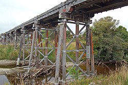 Paroa Trestle on the old Hokitika Branch line | |
 | |
| Coordinates: 42°30′39″S 171°10′9″E / 42.51083°S 171.16917°ECoordinates: 42°30′39″S 171°10′9″E / 42.51083°S 171.16917°E | |
| Country | New Zealand |
| Region | West Coast |
| District | Grey District |
| Ward | Southern |
| Local iwi | Ngāi Tahu |

Paroa is a settlement on the West Coast of the South Island of New Zealand, just south of Greymouth. State Highway 6 and the Hokitika Branch railway both run through Paroa.[1][2] This railway was originally a bush tramway that opened to Paroa from Greymouth in 1867 and was extended to Kumara in 1877.[3] It was converted into a railway in 1893, and this time, ran from Paroa to Hokitika rather than Kumara.[4]
The New Zealand Ministry for Culture and Heritage gives a translation of "broad fortified village" for Pāroa.[5]
Shantytown, to the south-east of Paroa, is a recreation of a typical 1880s West Coast gold mining town, built in 1971 and operating as a commercial tourist attraction.[6]
Demographics[]
| Year | Pop. | ±% p.a. |
|---|---|---|
| 2006 | 1,071 | — |
| 2013 | 1,197 | +1.60% |
| 2018 | 1,332 | +2.16% |
| Source: [7] | ||
The statistical area of Rutherglen-Camerons, which at 12 square kilometres is larger than this settlement, had a population of 1,332 at the 2018 New Zealand census, an increase of 135 people (11.3%) since the 2013 census, and an increase of 261 people (24.4%) since the 2006 census. There were 513 households. There were 681 males and 654 females, giving a sex ratio of 1.04 males per female. The median age was 46.5 years (compared with 37.4 years nationally), with 255 people (19.1%) aged under 15 years, 192 (14.4%) aged 15 to 29, 657 (49.3%) aged 30 to 64, and 231 (17.3%) aged 65 or older.
Ethnicities were 95.7% European/Pākehā, 8.8% Māori, 1.1% Pacific peoples, 2.3% Asian, and 0.7% other ethnicities (totals add to more than 100% since people could identify with multiple ethnicities).
The proportion of people born overseas was 10.4%, compared with 27.1% nationally.
Although some people objected to giving their religion, 50.7% had no religion, 40.8% were Christian, 0.2% were Buddhist and 0.7% had other religions.
Of those at least 15 years old, 138 (12.8%) people had a bachelor or higher degree, and 246 (22.8%) people had no formal qualifications. The median income was $37,500, compared with $31,800 nationally. The employment status of those at least 15 was that 582 (54.0%) people were employed full-time, 183 (17.0%) were part-time, and 15 (1.4%) were unemployed.[7]
Education[]
Paroa School is a coeducational full primary (years 1-8) school with a decile rating of 6 and a roll of 172.[8] The school originally accepted year 1-6 pupils only, but changed to include year 7 and 8 students in 2001.[9]
Climate[]
| Climate data for Paroa | |||||||||||||
|---|---|---|---|---|---|---|---|---|---|---|---|---|---|
| Month | Jan | Feb | Mar | Apr | May | Jun | Jul | Aug | Sep | Oct | Nov | Dec | Year |
| Average precipitation mm (inches) | 222 (8.7) |
149 (5.9) |
210 (8.3) |
237 (9.3) |
237 (9.3) |
203 (8.0) |
211 (8.3) |
209 (8.2) |
236 (9.3) |
248 (9.8) |
241 (9.5) |
234 (9.2) |
2,637 (103.8) |
| Source: The Weather Network [10] | |||||||||||||
References[]
- ^ Peter Dowling (editor) (2004). Reed New Zealand Atlas. Reed Books. pp. map 69. ISBN 0-7900-0952-8.CS1 maint: extra text: authors list (link)
- ^ Roger Smith, GeographX (2005). The Geographic Atlas of New Zealand. Robbie Burton. pp. map 156. ISBN 1-877333-20-4.
- ^ "Kumara, Westland". Encyclopedia of New Zealand (1966).
- ^ "Hokitika-Grey railway" (9537). West Coast Times. 25 May 1893. p. 2.
- ^ "1000 Māori place names". New Zealand Ministry for Culture and Heritage. 6 August 2019.
- ^ "History of Shantytown". Archived from the original on 24 February 2008. Retrieved 29 July 2008.
- ^ a b "Statistical area 1 dataset for 2018 Census". Statistics New Zealand. March 2020. Rutherglen-Camerons (310700). 2018 Census place summary: Rutherglen-Camerons
- ^ "Te Kete Ipurangi - Paroa School, Greymouth". Ministry of Education. Archived from the original on 15 August 2004.
- ^ "Education Review Report - Paroa School". Education Review Office. June 2004.[permanent dead link]
- ^ "Climate Statistics for Paroa (1961-1990)". Retrieved 8 April 2012.
External links[]
- Grey District
- Populated places in the West Coast, New Zealand