
Springfield, New Zealand
Springfield
"Tawera" | |
|---|---|
Village | |
 Springfield wakes up to several inches of snow | |
 | |
| Coordinates: 43°20′S 171°55′E / 43.333°S 171.917°E | |
| Country | New Zealand |
| Region | Canterbury |
| Territorial authority | Selwyn District |
| Ward | Malvern |
| Area | |
| • Total | 1.89 km2 (0.73 sq mi) |
| Population (2018 Census)[2] | |
| • Total | 318 |
| • Density | 170/km2 (440/sq mi) |
| Time zone | UTC+12 (New Zealand Standard Time) |
| • Summer (DST) | UTC+13 (New Zealand Daylight Time) |
| Postcode | 7681 |
| Area code(s) | 03 |
Springfield (until 1880 Kowai Pass) is a small town in the Selwyn District of Canterbury, in the South Island, of New Zealand. The Maori name for Springfield is Tawera. At the foot of the Southern Alps, 65 kilometres (40 mi) west of Christchurch, Springfield is 9.7 km (7 minutes drive) to Sheffield. it is the most westerly town of the central Canterbury Plains. Springfield has a long association with the Midland railway line.

The development of the town started around 1860. With the discovery of gold on the west coast, Springfield saw more traffic.[3] The Springfield Hotel was first built in 1862. Rooms were added to it on a number of occasions enlarging the hotel so that it had 40 rooms.[4] The hotel was an important coaching stop on the route to the west coast. [5]
In the 1870s, water from the nearby Kowai river was used to develop one of the earliest stock water races in Canterbury.[5]
There are a number of accounts were the name Springfield may have come. It may have been named after an American Civil War battlefield by J Bell in 1868; It might have been named in a similar style to Darfield and Sheffield and the final suggestion is that the post office was named in 1870 after a spring in the field beside the local hotel.[6]
Springfield is situated in the foothills, less than an hour from the center of Christchurch on State Highway 73 (The Great Alpine Highway). In 2019, the town gained unwanted attention in the national and international media when the Springfield Store and Café was dubbed the rudest café in New Zealand and the police visited offering customer service advice. It is now under new ownership.[7][8][9][10][11][12][13][14][15]
The town has a Gothic Revival architecture church dedicated to Saint Peter, designed by the architect Cyril Mountfort. It was the birthplace of Rewi Alley, notable for his work in China in the mid 20th century. There is an extensive memorial dedicated to him, located in a small reserve off the main road. It includes a large stone carving and a number of panels giving details of his life.
On 15 July 2007, a statue of a giant pink doughnut was erected to promote the upcoming movie, The Simpsons Movie. It was subsequently set alight and destroyed by an arsonist on 25 September 2009. A tyre painted pink was used as a substitute until it was replaced with a concrete version unveiled on 1 July 2012.[16][17]
In 2016 a new road was built next to Queen and King St with a link to Victoria St. The new street is called Princes Street and is also known as the Alpine View Estate.
Springfield is a significant stop on the TranzAlpine train journey across the Southern Alps on the Midland Line. The town also home to the Midland Rail Heritage Trust a rail preservation group that has established a base in the former NZR locomotive depot opposite the railway station.[18] The Springfield Hotel was a stop on the road west from Christchurch for horse-drawn coaches. When trains became the usual way to travel between Canterbury and the West Coast, the train station refreshment rooms were a popular stop. Water from the Kowai River, just beyond Springfield, was diverted in the 1870s to supply one of Canterbury's early systems of stock water races to the local farms.[19] As of 2021, the Mainline Steam Heritage Trust's Christchurch depot will be moving to the Midland Rail Heritage Trust's land and will build a new depot from there.

On 29 May 2021, Most of the township of Springfield was evacuated due to floods from continuous heavy rain. Bishops Gully, in the centre of the town overflowed as well as the water race. A number of properties were flooded[20][21]
Springfield is one of New Zealand's most underrated ski towns. It is located close to Porters Ski Area, Mount Cheeseman, Broken River, Temple Basin and Craigieburn ski fields.[22]
Demographics[]
Springfield is described by Statistics New Zealand as a rural settlement, and covers 1.89 km2 (0.73 sq mi).[1] It is part of the statistical area of Torlesse.
| Year | Pop. | ±% p.a. |
|---|---|---|
| 2006 | 213 | — |
| 2013 | 234 | +1.35% |
| 2018 | 318 | +6.33% |
| Source: [2] | ||
Springfield had a population of 318 at the 2018 New Zealand census, an increase of 84 people (35.9%) since the 2013 census, and an increase of 105 people (49.3%) since the 2006 census. There were 120 households. There were 171 males and 147 females, giving a sex ratio of 1.16 males per female, with 78 people (24.5%) aged under 15 years, 48 (15.1%) aged 15 to 29, 150 (47.2%) aged 30 to 64, and 39 (12.3%) aged 65 or older.
Ethnicities were 91.5% European/Pākehā, 15.1% Māori, 0.9% Pacific peoples, 1.9% Asian, and 1.9% other ethnicities (totals add to more than 100% since people could identify with multiple ethnicities).
Although some people objected to giving their religion, 63.2% had no religion, 29.2% were Christian and 1.9% had other religions.
Of those at least 15 years old, 39 (16.2%) people had a bachelor or higher degree, and 45 (18.8%) people had no formal qualifications. The employment status of those at least 15 was that 123 (51.2%) people were employed full-time, 45 (18.8%) were part-time, and 9 (3.8%) were unemployed.[2]
Torlesse[]
Torlesse statistical area, which also includes Sheffield and Waddington, covers 413.96 km2 (159.83 sq mi).[1] It had an estimated population of 1,270 as of June 2021,[23] with a population density of 3.1 people per km2.
| Year | Pop. | ±% p.a. |
|---|---|---|
| 2006 | 900 | — |
| 2013 | 1,014 | +1.72% |
| 2018 | 1,164 | +2.80% |
| Source: [24] | ||
Torlesse had a population of 1,164 at the 2018 New Zealand census, an increase of 150 people (14.8%) since the 2013 census, and an increase of 264 people (29.3%) since the 2006 census. There were 447 households. There were 618 males and 543 females, giving a sex ratio of 1.14 males per female. The median age was 41.2 years (compared with 37.4 years nationally), with 255 people (21.9%) aged under 15 years, 174 (14.9%) aged 15 to 29, 579 (49.7%) aged 30 to 64, and 153 (13.1%) aged 65 or older.
Ethnicities were 92.8% European/Pākehā, 10.1% Māori, 0.3% Pacific peoples, 3.6% Asian, and 3.1% other ethnicities (totals add to more than 100% since people could identify with multiple ethnicities).
The proportion of people born overseas was 15.2%, compared with 27.1% nationally.
Although some people objected to giving their religion, 55.7% had no religion, 33.5% were Christian, 0.3% were Hindu and 1.5% had other religions.
Of those at least 15 years old, 138 (15.2%) people had a bachelor or higher degree, and 183 (20.1%) people had no formal qualifications. The median income was $33,600, compared with $31,800 nationally. The employment status of those at least 15 was that 489 (53.8%) people were employed full-time, 171 (18.8%) were part-time, and 18 (2.0%) were unemployed.[24]
Government[]
Springfield is part of the Selwyn Electorate.[25] The Selwyn District Council provides local government services for Springfield.[26]
Education[]
Springfield School is a contributing primary school catering for years 1 to 6.[27] It had a roll of 44 as of November 2021.[28] The school opened in 1872.[29]
Gallery[]
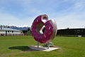
The "Springfield Doughnut"

St Peter's church

Rewi Alley memorial


References[]
- ^ a b c "ArcGIS Web Application". statsnz.maps.arcgis.com. Retrieved 16 October 2021.
- ^ a b c "Statistical area 1 dataset for 2018 Census". Statistics New Zealand. March 2020. 7026673.
- ^ "Springfield | NZETC". nzetc.victoria.ac.nz. Retrieved 8 November 2021.
- ^ "Springfield | NZETC". nzetc.victoria.ac.nz. Retrieved 8 November 2021.
- ^ a b Taonga, New Zealand Ministry for Culture and Heritage Te Manatu. "Darfield district". teara.govt.nz. Retrieved 8 November 2021.
- ^ "Springfield | NZHistory, New Zealand history online". nzhistory.govt.nz. Retrieved 8 November 2021.
- ^ "The Springfield Store and Cafe, dubbed NZ's rudest cafe, under offer". Stuff. 21 September 2019. Retrieved 21 September 2020.
- ^ kurt.bayer@nzherald.co.nz @KurtBayerNZME, Kurt Bayer NZ Herald reporter based in Christchurch (1 July 2019). "Owners of NZ's 'rudest cafe' Springfield Store and Cafe in hiding". NZ Herald. ISSN 1170-0777. Retrieved 21 September 2020.
- ^ "'Rudest' cafe, Springfield Store & Cafe, under new ownership". Otago Daily Times Online News. 16 October 2019. Retrieved 21 September 2020.
- ^ "New Zealand's 'rudest' cafe gets new owners". Newshub. Retrieved 21 September 2020.
- ^ "Police visit 'rudest cafe in New Zealand' after multiple complaints". Newshub. Retrieved 21 September 2020.
- ^ Herald, Khalia Strong, NZ. "New Zealand's 'rudest' cafe under new ownership". ZB. Retrieved 21 September 2020.
- ^ "New Zealand's 'rudest cafe' facing closure – report". www.msn.com. Retrieved 21 September 2020.
- ^ "Could this be the worst cafe in the world? | Gene Marks". the Guardian. 5 July 2019. Retrieved 21 September 2020.
- ^ "Police called over complaints about the café labelled New Zealand's rudest". au.news.yahoo.com. Retrieved 21 September 2020.
- ^ Eleven, Beck (28 September 2009). "D'oh! Springfield's giant Simpsons doughnut gets toasted". The Press. Retrieved 22 November 2009.
 Doughnut on display in Springfield, New Zealand at Wikinews
- ^ "New doughnut for Springfield". The Press. 1 July 2012. Retrieved 8 January 2013.
- ^ "Midland Rail Heritage Trust Website".
- ^ Wilson, John (17 August 2015). "Te Ara, the encyclopedia of New Zealand". Te Ara.
{{cite web}}: CS1 maint: url-status (link) - ^ "Contracting firm saves Springfield homes after digging out raging water race". Stuff. 31 May 2021. Retrieved 3 June 2021.
- ^ "Selwyn District Council". Selwyn District Council. Retrieved 3 June 2021.
- ^ "Four of New Zealand's most underrated ski towns". Stuff. 18 June 2021. Retrieved 19 June 2021.
- ^ "Population estimate tables - NZ.Stat". Statistics New Zealand. Retrieved 22 October 2021.
- ^ a b "Statistical area 1 dataset for 2018 Census". Statistics New Zealand. March 2020. Torlesse (333700). 2018 Census place summary: Torlesse
- ^ "Selwyn Electorate Profile – New Zealand Parliament". www.parliament.nz. Retrieved 13 October 2020.
- ^ "Selwyn District Council". Selwyn District Council. Retrieved 13 October 2020.
- ^ Education Counts: Springfield School
- ^ "New Zealand Schools Directory". New Zealand Ministry of Education. Retrieved 22 December 2021.
- ^ "Welcome - 150th Jubilee". Springfield School. Retrieved 16 October 2021.
External links[]
![]() Media related to Springfield, New Zealand at Wikimedia Commons
Media related to Springfield, New Zealand at Wikimedia Commons
- Selwyn District
- Populated places in Canterbury, New Zealand