Nirit
Nirit
נִירִית | |
|---|---|
 | |
| Etymology: Ridolfia segetum | |
 Nirit | |
| Coordinates: 32°8′38.04″N 34°58′58.79″E / 32.1439000°N 34.9829972°ECoordinates: 32°8′38.04″N 34°58′58.79″E / 32.1439000°N 34.9829972°E | |
| Country | |
| District | Central |
| Council | Drom HaSharon |
| Affiliation | HaMerkaz HaHakla'i |
| Founded | 1982 |
| Population (2019)[1] | 926 |
| Website | http://www.nirit.org.il/ |


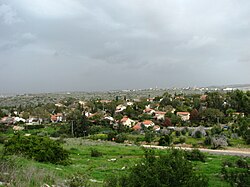
Nirit (Hebrew: נִירִית) is a community settlement in central Israel. Located near Matan and the Horshim forest, it falls under the jurisdiction of Drom HaSharon Regional Council. In 2019 it had a population of 926.[1]
Etymology[]

Nirit was founded on January 19, 1982[2] and was named after an indigenous plant, Ridolfia segetum, growing nearby. It expanded twice, once in 1986–1988 and again in 2000. Until 1986 there were only 15 families in temporary buildings, and nowadays it grew to about 240 families. In 2005 a new neighborhood named was built adjacent to Nirit. This neighborhood is located just outside (east of) the Green Line, actually belongs to the settlement Alfei Menashe, but in reality merged with Nirit for all intent and purpose.
The community is managed by elected committees, whose members are volunteers.
The communal character of Nirit is expressed by an active cultural life, events, and close ties between the residents.
Notable residents[]
- Tamir Pardo (b. 1953), former Director of the Mossad
References[]
- ^ a b "Population in the Localities 2019" (XLS). Israel Central Bureau of Statistics. Retrieved 16 August 2020.
- ^ Nirit - The Beginning Nirit (in Hebrew)
External links[]
- Official website (in Hebrew)
- Drom HaSharon Regional Council
- Community settlements
- Populated places established in 1982
- Populated places in Central District (Israel)
- 1982 establishments in Israel