Nitta Yuma, Mississippi
Nitta Yuma, Mississippi | |
|---|---|
 | |
 Nitta Yuma | |
| Coordinates: 33°01′27″N 90°50′57″W / 33.02417°N 90.84917°WCoordinates: 33°01′27″N 90°50′57″W / 33.02417°N 90.84917°W | |
| Country | United States |
| State | Mississippi |
| County | Sharkey |
| Elevation | 112 ft (34 m) |
| Time zone | UTC-6 (Central (CST)) |
| • Summer (DST) | UTC-5 (CDT) |
| Area code(s) | 662 |
| GNIS feature ID | 674927[1] |


Nitta Yuma is a census-designated place and unincorporated community located in Sharkey County, Mississippi, United States.[1] Nitta Yuma is located along U.S. Route 61, approximately four miles north of Anguilla.
Nitta Yuma is a name derived from the Choctaw language purported to mean "mixed with bear".[2]
Climate[]
The climate in this area is characterized by relatively high temperatures and evenly distributed precipitation throughout the year. According to the Köppen Climate Classification system, Nitta Yuma has a Humid subtropical climate, abbreviated "Cfa" on climate maps.[3]
Education[]
It is a part of the South Delta School District,[4] which operates South Delta High School.
Gallery[]

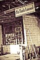
An old Nitta Yuma gas station. Picture taken while driving up 61 North


References[]
- ^ a b "Nitta Yuma, Mississippi". Geographic Names Information System. United States Geological Survey.
- ^ Baca, Keith A. (2007). Native American Place Names in Mississippi. University Press of Mississippi. p. 64. ISBN 978-1-60473-483-6.
- ^ Climate Summary for Nitta Yuma
- ^ "2020 CENSUS - SCHOOL DISTRICT REFERENCE MAP: Sharkey County, MS" (PDF). U.S. Census Bureau. Retrieved 2021-06-09.
External links[]
Municipalities and communities of Sharkey County, Mississippi, United States | ||
|---|---|---|
| City |  | |
| Towns | ||
| CDPs | ||
| Other communities | ||
| ||
This Sharkey County, Mississippi state location article is a stub. You can help Wikipedia by . |
- Unincorporated communities in Sharkey County, Mississippi
- Unincorporated communities in Mississippi
- Census-designated places in Sharkey County, Mississippi
- Mississippi Delta region geography stubs