Nittedal
Nittedal kommune | |
|---|---|
 | |
 Coat of arms  Viken within Norway | |
 Nittedal within Viken | |
| Coordinates: 60°4′23″N 10°52′20″E / 60.07306°N 10.87222°ECoordinates: 60°4′23″N 10°52′20″E / 60.07306°N 10.87222°E | |
| Country | Norway |
| County | Viken |
| District | Romerike |
| Administrative centre | Rotnes |
| Government | |
| • Mayor (2011) | Hilde Thorkildsen (Ap) |
| Area | |
| • Total | 186 km2 (72 sq mi) |
| • Land | 179 km2 (69 sq mi) |
| Area rank | 338 in Norway |
| Population (2006 Q2) | |
| • Total | 19,722 |
| • Rank | 47 in Norway |
| • Density | 108/km2 (280/sq mi) |
| • Change (10 years) | 18.0% |
| Demonym(s) | Nittedøl or Nittedøling[1] |
| Time zone | UTC+01:00 (CET) |
| • Summer (DST) | UTC+02:00 (CEST) |
| ISO 3166 code | NO-3031 |
| Official language form | Bokmål[2] |
| Website | www |

Nittedal is a municipality and city in Akershus in Viken county, Norway. It is part of the traditional region of Romerike. The administrative centre of the municipality is the village of Rotnes.
The parish of Nitedal was established as a municipality on 1 January 1838 (see formannskapsdistrikt).
Name[]
The name (Old Norse: Nitjudalr) is an old district name. The first element is the genitive case of the river name Nitja (now Nitelva) and the last element is dalr which means "valley" or "dale". The meaning of the river name is unknown. Prior to 1918, the name was written "Nittedalen".
Coat-of-arms[]
The coat-of-arms is from modern times. They were granted on 23 January 1987. The arms show the two silver lines running in a bend sinister direction on a green background. They represent the main transportation lines that run through the municipality from Oslo to other parts of the country: the main highway and the railroad, they also can represent skiing tracks, an old winter transportation method. At the same time the two lines symbolize matches, as one of Norway's oldest match factories was founded in Nittedal. The lines also symbolize tree logs, as forestry is of great importance for the local economy.[3][4]
Geography[]

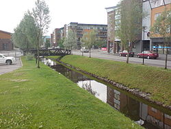
Nittedal lies directly northeast of Oslo and serves as a suburb to the capital. It is located on both sides of the Nitelva river. The southernmost population centre is Hagan. Further north lie the centres of Slattum, Rotnes, Åneby, Grønvoll, Varingskollen, and Hakadal.
History[]
In 1902 the construction of the Gjøvik Line reached the west side of Nittedal, from Oslo and thru the forest.[5]
Demography[]
| Ancestry | Number |
|---|---|
| 462 | |
| 329 | |
| 303 | |
| 241 | |
| 197 | |
| 178 | |
| 139 | |
| 103 | |
| 103 | |
| 94 |
Administration[]
Mayor Hilde Thorkildsen is on suspension from her position, and she is on trial for corruption (as of 2021's third quarter).[7]
Sister cities[]
The following cities are twinned with Nittedal:[8]
 - Fredensborg, Region Hovedstaden, Denmark
 - Håbo, Uppsala County, Sweden
 - Ingå, Uusimaa, Finland
Notable people[]

This list includes people who were born or have resided in Nittedal:
- Peter Østbye (1855 in Nittedal - 1943) a philologist and academic administrator
- Svend Rasmussen Svendsen (1864 in Nittedal – 1945) a Norwegian American impressionist artist
- Hans Prydz (1868–1957) a physician and Mayor of Nittedal 1913/22 & 1928/34
- Gunnar Haarstad (1916 in Nittedal – 1992) a jurist, police officer, a resistance member during World War II, and head of the Norwegian Police Security Service for fifteen years
- Tor Brustad (1926 in Nittedal – 2016) a Norwegian biophysicist
- Nils Vogt (1926 in Hakadal – 2000) a Norwegian civil servant and diplomat
- Kjell Magne Yri (born 1943) a Norwegian priest and linguist, lives in Nittedal
- Inge Solli (born 1959) a Norwegian politician, deputy county Mayor of Akershus
- Ib Thomsen (born 1961) politician
- Jarle Bernhoft (born 1976 in Nittedal) stage name Bernhoft, singer, multi-instrumentalist, composer and lyricist
- Marte Wexelsen Goksøyr (born 1982 in Nittedal) an actress, public speaker, writer and public debater with Down syndrome

Sport[]
- Hroar Elvenes (1932 in Hakadal – 2014) a speed skater, competed in four Winter Olympics
- Odd Martinsen (born 1942) cross-country skier, multiple Olympic medallist, father of Bente Skari
- Terje Thorslund (born 1945) a former Norwegian champion javelin thrower
- Bente Skari (born 1972 in Nittedal) cross-country skier, multiple Olympic medallist
- Hanne Staff (born 1972 in Nittedal) an orienteering athlete
- Astrid Wanja Brune Olsen (born 1999 in Nittedal) a Norwegian tennis player
References[]
- ^ "Navn på steder og personer: Innbyggjarnamn" (in Norwegian). Språkrådet.
- ^ "Forskrift om målvedtak i kommunar og fylkeskommunar" (in Norwegian). Lovdata.no.
- ^ Norske Kommunevåpen (1990). "Nye kommunevåbener i Norden". Retrieved 2008-12-20.
- ^ "Nittedals kommunevåpen" (in Norwegian). Nittedal kommune. Retrieved 2008-12-20.[permanent dead link]
- ^ https://snl.no/Nittedal "Etter at Gjøvikbanen i 1902 var ført fra Oslo over skogen til vestsiden av Nittedal, vokste det her opp villabebyggelser, særlig ved Nittedal stasjon."
- ^ "Immigrants and Norwegian-born to immigrant parents, by immigration category, country background and percentages of the population". ssb.no. Retrieved 25 June 2017.
- ^ https://www.nrk.no/osloogviken/ordforer-tiltalt-for-grov-korrupsjon-_-politiets-telefonavlytting-blir-bevis-i-retten-1.15621948. Retrieved 31 August 2021
- ^ "Lenker" (in Norwegian). Nittedal kommune. Retrieved 2008-12-20.[permanent dead link]
External links[]
 Media related to Nittedal at Wikimedia Commons
 The dictionary definition of Nittedal at Wiktionary
- Municipal fact sheet from Statistics Norway
 Akershus travel guide from Wikivoyage
- Varingen: the local newspaper
- Population changes from 1951 onwards
| show Places adjacent to Nittedal |
|---|
| hide | |||||||||||||||||||||||
|---|---|---|---|---|---|---|---|---|---|---|---|---|---|---|---|---|---|---|---|---|---|---|---|
 | Towns and cities |
|  | ||||||||||||||||||||
| Municipalities |
| ||||||||||||||||||||||
| show Authority control |
|---|
- Nittedal
- Municipalities of Akershus
- Municipalities of Viken