Nooseneck, Rhode Island
Nooseneck, Rhode Island | |
|---|---|
Village | |
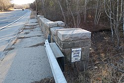 Nooseneck Hollow Bridge 36 | |
 Nooseneck | |
| Coordinates: 41°37′15″N 71°38′08″W / 41.62083°N 71.63556°WCoordinates: 41°37′15″N 71°38′08″W / 41.62083°N 71.63556°W | |
| Country | United States |
| State | Rhode Island |
| County | Kent |
| Town | West Greenwich |
| Elevation | 407 ft (124 m) |
| Time zone | UTC-5 (Eastern (EST)) |
| • Summer (DST) | UTC-4 (EDT) |
| Area code(s) | 401 |
| GNIS feature ID | 1218250[1] |


Nooseneck is a village in Kent County, Rhode Island, United States, in the rural town of West Greenwich. Nooseneck is located on Rhode Island Route 3 near Interstate 95. The Nooseneck River passes through the village, where Interstate 95 crosses over it.
References[]
- ^ "US Board on Geographic Names". United States Geological Survey. 2007-10-25. Retrieved 2008-01-31.
Municipalities and communities of Kent County, Rhode Island, United States | ||
|---|---|---|
| City |  | |
| Towns | ||
| CDP | ||
| Villages | ||
| ||
This Rhode Island state location article is a stub. You can help Wikipedia by . |
Categories:
- Villages in Kent County, Rhode Island
- West Greenwich, Rhode Island
- Providence metropolitan area
- Villages in Rhode Island
- Rhode Island geography stubs