North Carolina Highway 172
 | ||||
|---|---|---|---|---|
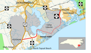 Open segments of NC 172 in solid red; closed segment in dashed red | ||||
| Route information | ||||
| Maintained by NCDOT | ||||
| Length | 25.2 mi[1] (40.6 km) | |||
| Existed | 1940s[2]–present | |||
| Major junctions | ||||
| South end | ||||
| North end | ||||
| Location | ||||
| Counties | Onslow | |||
| Highway system | ||||
| ||||
| ||||
North Carolina Highway 172 (NC 172) is a primary state highway in the U.S. state of North Carolina; it is entirely in Onslow County. It is also unique in that over half of this highway travels through Marine Corps Base Camp Lejeune on federal grounds.
Route description[]
The entire routing of NC 172 is in Onslow County split in the middle by Camp Lejeune. The route's southern terminus is at US 17 in the unincorporated community of , located between Holly Ridge and Wilmington. The road heads east-northeast through a mix of forest land and small houses towards the community of Sneads Ferry. About 4 miles (6.4 km) from its terminus, it intersects NC 210. It then starts to bend towards the north forming the border of the Sneads Ferry census-designated place. The Lakeside Drive/Old Ferry Road intersection is the last intersection that is accessible by the public along the southern segment of NC 172. North of there, the road crosses the New River before reaching the gate to Camp Lejeune. Through Camp Lejeune, the closed road heads east then north through mostly forested lands of the base. The road reopens at its intersection with Bear Creek Road, just north of a gate. On this segment of the road, NC 172 heads north passing forestland on the west side of the road and some houses on the east. The signed highway ends at a signalized intersection with NC 24 in near Hubert.[1]
History[]
April 2007: Travel through the Camp Lejeune section of the highway is restricted to vehicles with U.S. Department of Defense decals as a security measure.[3]
Junction list[]
The entire route is in Onslow County.
| Location | mi | km | Destinations | Notes | |
|---|---|---|---|---|---|
| 0.0 | 0.0 | ||||
| | 4.0 | 6.4 | |||
| | 6.9– 22.1 | 11.1– 35.6 | Marine Corps Base Camp Lejeune Road closed to public | ||
| 25.2 | 40.6 | ||||
| 1.000 mi = 1.609 km; 1.000 km = 0.621 mi | |||||
References[]
| ( • help)
|
- ^ a b Google (April 12, 2016). "North Carolina Highway 172" (Map). Google Maps. Google. Retrieved April 12, 2016.
- ^ NCRoads - NC 172 Archived February 16, 2007, at the Wayback Machine[self-published source]
- ^ [1][dead link]
This North Carolina road or road transport-related article is a stub. You can help Wikipedia by . |
- State highways in North Carolina
- Transportation in Onslow County, North Carolina
- North Carolina road stubs
