Northford, Connecticut
Northford, Connecticut | |
|---|---|
 Northford | |
| Coordinates: 41°23′31″N 72°47′31″W / 41.39194°N 72.79194°WCoordinates: 41°23′31″N 72°47′31″W / 41.39194°N 72.79194°W | |
| Country | |
| State | Connecticut |
| County | New Haven |
| Town | North Branford |
| Area | |
| • Total | 20.71 km2 (8.00 sq mi) |
| • Land | 20.68 km2 (7.98 sq mi) |
| • Water | 0.03 km2 (0.01 sq mi) |
| Elevation | 60 m (210 ft) |
| Time zone | UTC-5 (Eastern (EST)) |
| • Summer (DST) | UTC-4 (EDT) |
| ZIP Code | 06472 |
| Area code(s) | 203/475 |
| FIPS code | 09-54450 |
| GNIS feature ID | 2805986[2] |
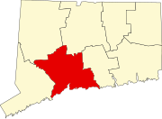
Northford is a census-designated place (CDP) comprising the primary village and surrounding residential and rural land in the town of North Branford, New Haven County, Connecticut, United States. It is in the northern part of the town, bordered to the west by the town of North Haven, to the east by the town of Guilford, and to the north by the town of Wallingford, all in New Haven County. It is bordered to the northeast by the town of Durham in Middlesex County. In 2002, 230 acres (93 ha) of the central village of Northford were designated as the Northford Center Historic District.
Northford was first listed as a CDP prior to the 2020 census.
References[]
- ^ "2020 U.S. Gazetteer Files – Connecticut". United States Census Bureau. Retrieved April 14, 2021.
- ^ a b "Northford Census Designated Place". Geographic Names Information System. United States Geological Survey.
Categories:
- Connecticut geography stubs
- Census-designated places in New Haven County, Connecticut
- Census-designated places in Connecticut


