Norwood Memorial Airport
Norwood Memorial Airport | |||||||||||||||
|---|---|---|---|---|---|---|---|---|---|---|---|---|---|---|---|
 | |||||||||||||||
| Summary | |||||||||||||||
| Airport type | Public | ||||||||||||||
| Owner | Town of Norwood | ||||||||||||||
| Location | Norwood, Massachusetts | ||||||||||||||
| Elevation AMSL | 49 ft / 15 m | ||||||||||||||
| Coordinates | 42°11′26″N 071°10′23″W / 42.19056°N 71.17306°W | ||||||||||||||
| Website | Official website | ||||||||||||||
| Map | |||||||||||||||
 OWD | |||||||||||||||
| Runways | |||||||||||||||
| |||||||||||||||
| Statistics (2006) | |||||||||||||||
| |||||||||||||||


Norwood Memorial Airport (IATA: OWD, ICAO: KOWD, FAA LID: OWD)[2][3] is a public airport 2 mi (1.7 nmi; 3.2 km) east of Norwood, in Norfolk County, Massachusetts, United States.[1] It is home to the offices of prominent local business people and several maintenance facilities.
As Outlying Landing Field Norwood, the airfield was a Naval Outlying Landing Field located in Norwood, Massachusetts operational from 1942 to 1945. It existed as an outlying field of Naval Air Station Squantum and was used by student pilots to gain flight experience on its two 4,000 ft (1,200 m) runways.[4] The 1946 chart shows it as a civil airfield. It took the place of the former Boston Metropolitan Airport in Canton, Massachusetts.[5]
Facilities[]
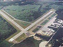
Norwood Memorial Airport covers 688 acres (278 ha) and has two runways:[1]
- 10/28: 3,995 ft × 75 ft (1,218 m × 23 m), asphalt
- 17/35: 4,008 ft × 100 ft (1,222 m × 30 m), asphalt
In the year ending 1 January 2006 the airport had 100,000 aircraft operations, average 273 per day: 77% general aviation, 22% air taxi and 1% military.[1]
246 aircraft are based at this airport: 81% single engine, 12% multi-engine, 4% jet aircraft and 2% helicopters.[1]
The airport has two flight schools and Flight Level Aviation as an FBO. Charter services operate commonly out of the airport.
Due to federal budget cuts the air traffic control tower was to close in 2013, but FAA funding was restored before closure took place.[6]
Airlines and destinations[]
This section needs to be updated. (January 2022) |
| Airlines | Destinations |
|---|---|
| Southern Airways Express | Nantucket[7] |
Incidents[]

On 4 June 2007 a Mooney M-20-P crashed into the woods south of the airport while on final approach. One person was killed.[8]
In March 2010 the airport was closed due to severe flooding.[9] Coordinates: 42°11′14″N 71°10′33″W / 42.1873°N 71.1759°W
References[]
- ^ a b c d e FAA Airport Form 5010 for OWD PDF, effective 2007-03-15
- ^ "Codes - Airline and airport codes search". IATA. Retrieved 2012-10-22.
- ^ "Norwood Memorial". NFDC. FAA. Retrieved 2012-10-22.

- ^ "Massachusetts Naval Air Bases, Coast Guard Bases, Military & Auxiliary Air Fields 1923-1945". Massachusetts Aviation Historical Society. 2011. Retrieved 26 June 2014.
- ^ "Abandoned and Little-Known Airfields - Massachusetts, Southwest Boston Area - Massachusetts Air Terminal & Arena / Canton Airport / Massachusetts Air Terminal / Boston Metropolitan Airport, Canton, MA".
- ^ Laing, Keith (10 May 2013). "FAA relents on flight tower closures; GOP declares sequester skirmish win". The Hill. Retrieved 11 November 2014.
- ^ Palma, Kristi (28 May 2019). "Southern Airways Express will begin service to Nantucket from 3 New England airports". Boston.com. Retrieved 7 June 2019.
- ^ "Woman killed in plane crash near Norwood Airport". WBZ NewsRadio 1030. 2007-06-04.
- ^ "DOT: Norwood Airport a flooding risk". Norwood Transcript and Bulletin. 15 March 2010. Retrieved 3 January 2011.
External links[]
- Norwood Memorial Airport (official site)
- Flight Level Norwood
- FAA Airport Diagram (PDF), effective January 27, 2022
- Resources for this airport:
- FAA airport information for OWD
- AirNav airport information for KOWD
- ASN accident history for OWD
- FlightAware airport information and live flight tracker
- NOAA/NWS weather observations: current, past three days
- SkyVector aeronautical chart, Terminal Procedures
This article about a building or structure in Massachusetts is a stub. You can help Wikipedia by . |
This article about an airport in Massachusetts is a stub. You can help Wikipedia by . |
- Norwood, Massachusetts
- Airports in Norfolk County, Massachusetts
- Massachusetts building and structure stubs
- Northeastern United States airport stubs
- Massachusetts transportation stubs
- Closed installations of the United States Navy