Notre-Dame-du-Portage, Quebec
show This article may be expanded with text translated from the corresponding article in French. (March 2019) Click [show] for important translation instructions. |
Notre-Dame-du-Portage | |
|---|---|
Municipality | |
 | |
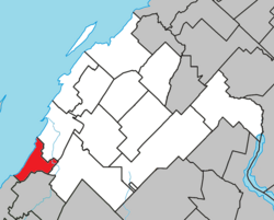 Location within Rivière-du-Loup RCM | |
 Notre-Dame-du-Portage Location in eastern Quebec | |
| Coordinates: 47°46′N 69°37′W / 47.767°N 69.617°WCoordinates: 47°46′N 69°37′W / 47.767°N 69.617°W[1] | |
| Country | |
| Province | |
| Region | Bas-Saint-Laurent |
| RCM | Rivière-du-Loup |
| Constituted | July 19, 1856 |
| Government | |
| • Mayor | Vincent More |
| • Federal riding | Montmagny—L'Islet—Kamouraska—Rivière-du-Loup |
| • Prov. riding | Rivière-du-Loup-Témiscouata |
| Area | |
| • Total | 115.90 km2 (44.75 sq mi) |
| • Land | 39.91 km2 (15.41 sq mi) |
| Population | |
| • Total | 1,193 |
| • Density | 29.9/km2 (77/sq mi) |
| • Pop 2006-2011 | |
| • Dwellings | 686 |
| Postal code(s) | G0L 1Y0 |
| Area code(s) | 418 and 581 |
| Highways | |
| Website | www |

Notre-Dame-du-Portage is a municipality[2] in the Canadian province of Quebec located at the edge of the Saint Lawrence River in the Bas-Saint-Laurent region. It is part of the Rivière-du-Loup Regional County Municipality and home to the Riviere-du-Loup Golf Club.
Main sights[]
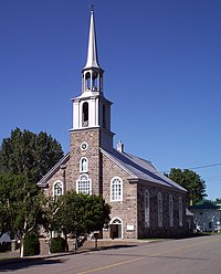
Notre-Dame-du-Portage is a member of the Association of the Most Beautiful Villages of Quebec. Its Roman Catholic Church was constructed in 1859.
See also[]
References[]
- ^ Reference number 390724 of the Commission de toponymie du Québec (in French)
- ^ Jump up to: a b c Geographic code 12080 in the official Répertoire des municipalités (in French)
- ^ Jump up to: a b "(Code 2412080) Census Profile". 2011 census. Statistics Canada. 2012.
External links[]
- Notre-Dame-du-Portage at the Association of the Most Beautiful Villages of Quebec
- Notre-Dame-du-Portage, Quebec Community Demographics from Industry Canada
External links[]
 Media related to Notre-Dame-du-Portage at Wikimedia Commons
| show Adjacent Municipal Subdivisions |
|---|
| hide | |
|---|---|
| Cities & Towns | |
| Municipalities | |
| Parishes | |
| |
| show Authority control |
|---|
Categories:
- Incorporated places in Bas-Saint-Laurent
- Municipalities in Quebec