Nyáregyháza
Nyáregyháza | |
|---|---|
Village | |
 | |
 Flag  Coat of arms | |
 Nyáregyháza Location of Nyáregyháza | |
| Coordinates: 47°15′42″N 19°30′32″E / 47.26156°N 19.50895°E | |
| Country | Hungary |
| Region | Central Hungary |
| County | Pest |
| District | Monor |
| Area | |
| • Total | 32 km2 (12 sq mi) |
| Population (1 January 2018)[1] | |
| • Total | 3,727 |
| • Density | 120/km2 (300/sq mi) |
| Time zone | UTC+1 (CET) |
| • Summer (DST) | UTC+2 (CEST) |
| Postal code | 2723 |
| Area code | (+36) 29 |
| KSH code | 23038[2] |
| Website | www |

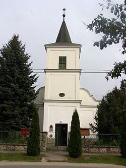
Nyáregyháza is a village in Pest county, Hungary.
References[]
- ^ "Gazetteer of Hungary, 1st January 2018" (in Hungarian). Hungarian Central Statistical Office. 3 September 2018. Retrieved 4 September 2018.
- ^ Nyáregyháza at the Hungarian Central Statistical Office (Hungarian).
Coordinates: 47°15′N 19°30′E / 47.250°N 19.500°E


| show Authority control |
|---|
This Pest County location article is a stub. You can help Wikipedia by . |
Categories:
- Populated places in Pest County
- Pest County geography stubs