Tököl
Tököl | |
|---|---|
 The Chapel of St Anna | |
 Flag  Coat of arms | |
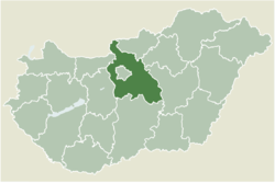 | |
 Tököl Location of Tököl | |
| Coordinates: 47°19′13″N 18°58′02″E / 47.32030°N 18.96711°ECoordinates: 47°19′13″N 18°58′02″E / 47.32030°N 18.96711°E | |
| Country | |
| County | Pest |
| Area | |
| • Total | 38.49 km2 (14.86 sq mi) |
| Population (2004) | |
| • Total | 9,337 |
| • Density | 242.58/km2 (628.3/sq mi) |
| Time zone | UTC+1 (CET) |
| • Summer (DST) | UTC+2 (CEST) |
| Postal code | 2316 |
| Area code(s) | 24 |

Tököl (Serbo-Croatian: Tukulja) is a town in Pest County, Hungary.

Aerialphotography from Tököl
Demography[]
The majority of residents are Hungarians, with a minority of Bunjevci.
Hungarian Uprising[]
An Budapest-Tököl airfield (47 20 35 N / 18 59 20 E) was built during World War II, which was to become a Soviet military base. During the Hungarian Uprising, Pál Maléter, as Defence Minister for the Imre Nagy government, went to negotiate with the Soviet military presence and was arrested during the negotiations.
Notable residents[]
- Pál Hoffman, politician
- István Szilágyi, handball player
External links[]
- Street map (in Hungarian)


| Authority control |
|---|
This Pest County location article is a stub. You can help Wikipedia by . |
Categories:
- Populated places in Pest County
- Croatian communities in Hungary
- Serb communities in Hungary
- Pest County geography stubs