Obernheim
Obernheim | |
|---|---|
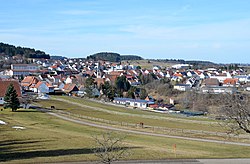 View across Obernheim | |
 Coat of arms | |
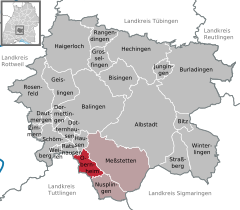
show Location of Obernheim within Zollernalbkreis district | |
 Obernheim | |
| Coordinates: 48°09′45″N 08°51′42″E / 48.16250°N 8.86167°ECoordinates: 48°09′45″N 08°51′42″E / 48.16250°N 8.86167°E | |
| Country | Germany |
| State | Baden-Württemberg |
| Admin. region | Tübingen |
| District | Zollernalbkreis |
| Government | |
| • Mayor | Josef Ungermann |
| Area | |
| • Total | 15.02 km2 (5.80 sq mi) |
| Elevation | 897 m (2,943 ft) |
| Population (2020-12-31)[1] | |
| • Total | 1,449 |
| • Density | 96/km2 (250/sq mi) |
| Time zone | UTC+01:00 (CET) |
| • Summer (DST) | UTC+02:00 (CEST) |
| Postal codes | 72364 |
| Dialling codes | 07436 |
| Vehicle registration | BL |
| Website | www |


Obernheim is a municipality of the Zollernalbkreis district of Baden-Württemberg, Germany.
History[]
Obernheim became a possession of the Kingdom of Württemberg in 1805 and was assigned to . Five years later, in 1810, it was reassigned to , which was merged into in 1938. Obernheim grew and industrialized after the Second World War, first expanding in the 1950s to the north-east and west, and then in the 1970s to the north once more. As part of the , Landkreis Balingen was dissolved and Obernheim was assigned to the newly-created Zollernalb district. There was further municipal growth to the northeast in the 1980s and 1990s.[2]
Geography[]
The municipality (Gemeinde) of Obernheimof is located along the southern edge Zollernalb district of Baden-Württemberg, one of the Federal Republic of Germany's 16 States. It lies along the border with Tuttlingen district and the western edge of the , between the Upper and Lower Bära rivers, in the . Elevation above sea level ranges in the municipality from a high of 988 meters (3,241 ft) Normalnull (NN) to a low of 751 meters (2,464 ft) NN.[2]
A portion of the Federally-protected nature reserve is located in Obernheim's municipal area.[2]
Coat of arms[]
Obernheim's coat of arms is a field of white crossed by a single blue bar. This pattern was adapted from the personal blazon of Johann von Obernheim, a local 14th century nobleman, and was approved for official use by the provisional post-WWII Württemberg-Hohenzollern government on 27 October 1950. A corresponding flag was issued on 15 January 1982.[2]
Transportation[]
Obernheim was connected to the Heuberg Railway until its station was closed in 1996. Local public transportation is provided by the .[2]
References[]
- ^ "Bevölkerung nach Nationalität und Geschlecht am 31. Dezember 2020". Statistisches Landesamt Baden-Württemberg (in German). June 2021.
- ^ Jump up to: a b c d e "Nusplingen". LEO-BW (in German). Baden-Württemberg. Retrieved 17 July 2020.
External links[]
- Official website
 (in German)
| show Towns and municipalities in Zollernalb district |
|---|
| Authority control |
|---|
- Municipalities in Baden-Württemberg
- Württemberg