Ochota
Ochota | |
|---|---|
 Physics' Campus of Warsaw University in Ochota | |
 Coat of arms | |
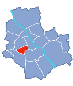
 Location of Ochota within Warsaw | |
| Country | |
| Voivodeship | Masovian |
| County/City | Warsaw |
| Government | |
| • Mayor | Katarzyna Łęgiewicz |
| Area | |
| • Total | 9.72 km2 (3.75 sq mi) |
| Population (2019) | |
| • Total | 82,774[1] |
| Time zone | UTC+1 (CET) |
| • Summer (DST) | UTC+2 (CEST) |
| Area code(s) | +48 22 |
| Website | urzadochota.waw.p |
Ochota (Polish pronunciation: [ɔˈxɔta]) is a district of Warsaw, Poland, located in the central part of the Polish capital city's urban agglomeration.
The biggest housing estates of Ochota are:
- Kolonia Lubeckiego
- Kolonia Staszica
- Filtry
- Rakowiec
- Szosa Krakowska
- Szczęśliwice
- Osiedle Oaza
Neighbourhoods within the district[]
- Stara Ochota
- Filtry
- Rakowiec
- Szczęśliwice
See also[]
References[]
- ^ "Powierzchnia i ludność w przekroju terytorialnym w 2019 roku. Tabl. 21 Powierzchnia, ludność oraz lokaty według gmi". stat.gov.pl. Główny Urząd Statystyczny. Retrieved 2 September 2020.
External links[]
- Official website

 Media related to Ochota at Wikimedia Commons
 Ochota travel guide from Wikivoyage
Coordinates: 52°12′59″N 20°58′52″E / 52.21639°N 20.98111°E
Categories:
- Ochota
- Districts of Warsaw
- Warsaw geography stubs
