Warsaw metropolitan area
This article needs additional citations for verification. (January 2017) |
Warsaw metropolitan area
Aglomeracja Warszawska (Polish) | |
|---|---|
 | |
 | |
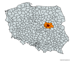 Map of the Warsaw metropolitan area | |
| Country | |
| Region | Masovian Voivodeship |
| Largest city | Warsaw |
| Area | |
| • Metro | 6,100 km2 (2,355 sq mi) |
| Population | |
| • Metro | 3,053,104 |
| • Metro density | 500.5/km2 (1,296.4/sq mi) |
| Time zone | UTC+1 (CET) |
| Website | http://omw.um.warszawa.pl/ |
The Warsaw metropolitan area (known in Polish as: Aglomeracja Warszawska) is the metropolitan area of Warsaw, the capital of Poland. The metropolitan area covers ten counties[1] in the Masovian Voivodeship, with an area of 6,100 km²[2] and a population of around 3 million in 2019.[3]
The largest cities or towns within the metropolitan area are Warsaw, Pruszków, Legionowo, Otwock, Mińsk Mazowiecki, Piaseczno and Wołomin.
Public transport in the metropolitan area is served by the Warsaw Transport Authority (Zarząd Transportu Miejskiego).
See also[]
References[]
External links[]
- Warsaw development strategy until 2010 (archived)
- http://urbact.eu/fileadmin/subsites/civitas/Mazovia_UR_policies_TS.pdf
Coordinates: 52°14′00″N 21°01′00″E / 52.233333°N 21.016667°E

Categories:
- Geography of Warsaw
- Metropolitan areas of Poland
- Poland-related lists
- Warsaw-related lists