Ohio State Route 361
 | ||||
|---|---|---|---|---|
 | ||||
| Route information | ||||
| Maintained by ODOT | ||||
| Length | 4.67 mi[1] (7.52 km) | |||
| Major junctions | ||||
| West end | ||||
| East end | ||||
| Location | ||||
| Counties | Pickaway | |||
| Highway system | ||||
| ||||
| ||||
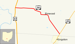
State Route 361 (SR 361, OH 361) is a 4.67-mile-long (7.52 km) long state highway entirely located within Pickaway Township, Pickaway County, Ohio. The route connects US 23 with SR 159 just north of Kingston.
Route description[]
The state highway begins at an unsignalized intersection with the divided US 23 in Pickaway Township. The two-lane road travels east through farmland though there are two S-curves that bring the route further south. In the unincorporated community of Elmwood, the road passes over a railroad via a bridge. After the railroad bridge, SR 361 curves to the southeast and passes through more farmland before ending at a skewed T-intersection with SR 159 about 0.2 miles (0.32 km) north of the Pickaway-Ross County line and the village of Kingston.[2]
History[]
A segment of modern-day SR 361 running about 1.6 miles (2.6 km) from US 23 to the Logan Elm State Memorial was first designated in 1932 as an unnumbered gravel road.[3][4][2] By 1934, the route received its number of SR 361.[5] The route was extended to its current length between US 23 and SR 159 circa 1937.[6] By 1948, the route was fully paved and has not changed since its first designation.[7]
Major intersections[]
The entire route is in Pickaway Township, Pickaway County.
| mi[1] | km | Destinations | Notes | ||
|---|---|---|---|---|---|
| 0.00 | 0.00 | ||||
| 4.67 | 7.52 | ||||
| 1.000 mi = 1.609 km; 1.000 km = 0.621 mi | |||||
References[]
Route map:

| ( • help)
|
- ^ a b Ohio Department of Transportation. "Technical Services Straight Line Diagrams" (PDF). Retrieved October 6, 2013.
- ^ a b Google (October 4, 2013). "Ohio State Route 361" (Map). Google Maps. Google. Retrieved October 4, 2013.
- ^ Map of Ohio Showing State Routes (MrSID) (Map). Cartography by ODHPW. Ohio Department of Highways and Public Works. 1931. Retrieved 2013-09-28.
- ^ Map of Ohio Showing State Routes (MrSID) (Map). Cartography by ODHPW. ODHPW. 1932. Retrieved 2013-09-28.
- ^ Map of Ohio Showing State Routes (MrSID) (Map). Cartography by ODHPW. ODHPW. 1934. Retrieved 2013-09-28.
- ^ Map of Ohio Showing State Routes (MrSID) (Map). Cartography by ODHPW. ODHPW. 1937. Retrieved 2013-09-28.
- ^ Map of Ohio Showing State Routes (MrSID) (Map). Cartography by ODHPW. ODHPW. 1948. Retrieved 2013-09-28.
- State highways in Ohio
- Transportation in Pickaway County, Ohio