Old Kent Road railway station

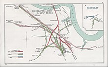
Old Kent Road was a railway station on the London, Brighton and South Coast Railway line in south London which took its name from the Old Kent Road on which it was located. The station opened on 13 August 1866[1][2] on a viaduct and bridge crossing the road at a junction with a line to London Bridge station and what became Surrey Quays station on the East London Line and Queens Road Peckham station on the South London Line. The station was renamed in 1870 to Old Kent Road and Hatcham. The passenger train service to East London was withdrawn on 1 June 1911 and the track was removed in 1912.[3] The station closed temporarily on 1 January 1917 during the First World War as an economy measure, but was never reopened after the end of the war.
Future[]
The reopening of the spur from Old Kent Road Junction to the East London Line in December 2012 allowed through services, as part of London Overground, a century after they were withdrawn. A new station named New Bermondsey is proposed to be situated about 700 metres north of the site of the former Old Kent Road station.[4][5] A possible Bakerloo line extension has also been proposed to stop at either Old Kent Road or Peckham Rye.[6][7]
References[]
- ^ Chronology of London Railways by H.V.Borley
- ^ London's Disused Stations by J.E.Connor
- ^ Londons Disused Stations Volume 6 by J.E.Connor
- ^ Google Image Result for http://www.arup.com/_assets/_img/image5974.jpg[dead link]
- ^ "Next steps Transport for London". Archived from the original on 22 January 2008.
- ^ Bakerloo Line extension TFL website
- ^ "Bakerloo line extension: Background to consultation" (PDF). Transport for London. September 2014. Retrieved 11 September 2016.
| Preceding station | Disused railways | Following station | ||
|---|---|---|---|---|
| Queen's Road Peckham | London, Brighton & South Coast Railway |
South Bermondsey |


- Railway stations in Great Britain opened in 1866
- Railway stations in Great Britain closed in 1917
- Former London, Brighton and South Coast Railway stations
- Disused railway stations in the London Borough of Southwark
- 1866 establishments in England