Old Woughton
| Old Woughton | |
|---|---|
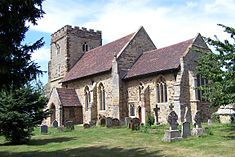 St Mary's parish church | |
 Old Woughton Mapping © OpenStreetMap | |
| OS grid reference | SP875378 |
| Civil parish |
|
| Unitary authority | |
| Ceremonial county | |
| Region | |
| Country | England |
| Sovereign state | United Kingdom |
| Post town | MILTON KEYNES |
| Postcode district | MK6 |
| Dialling code | 01908 |
| Police | Thames Valley |
| Fire | Buckinghamshire |
| Ambulance | South Central |
| UK Parliament | |
| Website | Old Woughton Parish Council website |


Old Woughton (/ˈwʊftən/ WUUF-tən) is a district and civil parish[1] in south central Milton Keynes, Buckinghamshire, England. The parish was established in April 2012 by the division into two parts of Woughton parish.[2] The original (undivided) civil parish was itself originally called "Woughton on the Green".[3][4]
Creation of the parish[]
The parish was created following a campaign by residents of Woughton parish who petitioned Milton Keynes Borough Council in 2010. The Council originally rejected the proposals, however it agreed to instigate a further review.[5] The proposal was reconsidered by Milton Keynes Council in November 2011 who decided to split the Woughton parish into two and establish a new parish from April 2012[6] The new parish was given the temporary name of 'Ouzel Valley' and elections to the parish council were held in May 2012. At the first meeting of the nine-member parish council on 9 May 2012 the name of Old Woughton Parish was adopted.[7]
Population[]
(The parish did not exist at the time of the 2011 Census so its population is included in the data for Woughton parish).
Geography[]
The parish includes the areas of Woughton on the Green, Woughton Park and Passmore. The boundaries of the parish run from the Netherfield Roundabout (H8/V8), south along the V8 (Marlborough Street) to a point where it intersects a redway north of Tinkers Bridge, then east along the redway to the Grand Union Canal, then south along the Canal to a point where it intersects H9 (Groveway), then along H9 (Groveway) to a point where it intersects the River Ouzel, then north along the River Ouzel to a point where it intersects H7 (Chaffron Way), then west along H7 (Chaffron Way) to a point where it intersects the Grand Union Canal, then south along the Grand Union Canal to a point where it intersects H8 (Standing Way), then west along H8 (Standing Way) to the Netherfield Roundabout (H8/V8).[7]
Woughton on the Green[]
Woughton on the Green is a traditional Buckinghamshire village that is now part of Milton Keynes. It gave its name to the parish of Woughton, of which it was a part until March 2012.
The village was originally just called "Woughton", but by 1750 it was already being referred to as "Wofton on the Green". It has been suggested that the suffix was added to distinguish the village from other nearby places with the same name. On the Green refers to the large grassy area that lay in the centre of the village: the traditional village green.
In the Domesday Book of 1086 Woughton on the Green was recorded as Ulchetone. This is an Anglo-Saxon name, which means Eoca's Farm. The village had gained its more modern name by the mid twelfth century when the manor was recorded as belonging to the Verley family.
By the time of the coronation of Queen Victoria, Woughton on the Green was a large village, due largely to the nearby Grand Union Canal and later to the (West Coast Main Line) railway that passed through to the nearby parish of Wolverton.
Today the village is a suburb of Milton Keynes, though the residents like to maintain their autonomy. The parochial church council still meets at the ecumenical parish church of St. Mary.[8]
According to legend, Woughton on the Green was one of the bases of Dick Turpin. His ghost, and that of his mare Black Bess, have occasionally been reported in the area.[9]
Woughton Park[]
Woughton Park lies between the Grand Union Canal and the River Ouzel, in the same grid square as Walton Hall (home to the Open University), Tinkers Bridge and Passmore, although it is not connected by road to any of them: all development is accessed via Newport Road, the former B488. The housing is predominantly private, mainly built in the 1970s. The only employment in the area is a working farm. In terms of population, it is the smallest wholly residential area recognised by the council in Milton Keynes.
Passmore[]
'Passmore' is a small, mainly owner occupied, housing development located close to the H8/V8 intersection and bordered to the east by the Grand Union Canal.
Facilities[]
Approximately 60% of the parish is green space. Leisure facilities include the Woughton Pavilion and sports fields, a section of the Ouzel Valley Park and 'The Patch' allotments, a large site comprising over 200 plots.[10]
References[]
- ^ Parishes in Milton Keynes Archived 8 June 2009 at the Wayback Machine – Milton Keynes Council.
- ^ "The Milton Keynes (Reorganisation of Community Governance) Order 2012" (PDF). HMSO. 13 March 2012. Retrieved 10 October 2020.
- ^ "A Vision of Britain Through Time: Woughton on the Green". Retrieved 10 October 2020.
- ^ Ordnance Survey (1900). "Buckinghamshire XV.NW (includes: Bletchley; Loughton; Shenley Brook End; Woolstone Cum Willen; Woughton on the Green.)" (Map). OS Six-inch England and Wales, 1842-1952. 1:10,560. National Library of Scotland. Retrieved 10 October 2020.
- ^ "Milton Keynes Council meeting minutes". Milton Keynes Council. 19 October 2010. Archived from the original on 18 July 2011. Retrieved 16 March 2011.
- ^ "Milton Keynes Council meeting minutes". Milton Keynes Council. 8 November 2011. Archived from the original on 4 October 2013. Retrieved 8 August 2012.
- ^ a b Minutes of the first meeting of Old Woughton parish council 9 May 2012 Archived 1 July 2013 at the Wayback Machine, Accessed 4 February 2013
- ^ Woughton Ecumenical Parish, St. Mary's
- ^ Ash, Russell (1973). Folklore, Myths and Legends of Britain. Reader's Digest Association Limited. p. 280. ISBN 9780340165973.
- ^ Old Woughton Parish Council Website Facilities, Accessed 5 February 2013
External links[]
![]() Media related to Old Woughton at Wikimedia Commons
Media related to Old Woughton at Wikimedia Commons
- Civil parishes in Milton Keynes Borough
- Villages in Buckinghamshire