Milton Keynes
| Milton Keynes | |
|---|---|
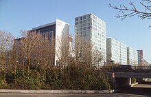
 Top to bottom, left to right: The Xscape and Theatre seen from Campbell Park; former railway works and new housing in Wolverton; Milton Keynes Central railway station; the Central Milton Keynes skyline; the central ecumenical Church of Christ the Cornerstone; and Bletchley's high street "Queensway". | |
 Milton Keynes Location within Buckinghamshire | |
| Area | 89 km2 (34 sq mi) [1] |
| Population | 229,941 (Urban Area, 2011 Census)[2] |
| • Density | 2,584/km2 (6,690/sq mi) |
| OS grid reference | SP841386 |
| • London | 50 mi (80 km)[a] SSE |
| Unitary authority |
|
| Ceremonial county |
|
| Region |
|
| Country | England |
| Sovereign state | United Kingdom |
| Post town | MILTON KEYNES |
| Postcode district | MK1–15, MK17, MK19 |
| Dialling code | 01908 |
| Police | Thames Valley |
| Fire | Buckinghamshire |
| Ambulance | South Central |
| UK Parliament | |
| Website | www |

Milton Keynes (/kiːnz/ (![]() listen) KEENZ) is the largest town[b] in Buckinghamshire, England, 50 miles (80 km) north-west of London. At the 2011 Census, the population of its urban area was almost 230,000. The River Great Ouse forms its northern boundary; a tributary, the River Ouzel, meanders through its linear parks and balancing lakes. Approximately 25% of the urban area is parkland or woodland and includes two Sites of Special Scientific Interest (SSSIs).
listen) KEENZ) is the largest town[b] in Buckinghamshire, England, 50 miles (80 km) north-west of London. At the 2011 Census, the population of its urban area was almost 230,000. The River Great Ouse forms its northern boundary; a tributary, the River Ouzel, meanders through its linear parks and balancing lakes. Approximately 25% of the urban area is parkland or woodland and includes two Sites of Special Scientific Interest (SSSIs).
In the 1960s, the UK Government decided that a further generation of new towns in the South East of England was needed to relieve housing congestion in London. This new town (in planning documents, 'new city'), Milton Keynes, was to be the biggest yet, with a target population of 250,000 and a 'designated area' of about 22,000 acres (9,000 ha). At designation, its area incorporated the existing towns of Bletchley, Fenny Stratford, Wolverton and Stony Stratford,[c] along with another fifteen villages and farmland in between. These settlements had an extensive historical record since the Norman conquest; detailed archaeological investigations prior to development revealed evidence of human occupation from the Neolithic age to modern times, including in particular the Milton Keynes Hoard of Bronze Age gold jewellery. The government established a Development Corporation (MKDC) to design and deliver this New City. The Corporation decided on a softer, more human-scaled landscape than in the earlier English new towns but with an emphatically modernist architecture. Recognising how traditional towns and cities had become choked in traffic, they established a 'relaxed' grid of distributor roads about 1 kilometre (0.62 mi) between edges, leaving the spaces between to develop more organically. An extensive network of shared paths for leisure cyclists and pedestrians criss-crosses through and between them. Again rejecting the residential tower blocks that had been so recently fashionable but unloved, they set a height limit of three storeys outside the planned centre.
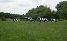
Facilities include a 1,400-seat theatre, a municipal art gallery, two multiplex cinemas, an ecumenical central church, a 400-seat concert hall, a teaching hospital, a 30,500-seat football stadium, an indoor ski-slope and a 65,000-capacity open-air concert venue. Seven railway stations serve the Milton Keynes urban area (one inter-city). The Open University is based here and there is a small campus of the University of Bedfordshire. Most major sports are represented at amateur level; Red Bull Racing (Formula One), MK Dons (association football), and Milton Keynes Lightning (ice hockey) are its professional teams. The Peace Pagoda overlooking Willen Lake was the first such to be built in Europe. Milton Keynes also is the site of the Concrete Cows, a well known work of art.
Milton Keynes has one of the more successful economies in the UK, ranked highly against a number of criteria. It has the UK's fifth highest number of business startups per capita (but equally of business failures). It is home to several major national and international companies. Despite this economic success and personal wealth for some, there are pockets of nationally significant poverty. The employment profile is composed of about 90% service industries and 9% manufacturing.
History[]
Birth of a 'new city'[]
It may startle some political economists to talk of commencing the building of new cities ... planned as cities from their first foundation, and not mere small towns and villages. ... A time will arrive when something of this sort must be done ... England cannot escape from the alternative of new city building.
In the 1960s, the UK government decided that a further generation of new towns in the South East of England was needed to relieve housing congestion in London.[8] Since the 1950s, overspill housing for several London boroughs had been constructed in Bletchley.[9][10][11] Further studies[8][12] in the 1960s identified north Buckinghamshire as a possible site for a large new town, a new city,[13][d] encompassing the existing towns of Bletchley, Stony Stratford, and Wolverton.[14] The New Town (informally and in planning documents, 'New City') was to be the biggest yet, with a target population of 250,000,[15][16] in a 'designated area' of 21,883 acres (8,855.7 ha).[1] The name 'Milton Keynes' was taken from that of an existing village on the site.[17]
On 23 January 1967, when the formal "new town designation order" was made,[1] the area to be developed was largely farmland and undeveloped villages. The site was deliberately located equidistant from London, Birmingham, Leicester, Oxford, and Cambridge,[18][19] with the intention that it would be self-sustaining and eventually become a major regional centre in its own right.[8] Planning control was taken from elected local authorities and delegated to the Milton Keynes Development Corporation (MKDC). Before construction began, every area was subject to detailed archaeological investigation: doing so has exposed a rich history of human settlement since Neolithic times and has provided a unique insight into the history of a large sample of the landscape of North Buckinghamshire.[20]
The Corporation's strongly modernist designs were regularly featured in the magazines Architectural Design and the Architects' Journal.[21][22][23] MKDC was determined to learn from the mistakes made in the earlier New Towns,[24][25] and revisit the Garden City ideals.[26][27] They set in place the characteristic grid roads that run between districts ('grid squares'), as well as a programme of intensive planting, balancing lakes and parkland.[28] Central Milton Keynes ("CMK") was not intended to be a traditional town centre but a central business and shopping district to supplement local centres embedded in most of the grid squares.[29] This non-hierarchical devolved city plan was a departure from the English New Towns tradition and envisaged a wide range of industry and diversity of housing styles and tenures.[30] The largest and almost the last of the British New Towns, Milton Keynes has 'stood the test of time far better than most, and has proved flexible and adaptable'.[31] The radical grid plan was inspired by the work of Melvin M. Webber,[32] described by the founding architect of Milton Keynes, Derek Walker, as the 'father of the city'.[33] Webber thought that telecommunications meant that the old idea of a city as a concentric cluster was out of date and that cities which enabled people to travel around them readily would be the thing of the future, achieving "community without propinquity" for residents.[34]
The government wound up MKDC in 1992, 25 years after the new town was founded, transferring control to the Commission for New Towns (CNT) and then finally to English Partnerships, with the planning function returning to local council control (since 1974 and the Local Government Act 1972, the Borough of Milton Keynes). From 2004–2011 a Government quango, the Milton Keynes Partnership, had development control powers to accelerate the growth of Milton Keynes.[35]
Along with many other towns and boroughs, Milton Keynes competed (unsuccessfully) for formal city status in the 2000, 2002 and 2012 competitions.[36]
Name[]
Labour Minister Dick Crossman …looked at [a] map and saw [the] name and said "Milton the poet, Keynes the economic one. 'Planning with economic sense and idealism, a very good name for it.'"
Jock Campbell, Baron Campbell of Eskan[37]
The name 'Milton Keynes' was a reuse of the name of one of the original historic villages in the designated area,[37] now more generally known as 'Milton Keynes Village' to distinguish it from the modern settlement. After the Norman conquest, the de Cahaignes family held the manor from 1166 to the late 13th century as well as others in the country (Ashton Keynes in Wiltshire, Somerford Keynes in Gloucestershire, and Horsted Keynes in West Sussex).[38] The village was originally known as Middeltone (11th century); then later as Middelton Kaynes or Caynes (13th century); Milton Keynes (15th century); and Milton alias Middelton Gaynes (17th century).[38]
Prior history[]

The area that was to become Milton Keynes encompassed a landscape that has a rich historic legacy. The area to be developed was largely farmland and undeveloped villages, but with evidence of permanent settlement dating back to the Bronze Age. Before construction began, every area was subject to detailed archaeological investigation: this work has provided an unprecedented[e] insight into the history of a very large sample of the landscape of south-central England. There is evidence of Stone Age,[39] late Bronze Age/early Iron Age,[40] Romano-British,[41][42] Anglo-Saxon,[43] Anglo-Norman,[44] Medieval,[45][43] and late Industrial Revolution settlements such as the railway towns of Wolverton (with its railway works) and Bletchley (at the junction of the London and North Western Railway with the Oxford–Cambridge Varsity Line).[46][47] The most notable archaeological artefact was the Milton Keynes Hoard, which the British Museum described as 'one of the biggest concentrations of Bronze Age gold known from Britain and seems to flaunt wealth.'[48]
Bletchley Park, the site of World War II Allied code-breaking and Colossus, the world's first programmable electronic digital computer,[49] is a major component of MK's modern history. It is now a flourishing heritage attraction, receiving hundreds of thousands of visitors annually.[50]
When the boundary of Milton Keynes was defined in 1967, some 40,000 people lived in three towns and fifteen villages or hamlets in the "designated area".[51][52]
Urban design[]
The radical plan, form and scale of Milton Keynes attracted international attention.[25] Early phases of development include work by celebrated architects, including Sir Richard MacCormac,[53] Norman Foster,[54] Henning Larsen,[55] Ralph Erskine,[56] John Winter,[57] and Martin Richardson.[31] Led by Lord Campbell of Eskan (Chairman) and Fred Roche (General Manager), the Corporation attracted talented young architects,[58] led by the respected designer,[58][59] Derek Walker. In the modernist Miesian tradition is the Shopping Building designed by Stuart Mosscrop and Christopher Woodward, a grade II listed building, which the Twentieth Century Society inter alia regards as the 'most distinguished' twentieth century retail building in Britain.[60][61] The Development Corporation also led an ambitious Public art programme.[62]
The urban design has not been universally praised. In 1980, the then president of the Royal Town Planning Institute, Francis Tibbalds, described Central Milton Keynes as "bland, rigid, sterile, and totally boring."[63] Michael Edwards, a member of the original consultancy team,[f] believes that there were weaknesses in their proposal and that the Development Corporation implemented it badly.[64]
Grid roads and grid squares[]
The geography of Milton Keynes – the railway line, Watling Street, Grand Union Canal, M1 motorway – sets up a very strong north-south axis. If you've got to build a city between (them), it is very natural to take a pen and draw the rungs of a ladder. Ten miles by six is the size of this city – 22,000 acres. Do you lay it out like an American city, rigid orthogonal from side to side? Being more sensitive in 1966-7, the designers decided that the grid concept should apply but should be a lazy grid following the flow of land, its valleys, its ebbs and flows. That would be nicer to look at, more economical and efficient to build, and would sit more beautifully as a landscape intervention.
David Lock[65]
The Milton Keynes Development Corporation planned the major road layout according to street hierarchy principles, using a grid pattern of approximately 1 km (0.62 mi) intervals, rather than on the more conventional radial pattern found in older settlements.[66] Major distributor roads run between communities, rather than through them: these distributor roads are known locally as grid roads and the spaces between them – the districts – are known as grid squares.[67] This spacing was chosen so that people would always be within six minutes' walking distance of a grid-road bus-stop.[29] Consequently, each grid square is a semi-autonomous community, making a unique collective of 100 clearly identifiable neighbourhoods within the overall urban environment.[68][g] The grid squares have a variety of development styles, ranging from conventional urban development and industrial parks to original rural and modern urban and suburban developments. Most grid squares have a local centre, intended as a retail hub, and many have community facilities as well. Each of the original villages is the heart of its own grid-square. Originally intended under the master plan to sit alongside the grid roads,[70] these local centres were mostly in fact built embedded in the communities.[71][64]
Although the 1970 master plan assumed cross-road junctions,[70] roundabout junctions were built at intersections because this type of junction is more efficient at dealing with small to medium volumes. Some major roads are dual carriageway, the others are single carriageway. Along one side of each single carriageway grid road, there is usually a (grassed) reservation to permit dualling or additional transport infrastructure at a later date.[h] As of 2018, this has been limited to some dualling. The edges of each grid square are landscaped and densely planted – some additionally have noise attenuation mounds – to minimise traffic noise from the grid road impacting the adjacent grid square. Traffic movements are fast, with relatively little congestion since there are alternative routes to any particular destination other than during peak periods. The national speed limit applies on the grid roads, although lower speed limits have been introduced on some stretches to reduce accident rates. Pedestrians rarely need to cross grid roads at grade, as underpasses and bridges were specified at frequent places along each stretch of all of the grid roads.[70] In contrast, the later districts planned by English Partnerships have departed from this model, without a road hierarchy but with conventional junctions with traffic lights and at grade pedestrian crossings.[73][74][i]
Redways[]

There is a separate network (approximately 170 miles (270 km) total length) of cycle and pedestrian routes – the redways – that runs through the grid-squares and often runs alongside the grid-road network.[75] This was designed to segregate slow moving cycle and pedestrian traffic from fast moving motor traffic.[69] In practice, it is mainly used for leisure cycling rather than commuting, perhaps because the cycle routes are shared with pedestrians, cross the grid-roads via bridge or underpass rather than at grade, and because some take meandering scenic routes rather than straight lines. It is so called because it is generally surfaced with red tarmac.[76] The national Sustrans national cycle network routes 6 and 51 take advantage of this system.[77][78]
Height[]
The original design guidance declared that commercial building heights in the centre should not exceed six storeys, with a limit of three storeys for houses (elsewhere),[21] paraphrased locally as "no building taller than the tallest tree".[79] In contrast, the Milton Keynes Partnership, in its expansion plans for Milton Keynes, believed that Central Milton Keynes (and elsewhere) needed "landmark buildings" and subsequently lifted the height restriction for the area.[79] As a result, high rise buildings have been built in the central business district.[j] More recent local plans have protected the existing boulevard framework and set higher standards for architectural excellence.[83][k]
Linear parks[]

The flood plains of the Great Ouse and of its tributaries (the Ouzel and some brooks) have been protected as linear parks that run right through Milton Keynes; these were identified as important landscape and flood-management assets from the outset.[85] At 4,100 acres (1,650 ha) – ten times larger than London's Hyde Park and a third larger than Richmond Park[86] – the landscape architects realised that the Royal Parks model would not be appropriate or affordable and drew on their National Park experience.[86] As Bendixson and Platt (1992) write: "They divided the Ouzel Valley into 'strings, beads and settings'. The 'strings' are well-maintained routes, be they for walking, bicycling or riding; the 'beads' are sports centres, lakeside cafes and other activity areas; the 'settings' are self-managed land-uses such as woods, riding paddocks, a golf course and a farm".[86]
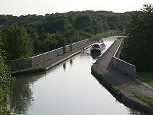
The Grand Union Canal is another green route (and demonstrates the level geography of the area – there is just one minor lock in its entire 10-mile (16 km) meandering route through from the southern boundary near Fenny Stratford to the "Iron Trunk" aqueduct over the Ouse at Wolverton at its northern boundary). The initial park system was planned by Peter Youngman (Chief Landscape Architect),[87] who also developed landscape precepts for all development areas: groups of grid squares were to be planted with different selections of trees and shrubs to give them distinct identities. The detailed planning and landscape design of parks and of the grid roads was evolved under the leadership of Neil Higson,[88] who from 1977 took over from Youngman.[89]
In a national comparison of urban areas by open space available to residents, Milton Keynes ranked highest in the UK.[90]
Forest city concept[]
The Development Corporation's original design concept aimed for a "forest city" and its foresters planted millions of trees from its own nursery in Newlands in the following years.[33] Parks, lakes and green spaces cover about 25% of Milton Keynes;[91][92] as of 2018, there are 22 million trees and shrubs in public open spaces.[93][92] When the Development Corporation was being wound up, it transferred the major parks, lakes, river-banks and grid-road margins to the Parks Trust,[94] a charity which is independent of the municipal authority.[91] MKDC endowed the Parks Trust with a portfolio of commercial properties, the income from which pays for the upkeep of the green spaces.[91] As of 2018, approximately 25% of the urban area is parkland or woodland.[95] It includes two Sites of Special Scientific Interest, Howe Park Wood and Oxley Mead.
Centre[]
As a key element of the planners' vision,[96] Milton Keynes has a purpose built centre, with a very large "covered high street" shopping centre,[97] a theatre,[98][99] municipal art gallery,[98][99] a multiplex cinema,[100] hotels,[101] central business district,[96] an ecumenical church,[102] Borough Council offices[103] and central railway station.[104]
Original towns and villages[]


Milton Keynes consists of many pre-existing towns and villages that anchored the urban design,[14] as well as new infill developments. The modern-day urban area outside the four main towns (Bletchley, Newport Pagnell, Stony Stratford, Wolverton) was largely rural farmland but included many picturesque North Buckinghamshire villages and hamlets: Bradwell village and its Abbey, Broughton, Caldecotte, Fenny Stratford, Great Linford, Loughton, Milton Keynes Village, New Bradwell, Shenley Brook End, Shenley Church End, Simpson, Stantonbury, Tattenhoe, Tongwell, Walton, Water Eaton, Wavendon, Willen, Great and Little Woolstone, Woughton on the Green.[14] These historical settlements were made the focal points of their respective grid square. Every other district has an historical antecedent, if only in original farms or even field names.[105]
Bletchley was first recorded in the 12th century as Blechelai.[46] Its station was an important junction (the London and North Western Railway with the Oxford-Cambridge Varsity Line), leading to the substantial urban growth in the town in the Victorian period.[46] It expanded to absorb the village of Water Eaton and town of Fenny Stratford.[46]
Bradwell is a traditional rural village with earthworks of a Norman motte and bailey and parish church.[106] There is a YHA hostel beside the church.[107]
Bradwell Abbey, a former Benedictine Priory and Scheduled Ancient Monument,[108] was of major economic importance in this area of North Buckinghamshire before its dissolution in 1524.[109] Nowadays there is only a small medieval chapel and a manor house occupying the site.[110][111]
New Bradwell, to the north of Bradwell and east of Wolverton, was built specifically for railway workers.[106] The level bed of the old Wolverton to Newport Pagnell Line near here has been converted to a redway, making it a favoured route for cycling.[112] A working windmill is sited on a hill outside the village.[113]
Great Linford appears in the Domesday Book as Linforde, and features a church dedicated to Saint Andrew, dating from 1215.[114] Today, the outer buildings of the 17th century manor house form an arts centre.[115]
Milton Keynes (Village) is the original village to which the New Town owes its name.[17] The original village is still evident, with a pleasant thatched pub, village hall, church and traditional housing. The area around the village has reverted to its 11th century name of Middleton (Middeltone).[116] The oldest surviving domestic building in the area (c. 1300 CE), "perhaps the manor house", is here.[117]
Stony Stratford began as a settlement on Watling Street during the Roman occupation, beside the ford over the Great Ouse.[118] There has been a market here since 1194 (by charter of King Richard I).[119] The former Rose and Crown Inn on the High Street is reputedly the last place the Princes in the Tower were seen alive.[118]
The manor house of Walton village, Walton Hall, is the headquarters of the Open University and the tiny parish church (deconsecrated) is in its grounds.[120]
The small parish church (1680) at Willen was designed by the architect and physicist Robert Hooke.[121][122] Nearby, there is a Buddhist Temple and a Peace Pagoda, which was built in 1980 and was the first built by the Nipponzan-Myōhōji Buddhist Order in the western world.[123]
The original Wolverton was a medieval settlement just north and west of today's town.[47] The ridge and furrow pattern of agriculture can still be seen in the nearby fields.[124] The 12th century (rebuilt in 1819) 'Church of the Holy Trinity' still stands next to the Norman motte and bailey site.[47] Modern Wolverton was a 19th-century New Town built to house the workers at the Wolverton railway works, which built engines and carriages for the London and North Western Railway.[47]
Among the smaller villages and hamlets are three – Broughton, Loughton and Woughton on the Green – that are of note in that their names each use a different pronunciation[l] of the ough letter sequence in English.[125]
Education[]
Schools[]
In early planning, education provision was carefully integrated into the development plans with the intention that school journeys would, as far as possible, be made by walking and cycling. Each residential grid square was provided with a primary school (ages 5 to 8) for c.240 children, and for each two squares there was a middle school (ages 8 to 12) for c.480 children. For each 8 squares there was a large secondary education campus, to contain between two and four schools for a total of 3000 – 4500 children. All the schools on a campus were served by a central Resource Area. In addition, the campus included a Leisure Centre with indoor and outdoor sports facilities and a swimming pool, plus a theatre. These facilities were available to the public outside school hours, thus maximising use of the investment.[126] Changes in Central Government policy from the 1980s onwards subsequently led to much of this system being abandoned. Some schools have since been merged and sites sold for development, many converted to academies, and the leisure centres outsourced to commercial providers.
As in most parts of the UK, the state secondary schools in Milton Keynes are comprehensives,[127] although schools in the rest of Buckinghamshire still use the tripartite system.[128] Private schools are also available.[129]
Universities and colleges[]
The Open University's headquarters are in the Walton Hall district; though because this is a distance learning institution, the only students resident on campus are approximately 200 full-time postgraduates. Cranfield University, an all-postgraduate institution, is in nearby Cranfield, Bedfordshire. Milton Keynes College provides further education up to foundation degree level. University Campus Milton Keynes, a campus of the University of Bedfordshire, provides some tertiary education facilities locally. As of 2020, Milton Keynes is the UK's largest population centre without its own conventional university, a shortfall that the Council aims to rectify.[130] In January 2019, the Council and its partner, Cranfield University, invited proposals to design a campus near the Central station for a new university, code-named MK:U.[131] Through Milton Keynes University Hospital, the city also has links with the University of Buckingham's medical school.
City development archive and library[]
Milton Keynes City Discovery Centre at Bradwell Abbey holds an extensive archive about the planning and development of Milton Keynes and has an associated research library.[132] The Centre also offers an education programme (with a focus on urban geography and local history) to schools, universities and professionals.[132]
Culture, media and sport[]
Music[]

The open-air National Bowl is a 65,000-capacity venue for large-scale events.[133]
In Wavendon, the Stables – founded by the jazz musicians Cleo Laine and John Dankworth – provides a venue for jazz, blues, folk, rock, classical, pop and world music.[134] It presents around 400 concerts and over 200 educational events each year and also hosts the National Youth Music Camps summer camp for young musicians.[135] In 2010, the Stables founded the biennial IF Milton Keynes International Festival, producing events in unconventional spaces and places across Milton Keynes.[136]
Milton Keynes City Orchestra is a professional freelance orchestra based at Woughton Campus.[137]
Arts, cinema, theatre and museums[]
The municipal public art gallery, MK Gallery, presents free exhibitions of international contemporary art.[138] The gallery was extended and remodelled in 2018/19 and includes an art-house cinema.[139][140][141] There are also two multiplex cinemas; one in CMK and one in Denbigh.
In 1999, the adjacent 1,400-seat Milton Keynes Theatre opened.[142] The theatre has an unusual feature: the ceiling can be lowered closing off the third tier (gallery) to create a more intimate space for smaller-scale productions.[142][143] There is a further professional performance space in Stantonbury.[144]
There are three museums: the Bletchley Park complex, which houses the museum of wartime cryptography;[145] the National Museum of Computing (adjacent to Bletchley Park, with a separate entrance), which includes a working replica of the Colossus computer;[146] and the Milton Keynes Museum, which includes the Stacey Hill Collection of rural life that existed before the foundation of MK, the British Telecom collection, and the original Concrete Cows.[147] Other numerous public sculptures in Milton Keynes include work by Elisabeth Frink, Philip Jackson, Nicolas Moreton and Ronald Rae.[148]
Milton Keynes Arts Centre offers a year-round exhibition programme, family workshops and courses. The Centre is based in some of Linford Manor's historical exterior buildings, barns, almshouses and pavilions.[115] The Westbury Arts Centre in Shenley Wood is based in a 16th-century grade II listed farmhouse building. Westbury Arts has been providing spaces and studios for professional artists since 1994.[149]
Communications and media[]
For television, the area is allocated to BBC East and Anglia ITV.[150] For radio, Milton Keynes is served by Heart East (a regional commercial station based locally) and two community radio stations (MKFM and Secklow 105.5).[151][152] BBC Three Counties Radio is the local BBC Radio station.[153] CRMK (Cable Radio Milton Keynes) is a voluntary station broadcasting on the Internet.[154]
As of September 2021, Milton Keynes has one local newspaper, the Milton Keynes Citizen,[155][m] which has a significant online presence.
Sport[]
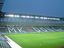
Milton Keynes has professional teams in football (Milton Keynes Dons F.C. at Stadium MK), in ice hockey (Milton Keynes Lightning at Planet Ice Milton Keynes), and in Formula One (Red Bull Racing).[157]
The Xscape indoor ski slope and the iFLY indoor sky diving facility are important attractions in CMK;[157] the National Badminton Centre in Loughton is home to the national badminton squad and headquarters of Badminton England.[157][158]
Many other sports are represented at amateur level.
Near the central station, in a space beside the former Milton Keynes central bus station, there is a purpose-built street skateboarding plaza named the Buszy.[159]
Willen Lake hosts watersports on the south basin.[160][161]
Government[]
Local government[]
The responsible local government is Milton Keynes Council, which controls the Borough of Milton Keynes, a Unitary Authority (and, in law, a non-metropolitan county) since May 1996.[162] Until then, it was controlled by Buckinghamshire County Council. Historically, most of the area that became Milton Keynes was known as the "Three Hundreds of Newport".[45]
Modern parishes, community councils and districts[]
The Borough of Milton Keynes is fully parished.[163] The urban parishes (and the districts they contain) are listed at Borough of Milton Keynes (urban area).
International co-operation[]
Although Milton Keynes has no formalised twinning agreements, it has partnered and co-operated with various cities over the years. The most contact has been with Almere, Netherlands, especially on energy management and urban planning.[164] Due to the twinning of the Borough of Milton Keynes and the equivalent administrative region of Bernkastel-Wittlich, the Council has worked with Bernkastel-Kues, Germany, for example on art projects.[165] In 2017 they partnered with the Chinese fellow smart city of Yinchuan.[166]
Infrastructure[]
Hospitals[]
Milton Keynes University Hospital, in the Eaglestone district, is an NHS general hospital with an Accident and Emergency unit.[167] It is associated for medical teaching purposes with the University of Buckingham medical school.[168] There are two small private hospitals: BMI Healthcare's Saxon Clinic and Ramsay Health Care's Blakelands Hospital.[169][170]
Prison[]
There is a Category A male prison, HMP Woodhill, on the western boundary.[171] A section of the prison is a Young Offenders Institution.[172]
Transport[]
The Grand Union Canal, the West Coast Main Line, the A5 road and the M1 motorway provide the major axes that influenced the urban designers.[85]
The urban area is served by seven railway stations.[173] Wolverton, Milton Keynes Central and Bletchley stations are on the West Coast Main Line and are served by local commuter services between London and Birmingham or Crewe.[174] Milton Keynes Central is also served by inter-city services between London and Scotland, Wales, the North West and the West Midlands: express services to London take 35 minutes.[174] Bletchley, Fenny Stratford, Bow Brickhill, Woburn Sands and Aspley Guise railway stations are on the Marston Vale line to Bedford.[174]
The M1 motorway runs along the east flank of MK and serves it from junctions 11a, 13, 14 and 15. The A5 road runs right through as a grade separated dual carriageway. Other main roads are the A509 to Wellingborough and Kettering, and the A421 and A422, both running west towards Buckingham and east towards Bedford. Additionally, the A4146 runs from (near) junction 14 of the M1 to Leighton Buzzard.[175] Proximity to the M1 has led to construction of a number of distribution centres, including Magna Park at the south-eastern flank of Milton Keynes, near Wavendon.[176]
Many long-distance coaches stop at the Milton Keynes coachway,[177] (beside M1 Junction 14), about 3.3 miles (5.3 km) from the centre and 4.3 mi (7 km) from Milton Keynes Central railway station.[178] There is also a park and ride car park on the site. Regional coaches stop at Milton Keynes Central.[179]
Milton Keynes is served by (and, via its Redway network, provides part of) routes 6 and 51 on the National Cycle Network.[77][78]
The nearest international airport is London Luton and is easily reached by coach.[180] Cranfield Airport, an airfield, is 8 miles (13 km) away.[181]
Demographics[]

At the 2011 census, the population of the Milton Keynes urban area, including the adjacent Newport Pagnell and Woburn Sands, was 229,941.[2] The population of the Borough in total was 248,800,[182] compared with a population of around 53,000 for the same area in 1961.[183] In 2016, the Office for National Statistics estimated that it will reach 300,000 by 2025.[52] As of June 2019, the population is estimated to have reached 245,404.[184]
The average age of the population is lower than is typical for the UK's 63 primary urban areas: 25.3% of the Borough population were aged under 18 (5th place) and 13.4% were aged 65+ (57th out of 63).[185][2] The mean age is 35.7 and the median age is 35.[2] 18.5% of residents were born outside the UK (11th).[185] At the 2011 census, the ethnic profile was 78.9% white, 3.4% mixed, 9.7% Asian/Asian British, 7.3% Black/African/Caribbean/Black British, and 0.7% other.[2] The religious profile was that 62.0% of people were reported having a religion and 31.4% having none; the remainder declined to say: 52% are Christian, 5.1% Muslim, 3.0% Hindu; other religions each had less than 1% of the population.[2]
Economy, finances and business[]
Milton Keynes is one of the most successful economies in the UK, ranked third (by gross value added per worker) for its contribution to the national economy.[185]
Major businesses[]
Milton Keynes has consistently benefited from above-average economic growth, ranked as one of the UK's top five cities.[186] It is ranked fifth in the UK for business startups (per 10,000 people).[185]
Milton Keynes is home to several national and international companies, notably Argos,[187] Domino's Pizza,[188] Marshall Amplification,[189] Mercedes-Benz,[190] Suzuki,[191] Volkswagen Group,[192] Red Bull Racing,[193] Network Rail,[194] and Yamaha Music Europe.[195]
Santander UK and the Open University are major employers locally.[196][197]
Small and medium enterprise[]
In 2013,[n] 99.4% of enterprises being SMEs, just 0.6% of businesses locally employ more than 250 people (but more than one third of employees),[199] whereas 81.5% employ fewer than 10 people.[199] The 'professional, scientific and technical sector' contributes the largest number of business units, 16.7%.[199] The retail sector is the largest contributor of employment.[199][2] Milton Keynes has one of the highest number of business start-ups in England, but also of failures.[185] Although education, health and public administration are important contributors to employment, the contribution is significantly less than the averages for England or the South East.[199]
Employment[]
75% of the population is economically active, including 8.3% (of the population) who are self-employed.[2] 90% work in service industries of various sorts (of which wholesale and retail is the largest sector) and 9% in manufacturing.[2]
Social inequality[]
In 2015, the Borough of Milton Keynes had nine 'lower super output areas'[o] that are in the 10% most deprived in England, but also had twelve 'lower super output areas' in the 10% least deprived in England.[201] This contrast between areas of affluence and areas of deprivation in spite of a thriving local economy, inspired local charity The Community Foundation (in its 2016 'Vital Signs' report) to describe the position as a 'Tale of Two Cities'.[202]
In 2018, the number of homeless young people sleeping rough in tents around CMK attracted national headlines as it became the apex of a national problem of poverty, inadequate mental health care and unaffordable housing.[203][204] On a visit to refurbishment and extension work on the YMCA building, Housing Minister Heather Wheeler declared that 'Nobody in this day and age should be sleeping on the street'.[205]
Geography[]
Location and nearest settlements[]
Milton Keynes is in south central England, at the northern end of the South East England region,[206] about 50 miles (80 km) north-west of London.[3][4][5]
The nearest larger[p] towns are Northampton, Bedford, Luton and Aylesbury.[207] The nearest larger[q] cities are Coventry, Leicester, Cambridge, London and Oxford.[208]
Destinations from Milton Keynes | ||||||||||
|---|---|---|---|---|---|---|---|---|---|---|
| ||||||||||
Geology[]
Its surface geology is primarily gently rolling Oxford clay or, more formally:
... a portion of more or less dissected boulder clay plateau, with streams falling fairly steeply to the [Great] Ouse and Ouzel flood plains, across slopes cut chiefly in Oxford clay. Middle Jurassic rocks, in particular the Blisworth limestone and cornbrash, form strong features in the lands bordering the Ouse valley in the north.[209]
Its highest points are in the centre (110 m (360 ft)) and at Woodhill on the western boundary (120 m (390 ft)).[210][211] The lowest point of the urban area is in Newport Pagnell, where the Ouzel joins the Great Ouse.(50 m (160 ft)).[212]
Parks and environmental infrastructure[]
Because of the (poorly drained) clay soils and the urban hard surfaces, the Development Corporation identified water runoff into the Ouzel and its tributaries as a significant risk to be managed and so put in place two large balancing lakes (Caldecotte and Willen) and a number of smaller detention ponds.[213] These provide an important leisure amenity for most of the year.[214] Building in the floodplains of the Ouse and Ouzel was precluded too, thus providing long-distance linear parks that are within easy reach of most residents.
The north basin of Willen Lake is a bird sanctuary.[160]
The two Sites of Special Scientific Interest, Howe Park Wood and Oxley Mead, are the most significant of a number of important wildlife sites in and around MK.[215]
Just outside the Milton Keynes urban area lies Little Linford Wood, a conservation site and nature reserve managed by the Berkshire, Buckinghamshire and Oxfordshire Wildlife Trust. It is considered to be one of the best habitats for dormice.[216]
Climate[]
Milton Keynes experiences an oceanic climate (Köppen climate classification Cfb) as is typical of almost all of the United Kingdom.
The nearest Met Office weather station is in Woburn,[217] located in a rural area just outside the south eastern fringe of Milton Keynes. Recorded temperature extremes range from 34.6 °C (94.3 °F) during July 2006,[218] to as low as −20.6 °C (−5.1 °F) on 25 February 1947; this is the lowest temperature ever reported in England in February.[219] In 2010, the temperature fell to −16.3 °C (2.7 °F)[220]
| Climate data for Woburn 1981–2010 (Weather station 3 mi (5 km) to the SE of Central Milton Keynes) | |||||||||||||
|---|---|---|---|---|---|---|---|---|---|---|---|---|---|
| Month | Jan | Feb | Mar | Apr | May | Jun | Jul | Aug | Sep | Oct | Nov | Dec | Year |
| Average high °C (°F) | 7.0 (44.6) |
7.4 (45.3) |
10.3 (50.5) |
13.1 (55.6) |
16.6 (61.9) |
19.6 (67.3) |
22.1 (71.8) |
21.9 (71.4) |
18.7 (65.7) |
14.4 (57.9) |
10.0 (50.0) |
7.2 (45.0) |
14.1 (57.4) |
| Average low °C (°F) | 1.3 (34.3) |
0.9 (33.6) |
2.7 (36.9) |
3.8 (38.8) |
6.5 (43.7) |
9.4 (48.9) |
11.7 (53.1) |
11.6 (52.9) |
9.6 (49.3) |
7.0 (44.6) |
3.8 (38.8) |
1.5 (34.7) |
5.8 (42.4) |
| Average precipitation mm (inches) | 54.2 (2.13) |
41.7 (1.64) |
45.3 (1.78) |
52.1 (2.05) |
54.3 (2.14) |
53.2 (2.09) |
53.1 (2.09) |
55.4 (2.18) |
57.5 (2.26) |
70.3 (2.77) |
63.0 (2.48) |
57.3 (2.26) |
657.4 (25.88) |
| Mean monthly sunshine hours | 52.0 | 69.4 | 105.5 | 147.4 | 183.4 | 179.9 | 197.1 | 189.0 | 137.0 | 105.6 | 61.7 | 43.5 | 1,471.6 |
| Source: Met Office[221] | |||||||||||||
Notable people[]
Sports[]
- Charles Ademeno, former professional footballer[222]
- Dele Alli, professional footballer[223]
- Andrew Baggaley, English table tennis champion[224]
- Brothers George and Sam Baldock, professional footballers.[225][226][227]
- Ben Chilwell, professional footballer[228]
- Chris Clarke, English sprinter[229]
- Lee Hasdell, professional Mixed martial artist and Kickboxer[230]
- James Hildreth, professional cricketer[231]
- Liam Kelly, professional footballer[232]
- Craig Pickering, English sprinter[233]
- Ian Poulter, PGA & European Tour golf professional. Member of the 2010 and 2012 European Ryder Cup Teams[234]
- Mark Randall, professional footballer[235]
- Antonee Robinson, professional footballer[236]
- Greg Rutherford, long jump gold medallist for Team GB at the 2012 Olympic Games[237]
- Ed Slater, professional rugby union player[238]
- Fallon Sherrock, professional darts player.[239]
- Sam Tomkins, professional rugby league player[240]
- Dan Wheldon (1978–2011), Indy car driver[241]
- Leah Williamson, professional footballer[242]
Business[]
- Jim Marshall (1923–2012), founder and CEO of Marshall Amplification was living in and ran his business from Milton Keynes when he died[243]
- Pete Winkelman, Chairman of Milton Keynes Dons Football Club, owner of Linford Manor recording studios, long-term resident[244]
Academic[]
- Christopher B-Lynch, (visiting) Professor of Obstetrics and Gynaecology at Cranfield University, responsible for inventing the eponymously named B-Lynch suture[245][246]
- Alan P. F. Sell (1935–2016), academic and theologian lived in the town in his later years and died there[247][248]
- Alan Turing (1912–1954), played a significant role in the creation of the modern computer. He lodged at the Crown Inn, Shenley Brook End, while working at Bletchley Park[249]
Stage, screen and media[]
- Errol Barnett, an anchor and correspondent for CNN[250]
- Emily Bergl, an actress known for her roles in Desperate Housewives and Shameless[251]
- Richard Macer, documentary maker[252]
- Clare Nasir, the meteorologist, TV and radio personality, was born in Milton Keynes in 1970[253]
- Kevin Whately, professional actor[254]
Literature[]
- Sarah Pinborough, English horror writer[255]
- Jack Trevor Story, novelist, was a long-term resident of Milton Keynes[256]
Politics[]
- Nat Wei, Baron Wei, member of the House of Lords[257]
Music[]
Individual[]
- Adam Ficek, drummer of London band Babyshambles[258]
- Gordon Moakes, the bassist for the London-based rock band Bloc Party[259]
- Geordie Walker, guitarist with the band 'Killing Joke'[260]
Bands[]
- Capdown, a ska punk band, came from and formed in Milton Keynes in 1997[261]
- Fellsilent, a metal band, come from and formed in Milton Keynes in 2003[262][263]
- Tesseract, a djent band, formed as a full live act in Milton Keynes in 2007.[264] Tesseract's guitarist, songwriter and producer Acle Kahney is also a former member of Fellsilent.[263]
- Hacktivist, a Grime and djent band[265]
- RavenEye, the rock band, formed in Milton Keynes in 2014[266]
Freedom of the Borough[]
Notes[]
- ^ From Milton Keynes Bowl to Marble Arch via Watling Street is 45 miles (72 km).[3] By rail from Milton Keynes Central to Euston is 49 miles 65 chains (49.81 mi; 80.17 km).[4] From Central Milton Keynes to Charing Cross via the M1 motorway is 55 miles (89 km).[5]
- ^ Although Milton Keynes was specified to be a city in scale and the term "city" is used locally (inter alia to avoid confusion with its constituent towns), formally this title cannot be used. This is because conferment of city status in the United Kingdom is a royal prerogative. It is considerably larger than the nearby cities of Oxford, Cambridge and St Albans.
- ^ The adjacent towns of Newport Pagnell and Woburn Sands were not included in the original 1967 designated area of the New Town but have become part of the Milton Keynes urban area since then.
- ^ The Plan for Milton Keynes begins (in the Foreword by Lord ("Jock") Campbell of Eskan): "This plan for building the new city of Milton Keynes ... "
- ^ in scale
- ^ and erstwhile lecturer in urban planning at University College London
- ^ Bendixson & Platt report the Corporation as concerned at this outcome, which was an unanticipated emergent behaviour. In later developments, it aimed for increased permeability through the grid.[69]
- ^ An additional ten-metre wide strip was originally specified to satisfy Buckinghamshire County Council's belief in a future fixed-track public transport system. In 1977 MKDC decided to cease to specify it.[72]
- ^ The 'western expansion area' is what became Fairfields and Whitehouse. The 'eastern expansion area' is Broughton including Brooklands. 'The Hub' is a development of residential tower, hotels and restaurants in CMK.
- ^ Large-scale buildings include Jurys Inn (10 storeys)[80] The Pinnacle:MK on Midsummer Boulevard (9 storeys)[81] and the Vizion development on Avebury Boulevard (12 storeys).[82]
- ^ The more recent Network Rail National Centre has been built at the western limit of Silbury Boulevard near the Central station; this building complex occupies a large land area but only rises to the equivalent of six storeys.[84]
- ^ /ˈbrɔːtən/, BRAW-tən; /ˈlaʊtən/, rhymes with now; and /ˈwʊftən/ WUUF-tən respectively
- ^ A competing paper, MK News, closed in October 2016.[156]
- ^ An updated report for 2016 is available but does not give this data.[198]
- ^ A 'lower super output area' is a small geographic area defined by the Office of National Statistics to contain 1,000 to 1,500 residents and thus to permit consistent national comparisons.[200]
- ^ population over 50,000.
- ^ population over 100,000. St Albans, a cathedral city of 57,000, is closer.
References[]
- ^ a b c "North Buckinghamshire (Milton Keynes) New Town (Designation) Order". The London Gazette (44233): 827. 24 January 1967. Retrieved 14 January 2014.
- ^ a b c d e f g h i UK Census (2011). "Local Area Report – Milton Keynes built-up area (E34005056)". Nomis. Office for National Statistics. Retrieved 3 August 2020.
- ^ a b According to a nearby historic milestone.
- ^ a b "Engineer's Line References". RailwayCodes.org. 28 July 2018. Retrieved 15 February 2019.
- ^ a b "Central Milton Keynes to Charing Cross". Google Maps. Retrieved 15 February 2019.
- ^ Maslen, T. J. (1843). Suggestions for the improvement of Our Towns and Houses. London: Smith, Elder. (Quoted in Walter L Crease, The search for Environment, Yale University Press, New Haven and London, 1966, p319).
- ^ Bendixson & Platt 1992, p. 265.
- ^ a b c South East Study 1961–1981 (Report). London: HMSO. 1964.
A big change in the economic balance within the south east is needed to modify the dominance of London and to get a more even distribution of growth
cited in The Plan for Milton Keynes (Llewellyn-Davies et al (1970), page 3 - ^ "Bletchley Pioneers, Planning, & Progress". Clutch.open.ac.uk. Retrieved 23 November 2012.
- ^ "Early days of overspill". Clutch.open.ac.uk. Retrieved 23 November 2012.
- ^ "Need for more planned towns in the South-East". The Times. 2 December 1964.
- ^ "Urgent action to meet London housing needs". The Times. 4 February 1965.
- ^ Llewellyn-Davies et al. 1970, p. xi.
- ^ a b c Llewellyn-Davies et al. 1970, p. 8.
- ^ "Area of New Town Increased by 6000 acres". The Times. 14 January 1966.
- ^ Llewellyn-Davies et al. 1970, p. 4.
- ^ a b Llewellyn-Davies et al. 1970, p. 3.
- ^ Llewellyn-Davies; Forestier-Walker; Bor (December 1968). Milton Keynes: Interim Report to Milton Keynes Development Corporation. Milton Keynes Development Corporation.
- ^ Llewellyn-Davies et al. 1970, p. xii.
- ^ Croft, R. A.; Mynard, Dennis C.; Gelling, Margaret (1993). The Changing Landscape of Milton Keynes. Buckinghamshire Archaeological Society Monograph Series. Aylesbury: Buckinghamshire Archaeological Society. ISBN 9780949003126.
The creation of Milton Keynes provided an opportunity to study an extensive rural landscape before it was changed irreversibly. This book brings together the results of 20 years of excavation, fieldwork and documentary studies carried out by the Milton Keynes Development Corporation.
- ^ a b Bendixson & Platt 1992, p. 107.
- ^ "Architectural Design 6, 1973. Special issue: Milton Keynes". Architectural Design. 1973. Retrieved 26 February 2019. Staff of MKDC on the cover of Architectural Design
- ^ "AJ archive: Milton Keynes planning study (1969)". The Architects' Journal. 1969. Retrieved 10 February 2019. reprint 23 January 2017
- ^ Bendixson & Platt 1992, pp. 1, 47.
- ^ a b Barkham, Patrick (3 May 2016). "The struggle for the soul of Milton Keynes". The Guardian. Retrieved 11 May 2016.
- ^ Clapson 2014, p. 3.
- ^ Bendixson & Platt 1992, p. xii.
- ^ Milton Keynes: A Living Landscape, Fred Roche Foundation, 2018
- ^ a b Llewellyn-Davies et al. 1970, p. 33.
- ^ Llewellyn-Davies et al. 1970, p. 14.
- ^ a b Bishop, Jeffrey (1981). Milton Keynes – the Best of Both Worlds? Public and professional views of a new city. University of Bristol School for Advanced Urban Studies. ISBN 9780862922245. OCLC 756979521.
- ^ Bendixson & Platt 1992, p. 46.
- ^ a b Walker The Architecture and Planning of Milton Keynes, Architectural Press, London 1981. Retrieved 13 February 2007
- ^ Webber, M (1963). "Order in Diversity: Community Without Propinquity". In Wingo, L (ed.). Cities and Spaces. Baltimore: Hopkins.
- ^ "MILTON KEYNES PARTNERSHIP COMMITTEE ROLE AND REMIT". Milton Keynes Council. 7 September 2005. Retrieved 18 February 2019.
- ^ "This is not a city: Milton Keynes". The Open University. Retrieved 17 February 2019.
- ^ a b Dave Persaud. "Father of the New City". Milton Keynes: Living Archive.
- ^ a b "Parishes : Milton Keynes". A History of the County of Buckingham. Victoria History of the Counties of England. 4. Constable & Co. Ltd. 1927. pp. 401–405.
- ^ "Archaeology in the Milton Keynes District: Stone Age". Milton Keynes Heritage Association. Archived from the original on 8 November 2006. Retrieved 3 January 2007.
- ^ "Archaeology in the Milton Keynes District: Bronze Age". Milton Keynes Heritage Association. Archived from the original on 8 November 2006. Retrieved 3 January 2007.
- ^ "Object 2234: "Gold stater ('Gallo-Belgic A' type) Roman, mid-2nd century BC Probably made in northern France or Belgium; found at Fenny Stratford near Milton Keynes, England"". British Museum. Retrieved 10 September 2009.
- ^ "Archaeology in the Milton Keynes District: archaeological sites and artefacts found at Bancroft and Blue Bridge, part of the old farmland of Stacey Hill Farm, now Milton Keynes Museum". Milton Keynes Heritage Association. Retrieved 3 January 2007.
- ^ a b Mynard, Dennis; Hunt, Julian (1994). Milton Keynes, a pictorial history. ISBN 978-0-85033-940-6.
- ^ Domesday Book, Buckinghamshire
- ^ a b "Newport Hundred: Introduction". A History of the County of Buckingham. Victoria History of the Counties of England. 4. 1927. p. 268–269.
- ^ a b c d "Parishes: Bletchley with Fenny Stratford and Water Eaton". A History of the County of Buckingham. Victoria History of the Counties of England. 4. Constable & Co. Ltd. 1927. pp. 274–283. Retrieved 17 August 2009.
- ^ a b c d "Parishes: Wolverton". A History of the County of Buckingham. Victoria History of the Counties of England. 4. Constable & Co. Ltd. 1927. p. 505–509. Retrieved 17 February 2019.
- ^ "The Milton Keynes hoard". British Museum/Google Cultural Institute. Retrieved 31 January 2018.
- ^ Copeland 2006, Introduction p. 2.
- ^ "Bletchley Park welcomes 2015's 200,000th visitor". Bletchley Park. 26 August 2015. Retrieved 25 January 2017.
- ^ Bendixson & Platt 1992, p. 273.
- ^ a b "Milton Keynes at 50: Success town has 'nothing to be ashamed of'". BBC. 1 January 2017. Retrieved 13 February 2019.
- ^ Melvin, Jeremy (12 August 2014). "Richard MacCormac (1938–2014)". Architectural Review.
- ^ Hatherley, Owen (2010). A guide to the new ruins of Great Britain (PDF). New York: Verso. p. 60. ISBN 978-1-84467-700-9.
- ^ "Building of the month: Heelands Housing, Milton Keynes". Twentieth Century Society. January 2008. Archived from the original on 30 January 2019. Retrieved 10 February 2019.
- ^ Pitcher, Greg (12 March 2018). "A Milton Keynes housing estate designed by Ralph Erskine in the 1970s should be designated a conservation area, a heritage body has urged". The Architects' Journal.
- ^ Billings, Henrietta (February 2013). "Obituary: John Winter". Twentieth Century Society. Archived from the original on 10 December 2019. Retrieved 5 February 2019.
- ^ a b Bendixson & Platt 1992, p. 95.
- ^ Bendixson & Platt 1992, p. 104.
- ^ "1979: Milton Keynes shopping building". The Twentieth Century Society.
- ^ "Shopping building, Milton Keynes: Grade II listed". English Heritage.
- ^ "Public Art in MK". Milton Keynes Council. Retrieved 17 February 2019.
- ^ "Milton Keynes: Who forgot the urban design" (PDF). Retrieved 1 May 2019.
- ^ a b Edwards, Michael (2001). "City Design: What Went Wrong at Milton Keynes?" (PDF). Journal of Urban Design. 6, 2001 (1): 87–96. doi:10.1080/13574800120032905. S2CID 108812232.
- ^ Kitchen, Roger; Hill, Marion (2007). 'The story of the original CMK' … told by the people who shaped the original Central Milton Keynes (interviews). Milton Keynes: Living Archive. p. 17. ISBN 978-0-904847-34-5. Retrieved 26 January 2009. (Lock is visiting professor of town planning at Reading University. He was the chief town planner for CMK.) (Ten miles is about 16 kilometres and 18,000 acres is about 7,300 hectares),
- ^ Llewellyn-Davies et al. 1970, p. 16.
- ^ Walker, Derek (1982). The Architecture and Planning of Milton Keynes. London: Architectural Press. p. 8. ISBN 978-0-85139-735-1. cited in Clapson, Mark (2004). A Social History of Milton Keynes: Middle England/Edge City. London: Frank Cass. pp. 40. ISBN 978-0-7146-8417-8.
- ^ Bendixson & Platt 1992, pp. 175–178.
- ^ a b Bendixson & Platt 1992, p. 175.
- ^ a b c Llewellyn-Davies et al. 1970, p. 36.
- ^ Bendixson & Platt 1992, p. 177.
- ^ Bendixson & Platt 1992, pp. 170, 171.
- ^ Barkham, Patrick (3 May 2016). "Story of cities #34: the struggle for the soul of Milton Keynes". The Guardian. Retrieved 13 May 2019.
- ^ Chalmers, Theo (19 September 2012). "The curse of the living planners" (PDF). Milton Keynes Business Week. Retrieved 14 May 2019.
- ^ "Milton Keynes Redways". Destination Milton Keynes. Retrieved 23 January 2018.
- ^ Bendixson & Platt 1992, p. 178.
- ^ a b "National cycle route 6". Sustrans. Retrieved 17 February 2019.
- ^ a b "National cycle route 51". Sustrans. Retrieved 17 February 2019.
- ^ a b "Milton Keynes high-rise plan revealed". BBC News. 5 May 2016. Retrieved 17 February 2019.
- ^ "Jurys Inn, Milton Keynes (McAleer & Rushe, Design and build)". www.mcaleer-rushe.co.uk. Retrieved 6 February 2019.
- ^ "The Pinnacle, Milton Keynes – Building #6483". www.skyscrapernews.com. Retrieved 6 February 2019.
- ^ "Vizion, Milton Keynes – Building #5201". www.skyscrapernews.com. Retrieved 6 February 2019.
- ^ "The CMK Business Neighbourhood Plan". Central Milton Keynes town council. October 2014. Retrieved 17 February 2019.
- ^ "Network Rail opens The Quadrant:MK". Railway Gazette International. 11 June 2012.
- ^ a b Llewellyn-Davies et al. 1970, p. 27.
- ^ a b c Bendixson & Platt 1992, p. 174.
- ^ "Peter Youngman, Architect of the modern British landscape". The Guardian. 17 June 2005. Retrieved 23 January 2017.
- ^ Bendixson & Platt 1992, pp. 171–174.
- ^ Pevsner, Nikolaus; Williamson, Elizabeth (11 March 1994). The Buildings of England: Buckinghamshire. Pevsner Architectural Guides. Yale University Press. p. 487.
- ^ Clare Turner (27 April 2020). "Milton Keynes ranks top for green space". Milton Keynes Citizen. Retrieved 29 April 2020.
Research by the think tank [the] Centre for Cities shows the varying amounts of space – inside and out – available to residents in 62 urban areas across Britain.
- ^ a b c "The Parks Trust model". The Milton Keynes Parks Trust. Retrieved 7 March 2012.
- ^ a b "Parks & Lakes". Destination MK. Retrieved 3 March 2019.
- ^ Browne, Paige (23 December 2018). "Millions of trees in Milton Keynes to be spruced up in 2019". Milton Keynes Citizen.
- ^ Bendixson & Platt 1992, p. 259.
- ^ "Facts and Figures". Milton Keynes Parks Trust. Retrieved 20 February 2019. "The Parks Trust looks after over 6,000 acres of parkland and green space". The urban area measures approximately 30,000 acres (12,000 ha).
- ^ a b Bendixson & Platt 1992, pp. 129–154.
- ^ "Shopping". Destination Milton Keynes. Retrieved 15 February 2019.
- ^ a b "Milton Keynes Theatre & Art Gallery Complex". Architects' Journal Building Library. Retrieved 8 February 2019. Includes photographs, drawings and working details.
- ^ a b "Culture". Destination Milton Keynes. Retrieved 15 February 2019.
- ^ "Entertainment". Destination Milton Keynes. Retrieved 15 February 2019.
- ^ "Where to stay". Destination Milton Keynes. Retrieved 15 February 2019.
- ^ "The Church of Christ the Cornerstone". Baptist Union / Church of England / Methodist Church / Roman Catholic Church / United Reformed Church. Retrieved 15 February 2019.
- ^ "Milton Keynes Civic Offices". Milton Keynes City Discovery Centre. Retrieved 15 February 2019.
- ^ "Milton Keynes Central opened". Railway Magazine. Vol. 128 no. 974. June 1982. p. 258. ISSN 0033-8923.
- ^ Milton Keynes Heritage (map) – English Partnerships, 2004.
- ^ a b "Parishes: Bradwell". A History of the County of Buckingham. Victoria History of the Counties of England. 4. Constable & Co. Ltd. 1927. p. 283–288. Retrieved 17 February 2019.
- ^ Historic England. "Youth Hostel (1159928)". National Heritage List for England. Retrieved 18 February 2019.
- ^ Historic England. "Bradwell Abbey: a Benedictine priory, chapel and fishpond (1009540)". National Heritage List for England. Retrieved 17 February 2019.
- ^ "Houses of Benedictine monks: The priory of Bradwell". A History of the County of Buckingham. Victoria History of the Counties of England. 1. Constable & Co. Ltd. 1905. p. 350–352. Retrieved 22 September 2009.
- ^ Historic England. "Chapel to North of Bradwell Abbey House (1125271)". National Heritage List for England. Retrieved 6 January 2009.
- ^ Woodfield 1986, p. 19–24.
- ^ "From Railway line to Railway Walk". Milton Keynes Heritage Association. Retrieved 17 February 2019.
- ^ "Bradwell Windmill". Milton Keynes Museum. Retrieved 17 February 2019.
- ^ "Parishes: Great Linford". A History of the County of Buckingham. Victoria History of the Counties of England. 4. Constable & Co. Ltd. 1927. p. 387–392. Retrieved 17 February 2019.
- ^ a b "Milton Keynes Arts Centre". Destination MK. Retrieved 8 February 2019.
- ^ "Parishes: Milton Keynes". A History of the County of Buckingham. Victoria History of the Counties of England. 4. Constable & Co. Ltd. 1927. p. 401–405. Retrieved 17 February 2019.
- ^ Woodfield 1986, p. 84.
- ^ a b "Parishes: Stony Stratford". A History of the County of Buckingham. Victoria History of the Counties of England. 4. Constable & Co. Ltd. 1927. p. 476–482. Retrieved 17 February 2019.
- ^ R. H. Britnell, 'The Origins of Stony Stratford', Records of Buckinghamshire, XX (1977), pp. 451–3
- ^ Bendixson & Platt 1992, p. 74.
- ^ "Willen Church". Westminster School. 2007. Retrieved 17 February 2019.
- ^ Woodfield 1986, p. 165.
- ^ "Peace Pagoda". Milton Keynes Parks Trust. Retrieved 17 February 2019.
- ^ Buckinghamshire Historical Service plaque on site
- ^ Morice, Dave (2005). "Kickshaws". Butler University. p. 228. Retrieved 4 March 2019.
- ^ Cooksey, G.W. (6 March 1976). AV Kelly (ed.). The Scope Of Education And Its Opportunities For The 80s. Goldsmiths College March Education Conference. Goldsmiths College, University of London. pp. 8–10.
- ^ "An extremely select spot". The Independent. 27 June 1996. Retrieved 15 February 2019.
- ^ "Explainer: The history of grammar schools". ITV News. 15 October 2015. Retrieved 17 February 2018.
- ^ "Independent schools in Milton Keynes – ISC". www.isc.co.uk. Retrieved 18 February 2019.
- ^ "Project Two: MK:U A new University for Milton Keynes". MK2050 Futures Commission. October 2017. Retrieved 6 February 2019.
- ^ Fulcher, Merlin (31 January 2019). "Competition: MK:U, Milton Keynes". The Architects' Journal. Retrieved 6 February 2019.
- ^ a b "MK City Discovery Centre". Destination Milton Keynes. Retrieved 14 February 2019.
- ^ "National Bowl at Milton Keynes, UK – seeking expressions of interest from developers and partners". www.psam.uk.com. PanStadia & Arena Management. 6 August 2013. Retrieved 12 February 2019.
- ^ "World Class Music and Entertainment". The Stables. Retrieved 23 November 2012.
- ^ "National Youth Music Camps". The Stables. Retrieved 14 February 2017.
- ^ "Milton Keynes International Festival 2018". Heart FM. 15 June 2018. Retrieved 26 February 2019.
- ^ "MK City Orchestra". Milton Keynes Council. Retrieved 28 January 2020.
- ^ "Milton Keynes Gallery". Destination MK. Retrieved 8 February 2019.
- ^ "Cinema in Milton Keynes". Destination Milton Keynes. Retrieved 11 March 2019.
- ^ Williams, Fran (11 March 2019). "MK Gallery by 6a architects to open doors this weekend". The Architects' Journal. Retrieved 11 March 2019.
- ^ Brown, Paige (1 March 2019). "New cinema set to open in Milton Keynes this month". Milton Keynes Citizen. Retrieved 11 March 2019.
- ^ a b "Milton Keynes Theatre & Art Gallery Complex". Architects' Journal Building Library. 1999. Retrieved 8 February 2019. Includes photographs, drawings and working details.
- ^ Barron, Michael (28 September 2009). Auditorium Acoustics and Architectural Design. Spon Press. ISBN 9780419245100.
- ^ "Stantonbury Theatre". Destination MK. Retrieved 8 February 2019.
- ^ "Bletchley Park". Destination MK. Retrieved 8 February 2019.
- ^ "National Museum of Computing". Destination MK. Retrieved 8 February 2019.
- ^ "MK Museum". Destination MK. Retrieved 8 February 2019.
- ^ "Trails, Guides, Walks & Maps: Arts & Cultural Venues Map". Milton Keynes Council. Retrieved 9 August 2017.
- ^ "Westbury Arts Centre". Destination MK. Retrieved 8 February 2019.
- ^ "ITV Map ANGLIA micro V9". ITV media. Retrieved 15 February 2019.
- ^ "Heart Four Counties". Amazingly Brilliant Pty Ltd. Retrieved 11 February 2019.
- ^ "Ofcom awards four new community radio licences". OFCOM. 19 March 2015. Retrieved 26 May 2021.
- ^ "BBC Three Counties Radio". Amazingly Brilliant Pty Ltd. Retrieved 11 February 2019.
- ^ "Radio for Milton Keynes". CRMK. Retrieved 23 November 2012.
- ^ "Milton Keynes Citizen". Audit Bureau of Circulation. Retrieved 9 February 2019.
- ^ "Trinity Mirror closes newspapers in Milton Keynes, Luton and Northampton as Local World purge continues". Press Gazette. 19 October 2016.
- ^ a b c "Sports and activities". Destination Milton Keynes. Retrieved 15 February 2019.
- ^ "Badminton England". Retrieved 14 April 2019.
- ^ "Best practice don't repel the borders". Local Government Chronicle. 19 April 2006. Retrieved 16 February 2019.
- ^ a b "WakeMK relaunches with new management". Destination MK. 10 May 2016. Retrieved 17 February 2019.
- ^ "Willen Lake North". The Parks Trust. Retrieved 17 February 2019.
- ^ "The Buckinghamshire (Borough of Milton Keynes) (Structural Change) Order 1995". Government of the United Kingdom. Retrieved 15 July 2020.
- ^ "Parishes and Town Councils in Milton Keynes". Milton Keynes Council. Retrieved 3 March 2019.
- ^ "Crescendo: Combined rational and renewable energy strategies in cities, for existing and new dwellings and optimal quality of life". Cordis.europe.eu. Retrieved 23 November 2012.
- ^ "Nikolaus Von Kues". Milton Keynes City Discovery Centre Archive Catalogue. Retrieved 13 May 2021.
- ^ "Milton Keynes secures new global Smart City partner". MK Citizen. 18 October 2017.
- ^ "Milton Keynes University Hospital NHS Foundation Trust". NHS England. 29 June 2016. Retrieved 4 March 2019.
- ^ Adams, Richard (8 January 2015). "Private university gets 500 applications for £35,000-a-year medical degree". The Guardian.
- ^ "BMI The Saxon Clinic". National Health Service. Retrieved 11 February 2019.
- ^ "Blakelands Hospital". NHS England. 20 February 2017. Retrieved 4 March 2019.
- ^ "Woodhill prison visiting information". Justice.gov.uk. Retrieved 17 February 2019.
- ^ Woodhill at justice.gov.uk
- ^ "London Northwestern Railway network" (PDF). West Midlands Trains. Project Mapping. March 2019. Retrieved 7 May 2019.
- ^ a b c "Journey Plannner". National Rail. Retrieved 12 June 2019.
- ^ "Map of Central Milton Keynes (sub-region scale)". Ordnance Survey. Streetmap.co.uk. Retrieved 7 May 2019.
- ^ "Magna Park, Milton Keynes". Gazeley.com. Gazeley Limited. Archived from the original on 29 January 2012. Retrieved 15 January 2012.
- ^ "Services to and from Milton Keynes Coachway, Park & Ride" (PDF). National Express Coaches. Retrieved 23 November 2012.
- ^ "CMK to Coachway". Google Maps. Retrieved 2 March 2019.
- ^ "Bus Timetables, Maps and Travel Updates". Milton Keynes Council. Retrieved 7 May 2019.
- ^ "99 Bus Route & Timetable: Milton Keynes – Luton Airport". Stagecoach. Retrieved 2 March 2019.
- ^ "Milton Keynes to Cranfield Airport". Globefeed.com. Retrieved 7 May 2019.
- ^ UK Census (2011). "Local Area Report – Borough of Milton Keynes (1946157283)". Nomis. Office for National Statistics. Retrieved 29 April 2019.
- ^ Vision of Britain: historic census populations for modern Milton Keynes UA. Accessed 11 October 2006.
- ^ "United Kingdom: urban areas in England: Milton Keynes". citypopulation.de. 30 June 2019. Retrieved 14 February 2021.
- ^ a b c d e "Milton Keynes". Centre for Cities. Retrieved 9 February 2019. (2017 data)
- ^ Fast Growth Cities (PDF) (Report). Centre for Cities.
- ^ "Argos Head Office". J Sainsbury plc. Retrieved 11 February 2019.
- ^ "Head Office". Domino's Pizza UK. Retrieved 11 February 2019.
- ^ "Contact us". Marshall Amplification. Retrieved 11 February 2019.
- ^ "Contact us". Mercedes-Benz UK. Retrieved 11 February 2019.
- ^ "Contact us". Suzuki UK. Retrieved 11 February 2019.
- ^ "Contact us". Volkswagen Group UK. Retrieved 11 February 2019.
- ^ "Contact us". Red Bull Racing Group UK. Retrieved 11 February 2019.
- ^ "NETWORK RAIL'S NEW NATIONAL CENTRE OPENS FOR BUSINESS IN MILTON KEYNES". Network Rail. Retrieved 11 February 2019.
- ^ "Selected Headquarters in Milton Keynes" (PDF). Invest MK. Archived from the original (PDF) on 22 January 2013. Retrieved 8 January 2013.
- ^ "How many employees work at the Milton Keynes office?". Santander Group. Retrieved 13 February 2019. (The answer is "about 3,000").
- ^ Burns, Judith (13 June 2017). "Open University overhaul risks job cuts". BBC. Retrieved 13 February 2019. "The University ... employs 4,400 academics and support staff" (90% of whom are based in Milton Keynes),
- ^ "Local Economic Assessment 2016" (PDF). Milton Keynes Council. January 2016. Retrieved 7 May 2019.
- ^ a b c d e "Milton Keynes: Local Economic Assessment Refresh, March 2013" (PDF). Milton Keynes Council. March 2013. p. 18. Retrieved 7 May 2019.
- ^ "Lower Layer Super Output Area". NHS. Retrieved 13 March 2019.
- ^ "Index of Deprivation". Milton Keynes Council. 30 September 2017. Retrieved 12 March 2019.
- ^ "Vital Signs Milton Keynes 2016" (PDF). Milton Keynes Community Foundation. 2016. Retrieved 12 March 2019.
- ^ Goddard, Emily (10 November 2018). "From underpass to underclass: How Milton Keynes became the youth homelessness capital of Britain". The Independent. Retrieved 13 March 2019.
- ^ Snedker, Karen; McKinney, Jennifer (5 June 2018). "Four myths about homelessness: voices from a tent city". The Conversation. Retrieved 13 March 2019.
- ^ "Minister for Housing says "Nobody in this day and age should be sleeping on the street"". MKFM. 7 March 2019. Retrieved 13 March 2019.
- ^ "Labour Market Profile – South East". Office for National Statistics. Retrieved 3 March 2016.
- ^ "Regional scale map of region". OpenStreetMap. Retrieved 19 February 2019.
- ^ "National scale map of region". OpenStreetMap. Retrieved 2 March 2019.
- ^ Horton, A.; Coleman, B. E.; Cox, B. M.; Shephard-Thorn, E. R.; Morter, A. A.; Penn, I. E.; Thurrell, R. G.; Ivimey-Cook, H. C. (1974), The geology of the new town of Milton Keynes, Natural Environment Research Council Institute of Geological Sciences, retrieved 3 March 2019
- ^ "Central Milton Keynes 1:25000 (Ordnance Survey mapping)". Retrieved 3 March 2019.
- ^ "Woodlhill 1:25000 (Ordnance Survey mapping)". Retrieved 3 March 2019.
- ^ "Newport Pagnell 1:25000 (Ordnance Survey mapping)". Retrieved 3 March 2019.
- ^ "City has been built to avoid worst flooding". Milton Keynes Citizen. 13 February 2014. Retrieved 15 April 2019.
- ^ "Activities". Milton Keynes Parks Trust. Retrieved 7 May 2019.
- ^ "Wildlife Sites". Milton Keynes Natural History Society. Retrieved 11 March 2019.
- ^ "Little Linford Wood". Berks, Bucks and Oxon Wildlife Trust.
- ^ "Climate station map". Met Office. Retrieved 11 February 2019.
- ^ "2006 Maximum". Metoffice.gov.uk. Archived from the original on 29 June 2011. Retrieved 3 March 2011.
- ^ Booth, George (2007). "1947 minimum". Weather. 62 (3): 61–68. doi:10.1002/wea.66.
- ^ Rogers, Simon (21 December 2010). "2010 minimum". The Guardian. London. Retrieved 3 March 2011.
- ^ "Woburn 1981–2010 averages". Met Office. Retrieved 29 November 2012.
- ^ Milton Keynes at the English National Football Archive (subscription required)
- ^ Osborne, Chris. "MK Dons' Dele Alli has the makings of next Steven Gerrard". BBC Sport.
- ^ "Andrew Baggaley Biography". Retrieved 11 February 2012.
- ^ "Baldock makes Blades move". MK Dons. 13 June 2017.
- ^ "Sam Baldock Biography". Archived from the original on 7 September 2011. Retrieved 11 February 2012.
- ^ "The Long Read: Baldock on playing a sibling, education and more! – Striker sits down for extended chat". Reading F.C. 6 November 2018.
- ^ "Ben Chilwell". 11v11.com. AFS Enterprises. Retrieved 14 December 2017.
- ^ "Chris Clarke set for Worlds final – Update GB finish 7th". Milton Keynes Citizen. 2 September 2011. Retrieved 11 February 2012.
- ^ Lewis, Peter (April 2004), "A Total Fighter", Fighters – Kickboxing news, p. 45
- ^ "James Hildreth – profile". Somerset County Cricket Club. Retrieved 11 February 2012.
- ^ "Liam Kelly". 11v11.com. Retrieved 19 February 2019.
- ^ "Campbell backs Pickering to come good again in 2012". Milton Keynes Citizen. 25 January 2012. Retrieved 12 February 2012.
- ^ "Poulter's back in the swing at Woburn". Milton Keynes Citizen. 29 July 2008. Retrieved 12 February 2012.
- ^ "MK Dons: Mark Randall signs longer deal". Retrieved 31 July 2014.
- ^ Tenorio, Paul; Sutcliffe, Richard. "Fulham sign Antonee Robinson, left-back nicknamed 'Jedi' who nearly joined Milan". The Athletic. Retrieved 27 March 2021.
- ^ "Greg Rutherford – Long Jumper". Bucks Sport. Retrieved 12 February 2012.
- ^ Pearey, Alan (10 January 2019). "Gloucester's Ed Slater – a life less ordinary". Rugby World. Retrieved 19 February 2019.
- ^ Halliday, Josh (22 December 2019). "First woman to beat a man at PDC world darts overwhelmed by response". The Guardian. Guardian Media Group. Retrieved 23 December 2019.
- ^ Hudson, Elizabeth (3 February 2012). "Sam Tomkins targets more trophies with Wigan". BBC. Retrieved 12 February 2012.
- ^ "Stars race to honour Dan Wheldon in Milton Keynes". BBC. 5 December 2011. Retrieved 12 February 2012.
- ^ "Williamson set to be a superstar". BT Sport. 31 May 2014. Retrieved 25 February 2016.
- ^ James, Huw (5 April 2012). "Death Is Announced of Jim Marshall". Heart FM. Retrieved 8 April 2012.
- ^ Jackson, Jamie (30 March 2008). "From Wimbledon to Winkelman, a crazy new journey". The Observer. London. Retrieved 9 January 2012.
- ^ "Awards & Honours – Professor Christopher B-Lynch (GORSL)". cblynch.co.uk.
- ^ El-Hamamy, E.; B-Lynch, C. (2005). "A worldwide review of the uses of the uterine compression suture techniques as alternative to hysterectomy in the management of severe post-partum haemorrhage". Journal of Obstetrics and Gynaecology. 25 (2): 143–149. doi:10.1080/01443610500040752. PMID 15814393. S2CID 43454496.
- ^ "Join Ancestry". www.ancestry.co.uk.
- ^ "A tribute to the Revd Professor Alan Sell". The United Reformed Church.
- ^ Douglas, Ian (5 August 2011). "Google backs Bletchley Park restoration project". The Daily Telegraph. London. Retrieved 12 February 2012.
- ^ "Errol Barnett profile at CNN.com". Retrieved 11 February 2012.
- ^ "Close-up – Movies, Dakota Fanning, Colorado". Chicago Tribune.
- ^ "A documentary maker from Milton Keynes returns to celebrate his and the city's 50th birthday". MK CITIZEN. 15 August 2017. Retrieved 10 March 2020.
- ^ "TV's Clare says Wrap Up for Winter". NHS Milton Keynes. Retrieved 12 February 2012.
- ^ "Kevin WHATELY". Companies House. Retrieved 19 February 2019. lives in Woburn Sands
- ^ "Sarah Pinborough Interview". omegasapple.com. Retrieved 12 February 2012.
- ^ "Independent Obituary – Jack Trevor Story". jacktrevorstory.co.uk. Archived from the original on 22 January 2013. Retrieved 12 February 2012.
- ^ "A place called home". BBC. Retrieved 19 February 2019. (born Watford, grew up in Milton Keynes)
- ^ "Adam Ficek profile". BBC. Retrieved 11 February 2012.
- ^ McLean, Craig (7 January 2007). "21st-century boy". The Guardian. London. Retrieved 12 February 2012.
- ^ Watts, Peter (16 November 2018). "Killing Joke: "We went into the most savage jam… the universe opened"". UNCUT. Retrieved 10 March 2020.
- ^ "The Capdown Fansite". Archived from the original on 4 March 2012. Retrieved 12 February 2012.
- ^ "Fell Silent Milton Keynes Metal Heros". miltonkeynes.com. Archived from the original on 27 November 2010. Retrieved 12 February 2012.
- ^ a b "Fell Silent fall silent – band announces split". Milton Keynes Citizen. 9 April 2010. Retrieved 21 April 2019.
- ^ "Tesseract have a big surprise". Milton Keynes Citizen. 16 August 2011. Retrieved 21 April 2019.
- ^ "Hacktivate your senses". Milton Keynes Citizen. 16 August 2012. Retrieved 21 April 2019.
- ^ "Music in and around MK: your guide to the next few days". Milton Keynes Citizen. 9 November 2016. Retrieved 21 April 2019.
Sources[]
- Bendixson, Terence; Platt, John (1992). Milton Keynes: Image and reality. Cambridge: Granta Editions. ISBN 978-0906782729.
- Copeland, B. Jack, ed. (2006). Colossus: The Secrets of Bletchley Park's Codebreaking Computers. Oxford: Oxford University Press. ISBN 978-0-19-284055-4.
- Clapson, Mark (2014). The Plan for Milton Keynes. Abingdon: Routledge. ISBN 9780415645003.
- Erskine, Ralph (2011). "Breaking German Naval Enigma on Both Sides of the Atlantic". In Erskine, Ralph; Smith, Michael (eds.). The Bletchley Park Codebreakers. Biteback Publishing Ltd. pp. 165–183. ISBN 978-1-84954-078-0.
- Erskine, Ralph; Smith, Michael, eds. (2011). The Bletchley Park Codebreakers. Biteback Publishing Ltd. ISBN 978-1-84954-078-0. Updated and extended version of Action This Day: From Breaking of the Enigma Code to the Birth of the Modern Computer. 2001. Bantam Press.
- Llewellyn-Davies; Weeks; Forestier-Walker; Bor (1970). The Plan for Milton Keynes, Volume 1. Wavendon: Milton Keynes Development Corporation. ISBN 0-903379-00-7.
- Morrison, Kathryn. "'A Maudlin and Monstrous Pile': The Mansion at Bletchley Park, Buckinghamshire" (PDF). English Heritage. Retrieved 24 April 2012.
- Woodfield, Paul (1986). A guide to the historic buildings of Milton Keynes. Milton Keynes: Milton Keynes Development Corporation. ISBN 978-0903379052.
External links[]
| Wikimedia Commons has media related to Milton Keynes. |
| Wikivoyage has a travel guide for Milton Keynes. |
- Milton Keynes at Curlie
- Official visitor website for Milton Keynes (Milton Keynes Council agency)
- Milton Keynes Council
- City Discovery Centre (MK urban studies centre)
- Urban Design magazine – "Milton Keynes at 40"
- Milton Keynes in 1968, on BFI Player
- Heathcote, Edwin (1 March 2019). "Milton Keynes: curio from the past or model for the future?". Financial Times. London.
- Barkham, Patrick (3 May 2016). "Story of cities #34: the struggle for the soul of Milton Keynes". The Guardian., ~5800 words
| Unitary authorities |
|
|---|---|
| Major settlements |
|
| Rivers | |
| Topics |
|
Authority control | |
|---|---|
| General | |
| National libraries | |
| Other |
|
- Milton Keynes
- Populated places on the River Great Ouse
- Towns in Buckinghamshire
- New towns in England
- Populated places established in 1967
- Planned cities in England
- 1967 establishments in England
- New towns started in the 1960s