Ontario Provincial Highway Network
| Provincial Highway Network | |
|---|---|
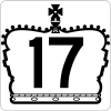
 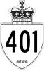   Highway markers for King's Highway 17, King's Highway 401, Secondary Highway 600, and Tertiary Highway 800 | |
| System information | |
| Maintained by the MTO | |
| Length | 16,900 km[2][GIS 1] (10,500 mi) |
| Formed | February 26, 1920[1] |
| Highway names | |
| Types |
|
| System links | |
The Provincial Highway Network consists of all the roads in Ontario maintained by the Ministry of Transportation of Ontario (MTO), including those designated as part of the King's Highway, secondary highways, and tertiary roads. Components of the system—comprising 16,900 kilometres (10,500 mi) of roads and 2,880 bridges[GIS 1] —range in scale from Highway 401, the busiest highway in North America, to unpaved forestry and mining access roads. The longest highway is nearly 2,000 kilometres (1,200 mi) long, while the shortest is less than a kilometre. Some roads are unsigned highways, lacking signage to indicate their maintenance by the MTO; these may be remnants of highways that are still under provincial control whose designations were decommissioned, roadway segments left over from realignment projects, or proposed highway corridors.
Predecessors to today's modern highways include the foot trails and portages used by indigenous peoples in the time before European settlement. Shortly after the creation of the Province of Upper Canada in 1791, the new government under John Graves Simcoe built overland military roads to supplement water-based transportation, including Yonge Street and Dundas Street. At the time, road construction was under the control of the township and county governments. Local township roads were financed and constructed through a statute labor system that required landowners to make improvements in lieu of taxes. Private companies constructed corduroy and later plank roads and charged tolls in the second half of the 19th century. The rising popularity of the bicycle led to the formation of , which advocated for the improvement of roads and recreation as the automobile rose to prominence.
By the early 20th century, the province had taken interest in road improvement and began funding it through counties. The increasing adoption of the automobile resulted in the formation of the Department of Public Highways of Ontario (DPHO) in 1916. The passing of the Canada Highways Act in 1920 resulted in the establishment of a provincial network of highways. The DPHO assigned internal highway numbers to roads in the system, and in 1925, the numbers were signposted along the roads and marked on maps. In 1930, provincial highways were renamed King's Highways and the familiar crown route markers created. The DPHO was also renamed the Department of Highways (DHO).
The 1930s saw several major depression relief projects built by manual labour, including the first inter-city divided highway in North America along the Middle Road, which would become the Queen Elizabeth Way in 1939. In 1937, the DHO merged with the Department of Northern Development, extending the highway network into the Canadian Shield. Significant traffic engineering and surveying through the war years, during which construction came to a near standstill, led to the planning and initial construction of controlled-access highways. The 400-series highways were built beginning in the late 1940s and numbered in 1952.
The vast majority of modern road infrastructure in Ontario was built throughout the 1950s, 1960s, and early 1970s. The cancellation of the controversial Spadina Expressway and the introduction of the Environmental Assessment Act in the 1970s resulted in a decline in new highway construction in the decades since. In the late 1990s, nearly 5,000 kilometres (3,100 mi) of provincial highways were transferred, or "downloaded" back to lower levels of government. Few new provincial highways have been built in the early years of the 21st century, although several major infrastructure projects including the Herb Gray Parkway and expansion of Highway 69 have proceeded.

Naming, signage and regulations[]
In Ontario, all public roads are legally considered highways under the Highway Traffic Act (HTA), which sets forth regulations for traffic, or the rules of the road.[3] The Public Transportation and Highway Improvement Act (PTHIA) sets forth the regulations concerning roads that are under the authority of the Province of Ontario. The act distinguishes and sets out the applicability of the HTA to provincial highways, which are designated as part of The King's Highway (primary), a secondary highway, or a tertiary road. Tertiary roads may also be designated as a resource road, allowing for vehicles otherwise prohibited from public roads. Industrial roads are privately owned routes with which the MTO has entered an agreement to improve or allow public access, and are not considered part of the provincial highway network.[4] The 407 ETR is likewise not considered part of the provincial highway network. While it is still subject to the rules set forth by the HTA, it is otherwise governed independently under the legislation of the Highway 407 Act.[5]
Speed limits on provincial highways are legislated by sections of the road, and vary between 50 km/h (30 mph) and 110 km/h (70 mph). Freeways, including the 400-series highways, are generally signed at 100 km/h (60 mph), although sections exist that are signed lower.[6][GIS 2] Three segments of freeway are part of an ongoing pilot project to test speed limits of 110 km/h in rural areas that are not subject to congestion. A fourth segment, located in Northern Ontario, was set to be announced in 2020, but has been delayed since.[7]
Marker design[]

Ontario uses two distinct shapes of signage to mark the King's Highways. Confirmation markers, or reassurance markers, are utilised along the designated road to confirm (near intersections) or reassure (elsewhere) drivers that they are on the correct route. The markers, known eponymously as shields, feature the route number within an outline in the shape of a shield, topped by a St Edward's Crown. In other cases, particularly when denoting the designation of an intersecting numbered road, a crown marker is used, featuring the route number within an outline of the St Edwards Crown. For secondary highways, the route number is within an outline of an isosceles trapezoid, while tertiary roads place the number within an outline of a rectangle. When these markers appear along or at an intersection with the indicated highway, they feature black text on a reflective white background. There are two exceptions to this: The QEW, which features blue text on a reflective yellow background; and toll highways, which feature white text on a reflective blue background. Signs prior to 1993 had the words "The King's Highway" below the crown, but current versions have the words removed.[8]
In addition to regular highway markers, there are trailblazers, which indicate a route towards that highway. These are the same shape as their corresponding highway marker. Trailblazers for the King's Highway feature white text on a reflective green background, with the exception of trailblazers for the QEW, which feature yellow text on a reflective blue background. For secondary highways, trailblazers simply add the word "TO" above the route number.[8]
Since August 2004, "Highway of Heroes" shields featuring a diagram of a poppy have been posted along Highway 401 between Toronto and CFB Trenton. These were erected to honour fallen Canadian soldiers, whose bodies were repatriated from Afghanistan in funeral convoys along that stretch of the highway.[9]


Classification[]
Ontario has several distinct classes of highways:[GIS 3]
The King's Highway[]

The King's Highway is the primary highway network of Ontario, and constitutes the majority of the principal inter-urban roadways in the province. As a whole, it is referred to in the singular form as opposed to as a group of its parts (i.e. "the King's Highway", not "the King's Highways").[4][6] Individual highways are known as "part of the King's Highway" or "the King's Highway known as n".[6][10] However, in common parlance they are simply referred to as "Highway n".[11] Ontario highways ranks fourth in North America for fatality rates, with 0.61 fatalities per 10,000 licensed drivers in 2017.[12]
The 400-series highways and the QEW form the backbone of the King's Highway, with other routes numbered from 2 to 148.[2] The Ministry of Transportation never designated a Highway 1.[13] Some highway numbers are suffixed with a letter A ("alternate route"),[14] B ("business route"),[15] or N ("new route").[16] In the past, there have also been routes with C and S ("scenic route") suffixes.[17][18] The entire King's Highway network is fully paved.[14] The term "the King's Highway" was first adopted in place of "provincial highway" in 1930, and signs similar to the current design replaced the previous triangular signs at that time.[19][20] Some legislative acts refer to roads that are under the jurisdiction of the province as "provincial highways".[21]
400-series[]
The 400-series highways are a network of controlled-access highways throughout the southern portion of Ontario, forming a special subset of the provincial highway network. They are analogous to the Interstate Highway System in the United States or the Autoroute system of neighbouring Quebec, and are regulated by the MTO.[22] The 400-series designations were introduced in 1952, although Ontario had been constructing divided highways for two decades prior.[23] Initially, only Highways 400, 401 and 402 were numbered; other designations followed in the subsequent decades.[24]
While older freeways have some lapses in safety features, contemporary 400-series highways have design speeds of 130 km/h (81 mph), speed limits of 100 km/h (62 mph), various collision avoidance and traffic management systems, and several design standards adopted throughout North America.[25] Of note are the Ontario Tall Wall median barrier and the Parclo A-4 interchange design, the latter which became standard in the design for the widening of Highway 401 through Toronto in 1962. The Institute of Traffic Engineers subsequently recommended this design to replace the cloverleaf interchange throughout North America.[26][27]
Secondary[]

Secondary highways exist solely within the districts of Northern Ontario that lack a county road system, to which they are analogous. The sole exception to this is Highway 537 in Greater Sudbury. They generally serve to connect remote communities to the King's Highway, or to interconnect the King's Highway. A few secondary highways remain gravel-surfaced, although most have been paved.[14] The speed limit on nearly all of these routes is 80 km/h (50 mph), although Highway 655 is posted at 90 km/h (55 mph).[6]
The Secondary Highway system was introduced in 1956 to service regions in Northern and Central Ontario, though it once included a route as far south as Lake Ontario. Many routes that would become secondary highways were already maintained by the province as development roads prior to being designated.[28][29] Since 1998, none have existed south of the districts of Parry Sound and Nipissing.[30] Secondary highways are numbered in the 500s and 600s, with existing highways numbered between 502 and 673.[2][28]
Tertiary[]
Tertiary roads are remote routes entirely within Northern Ontario that provide access to resources (e.g. mining and forestry). Tertiary roads are numbered in the 800s, with the five existing highways numbered between 802 and 811. Most of these roads are gravel-surfaced and of low-standard. The speed limit on these routes is 80 km/h (50 mph), although design standards generally prevent such.[14][6] Unlike other roads in the Provincial Highway Network, the MTO is not responsible for winter maintenance nor liable for damage incurred as a result of using these routes.[4] The MTO introduced the Tertiary Road system in 1962. With the exception of Highway 802, none end in settlements.
Trans-Canada[]

The Trans-Canada Highway (TCH) forms several major routes across Canada. The provincial governments are entirely responsible for signage and maintenance of the routes, except through National Parks. It is signed with distinctive green markers with a white maple leaf on them throughout Canada. While other provinces generally place a highway number within the maple leaf of the TCH marker (with a shared "Highway 1" designation across the western provinces), Ontario places them below or beside provincial shields and either leaves them blank or inserts a name instead; these are the Central Ontario Route, Georgian Bay Route, Lake Superior Route, Northern Ontario Route and Ottawa Valley Route.
Several portions of King's Highways are designated as part of the Trans-Canada Highway system within Ontario, with the TCH having a main route and several branches, often only following sections of any given provincial highway. They are:

 Highway 7 (Section as branch)
 Highway 11 (2 sections as branches)
 Highway 12 (Section as branch)
 Highway 17 (Entire length as main route)
 Highway 66 (Section as branch)
 Highway 69 (Entire length as branch)
 Highway 71 (Entire length as branch)
 Highway 400 (Section as branch)
 Highway 417 (Entire length as main route; freeway continuation of Highway 17)
Others[]
In addition to these classes of highways, the MTO maintains other roads, such as resource roads or industrial roads, that are of strategic importance to the provincial government. These roads are designated with 7000-series numbers for internal inventory purposes, though they are not publicly marked as such. They are often, but not always, former highway segments which were decommissioned as a King's Highway, but remain important as connecting routes to communities or other highways in areas without municipal governance.[14]
There were formerly several designated Ontario Tourist Routes that were located throughout the entire province.[31] However, beginning in February 1997, Tourism-Oriented Directional Signs (TODS) began to appear on highways.[32] Tourist Routes no longer appeared on maps after 1998.[30]
History[]

Before 1791: Native footpaths[]
Prior to the arrival of Europeans in the 17th century, transportation across what became Ontario was generally via the thousands of lakes and rivers. Short trails existed between bodies of water, known as a portage or carrying place, as well as along the shorelines of the larger lakes.[33] In 1615, French explorer Samuel de Champlain was the first European to pass through the lands between the Great Lakes, accompanied by Huron and Iroquois guides. His emissary Étienne Brûlé as well as Franciscan Récollets such as Joseph Le Caron and Joseph de La Roche Daillon were the first to explore various lands of the area, all with the assistance of the local First Nations.[34][35][36] For the next 150 years, France and Britain wrestled for control of the colony of Canada while simultaneously exploiting the land for the fur trade of North America.[33] This culminated in the global Seven Years' War that ended with the signing of the Treaty of Paris in 1763, which ceded Canada to the British.[37]
The colony of Canada was renamed the Province of Quebec until 1791, when it was divided into Upper Canada (modern Southern Ontario) and Lower Canada (modern Southern Quebec) by the Constitutional Act.[38] This was done to provide a British-style governance to the United Empire Loyalists fleeing north following the American Revolution.[39] In addition to the native portages and lake shore trails, routes developed alongside significant rivers such as the St. Lawrence, Ottawa, Humber and Grand Rivers. These meandering trails followed the lay of the land, as opposed to the straight tangents of the surveyed roads yet to come. Some roads in Ontario still closely follow these early Native and European trails,[40][41] including the Kente Portage Trail (Old Portage Road) in Carrying Place, the oldest continuously-used road in the province.[42]
1792–1866: Settlement of Upper Canada[]
The Spit of Land which forms its Entrance is capable of being fortified with a few heavy Guns as to prevent any Vessel from entering the Harbour or from remaining within it. ... I have good Information that a Road is very easy to be made to communicate with those Waters which fall into Lake Huron. ... In regard to Lake Huron, tho' it is not so immediate an object of Attention, yet I consider it ultimately of the most extensive and serious Magnitude.
John Graves Simcoe[43]
John Graves Simcoe, the first Lieutenant Governor of Upper Canada, landed at Niagara on July 26, 1792, after overwintering in Quebec City,[44] from England and set forth to colonize the province in the image of Britain.[45] The ambitious abolitionist statesman, whom served the British during the American Revolutionary War, was appointed to lead the new colony on September 12, 1791.[46] Although Niagara-on-the-Lake (then known as Newark) served as the capital for a year, Simcoe moved it to what is now Toronto after July 30, 1793, at the behest of French merchant Philippe de Rocheblave,[47] following the arrival of news in May of France's declaration of war against Britain.[45]
Having reformed the Queen's Rangers, whom he fought alongside during the American War, Simcoe set out to establish military roads to connect his new capital with the Upper Great Lakes and other strategic points.[48] The first road he ordered built was Dundas Street, from the head of Lake Ontario near present day Dundas to the forks of the Thames River in present day London. His Rangers began work on this route on September 10, 1793.[49] Between September 25 and October 14, Simcoe travelled with native guides to Penetanguishene and back. Following the advice of an Ojibwa named Old Sail, the return voyage followed the east branch of the Holland River and thence south to Toronto (known as York from 1793 to 1834); this would become the route of Yonge Street.[50]

Simcoe's Rangers would commence "run[ning] the line of the new road" with Surveyor General Augustus Jones in February 1794.[51] By mid-May, the Rangers had cleared and marked 14 lots from Eglinton Avenue to just north of Sheppard Avenue before being redirected to defend Fort Miami. William Berczy — and the nearly 200 Pennsylvania Dutch settlers whom accompanied him from the US into Upper Canada in July 1794 — would complete the opening of the route to Bond Lake by the end of 1794. The remainder to Holland Landing was opened by the Queen's Rangers, under the supervision of Augustus Jones, between December 28, 1795, and February 16, 1796.[52]
The majority of settlers up to this point were United Empire Loyalists — settlers of the Thirteen Colonies loyal to Britain who fled north to the new colony. These pioneers endured starting anew in untamed wilderness, with little provisions beyond what they could carry.[53] Many were strategically placed along Yonge Street and Dundas Street, and given the duty of clearing half the width of a road along the front of their property lot; the lot frontages were a 1⁄4 mile (400 m) and the full road width was a chain (66 feet or 20 metres).[54] However, many lots were given to absent clergymen and English nobles, resulting in these "roads" being poorly-maintained quagmires of mud.[55]
- Hiring of Asa Danforth to build a road to Kingston in 1896.[56]
- War of 1812
- Talbot Settlement and Canada Company
- Mackenzie Rebellion (1837)
- Statute labour and township road system
They were also given the option of volunteering 12 days of statute labour in lieu of paying taxes.
During the early 1800s, the government of Upper Canada appropriated settlers to various lots which had been surveyed along the lake shores of Lake Erie and Lake Ontario. The townships established along these fronts contained generally fertile land composed of glacial till and clay-rich loam. As these townships filled up, business opportunities presented themselves for investors to purchase native lands and open them to settlement. The Canada Company was the most successful of these ventures and brought settlers to vast areas of land in Western Ontario by building routes such as Huron Road and Toronto–Sydenham Road during the 1830s and 1840s.[57]
1867–1893: Colonization roads and the railway[]
- Colonization roads
As the second township frontage along Lake Ontario also filled, the government came under pressure to open up the unforgiving terrain of the Canadian Shield to settlement and sought to establish a network of east–west and north–south roads between the Ottawa Valley and Georgian Bay. This area was known as the .[58]
In 1847, an exploration survey was carried out by Robert Bell to lay out the lines that would become the Opeongo, Hastings, and Addington Roads. The Public Lands Act, passed in 1853, permitted the granting of land to settlers who were at least 18. Those settlers who cleared at least 12 acres (49,000 m2) within four years, built a house within a year, and resided on the grant for at least five years would receive the title to that land. The government subsequently built over 1,600 kilometres (1,000 mi) of roads over the following 20 years to provide access to these grants.[59]
- the railway
- Statute labour gradually abolished, starting with Malden Township in March 1890.[60]
1894–1915: The "Good Roads" movement[]
- Dr. Doolittle
- Campbell
- Provincial Instructor in Road Making was appointed in 1896 in the Department of Agriculture, became Commissioner of Public Highways in 1900, became the Deputy Minister in the Department of Public Works in 1905
- First legislation (inc. speed limits) and licence plates issued in 1903
- Major focus on roads following production of Model T in 1908
- Toronto–Hamilton Highway (Lakeshore Road) begun 1914
1916–1933: The first paved highways[]
- Department of Public Highways of Ontario (DPHO) established on January 17, 1916
- Lakeshore Road 1917
- Kingston Road and Prescott Highway 1918
- Until 1918, the majority of the primary roads through southern Ontario formed part of the County Road System. The Department of Public Works paid up to 60% of the construction and maintenance costs for these roads, while the counties were responsible for the remaining 40%. In 1919, the federal government passed the Canada Highways Act, which provided $20,000,000 to provinces under the condition that they establish an official highway network; up to 40% of construction costs would be subsidized. The first network plan was approved on February 26, 1920.[61]
- Provincial Highway Network established February 1920
- Numbered in 1925
- Ferguson Highway 1928
- Provincial Highways become The King's Highway in 1930, DPHO becomes DHO in 1931
- Construction of four-lane Middle Road, and other depression-relief projects, begins in 1931
- 1934 election brings Mitch Hepburn to power, with visionary Thomas Baker McQuesten as Highways Minister
1934–1948: Dual highways and the Queen Elizabeth Way[]
- Inspired by Autobahns, Middle Road redesigned into divided four-lane highway beginning in 1934
- Canada's first interchange at Hurontario
- Several other dual highways constructed beginning in 1936/37, including many section of Highway 2.
- Widening of Kingston Road to a dual highway, which began with the junction with Danforth Avenue, began in 1936 and progressed towards the Highland Creek valley. Beyond that point, the dual highway was built on a new alignment to Oshawa, the first part of what would become Highway 401.
- QEW dedicated in 1939, "completed" in 1940
- War slowed construction due to labour and material shortages, but advances in machinery more than made up for the lost time.
- Toronto–Barrie Highway started in 1946
1950–1971: The freeway age and the Trans-Canada Highway[]
When Ontario signed the Trans-Canada Highway Agreement on April 25, 1950, it had already chosen a Central Ontario routing;[62] Highway 17 through the Ottawa Valley was announced as a provincially-funded secondary route of the Trans-Canada the following day.[63]
The construction boom following the war resulted in many new freeway construction projects in the province. The Toronto–Barrie Highway, Trans-Provincial Highway,[24] a short expansion of Highway 7 approaching the Blue Water Bridge in Sarnia (Highway 402),[64] and an expansion of Highway 27 (eventually designated as Highway 427 by the mid-1970s) into part of the Toronto Bypass were all underway or completed by the early 1950s.[24] Seeking a way to distinguish the controlled-access freeways from the existing two-lane King's Highways, the Department of Highways created the 400-series designations in 1952. By the end of the year, Highway 400, 401, and 402 were numbered, although they were only short stubs of their current lengths.[65] Highway 401 was assembled across the province in a patchwork fashion,[24] becoming fully navigable between Windsor and the Quebec border on November 10, 1964;[66] Highway 400 was extended north to Coldwater on Christmas Eve 1959;[67] Highway 402 was extended to London between 1972 and 1982.[68][69]
In addition to this network backbone, plans for additional 400-series highways were initiated by the late 1950s, comprising the Chedoke Expressway (Highway 403) through Hamilton;[70] the Don Valley Parkway Extension (Highway 404) northward from the soon-to-be constructed Toronto expressway;[71] Highway 405 to connect with the American border near St. Catharines;[72] Highway 406 south from St. Catharines to Welland;[73] Highway 407 encircling the Greater Toronto Area (GTA), though not built for another 40 years;[74] Highway 409 to connect Highway 401 with Toronto International Airport;[75] and The Queensway (Highway 417) through Ottawa.[76] The first sections of these freeways were opened in 1963,[77] 1977,[78] 1963,[77] 1965,[79] 1997,[80] 1974,[81] and 1960,[82] respectively.
1972–1996: Growth of public transit[]
1997–1998: Highway Transfers[]
As part of a series of budget cuts initiated by premier Mike Harris under his Common Sense Revolution platform in 1995, numerous highways deemed to no longer be of significance to the provincial network were decommissioned and responsibility for the routes transferred to lower levels of government, a process referred to as downloading. Several thousand kilometres of provincially maintained highways were transferred to the various municipalities in which they are located. These transfers were performed under the reasoning that they served a mostly local function, as a cost-saving measure and as part of a broader exchange of responsibilities between the province and its municipalities.
On April 1, 1997, 1,767.6 kilometres (1,098.3 mi) of highways were removed from the King's Highway system.[83] This was followed by the removal of 3,211.1 kilometres (1,995.3 mi) on January 1, 1998,[84] for a total of 4,978.7 kilometres (3,093.6 mi).
See also[]
References[]
Footnotes[]
- ^ Shragge & Bagnato 1984, pp. 74–75.
- ^ Jump up to: a b c Ministry of Transportation of Ontario (2016). "Annual Average Daily Traffic (AADT) counts". Retrieved March 13, 2021.
- ^ "Highway Traffic Act; R.S.O. 1990, Chapter H.8, s. 1". e-Laws. Government of Ontario. Retrieved March 8, 2021.
- ^ Jump up to: a b c "Public Transportation and Highway Improvement Act; R.S.O. 1990, Chapter P.50, parts I–VI". e-Laws. Government of Ontario. Retrieved March 8, 2021.
- ^ "Highway 407 Act; S.O. 1998, Chapter 28, s. 12". e-Laws. Government of Ontario. Retrieved March 8, 2021.
- ^ Jump up to: a b c d e "Speed Limits; R.R.O. 1990, Reg. 619, s. 1; O. Reg. 319/19, s. 1". e-Laws. Government of Ontario. Retrieved March 8, 2021.
- ^ "Ontario's Increased Speed Limit Pilot Finds Wide Public Support". Government of Ontario. March 11, 2020. Retrieved March 8, 2021.
- ^ Jump up to: a b Ministry of Transportation of Ontario (May 2010). Ontario Traffic Manual, Book 8, Volume 1 - Guide and Information Signs (PDF). 1. Government of Ontario. Retrieved March 8, 2021.
- ^ "Stretch of 401 to be renamed 'Highway of Heroes'". CTV Toronto. August 24, 2007. Archived from the original on January 6, 2011. Retrieved February 3, 2010.
- ^ "Restricted Use of the King's Highway; R.R.O. 1990, Reg. 609, s. 1". e-Laws. Government of Ontario. Retrieved March 8, 2021.
- ^ "Traveller Road Information Portal". Ontario 511. Retrieved March 8, 2021.
- ^ Road Safety Policy Office - Vehicles (2017). "Overview" (PDF). Ontario Road Safety Annual Report (Report). Government of Ontario. p. 21. ISSN 1710-2480. Retrieved March 7, 2021.
- ^ "Provincial Highways Now Being Numbered". The Canadian Engineer. Monetary Times Print. 49 (8): 246. August 25, 1925.
Numbering of the various provincial highways in Ontario has been commenced by the Department of Public Highways. Resident engineers are now receiving metal numbers to be placed on poles along the provincial highways. These numbers will also be placed on poles throughout cities, towns and villages, and motorists should then have no trouble in finding their way in and out of urban municipalities. Road designations from "2" to "17" have already been alloted...
- ^ Jump up to: a b c d e IBI Group (November 2016). Draft Technical Backgrounder: Highways and Roads (PDF) (Report). Ministry of Transportation of Ontario. p. 8. Retrieved March 9, 2021.
- ^ "Alternate Highway 17 Starts West End Fight". The Ottawa Citizen. 123 (903). September 22, 1965. p. 3. Retrieved March 9, 2021 – via Newspapers.com.
- ^ MMM Group (April 9, 2014). Highway 7 New Kitchener to Guelph, 18 km, G.W.P. 408-88-00 – Initial Design Report (2014) (PDF) (Report). Ministry of Transportation of Ontario. Retrieved March 9, 2021.
- ^ Lewis, Malcolm R. (September 1964). A Geographical Study of Bertie Township (Thesis). McMaster University. Retrieved March 9, 2021.
- ^ "A Forest of Highway Signs". The Ottawa Journal. September 21, 1948. p. 4. Retrieved January 19, 2021 – via Newspapers.com.
- ^ Don W. Thompson (1969). Men and Meridians: The History of Surveying and Mapping in Canada – 1917 to 1947. 3. Canadian Government Publishing Centre. p. 141. ISBN 0-660-00359-7.
- ^ Canadian Press (March 20, 1930). "Convicted Drivers may be Compelled to Take Insurance". The Gazette. 159 (68). Montreal. p. 21. Retrieved March 7, 2021 – via Newspapers.com.
- ^ "Municipal Act, 2001; SO 2001, c. 25". e-Laws. Government of Ontario. Retrieved March 8, 2021.
- ^ Rzeznikiewiz, Damian; Tamim, Hala; Macpherson, Alison K. (December 28, 2012). "Risk of Death in Crashes on Ontario's Highways". BMC Public Health. 12: 1125. doi:10.1186/1471-2458-12-1125. PMC 3543722. PMID 23273001.
- ^ "Hopes to Improve Roads". The Gazette. Montreal. February 18, 1936. p. 14. Retrieved February 9, 2010.
- ^ Jump up to: a b c d Shragge, John G. (2007). "Highway 401: The Story". Archived from the original on March 28, 2008. Retrieved February 12, 2010.
- ^ Revie, Nancy (September 19, 2005). "An Expressway in Name Only". The Guelph Mercury. p. A9.
- ^ Proceedings ... Annual Meeting (Report). Institute of Traffic Engineers. 1962. pp. 100–103.
- ^ "Partial Cloverleaf Interchange (Parclo)". The Canadian Design Resource. Retrieved June 4, 2015.
- ^ Jump up to: a b "Ontario Secondary Roads Now Designated 500, 600". 112 (33, 119). The Globe and Mail. February 4, 1956. p. 4.
Two new Ontario road numbers appear on the province's 1956 official road map which will be ready for distribution next week. The new numbers are the 500 and 600 series and designate hundreds of miles of secondary roads which are wholly maintained by the Highways Department. More than 100 secondary roads will have their own numbers and signs this year. All of these secondary roads were taken into the province's main highways system because they form important connecting links with the King's Highways
- ^ Ontario Road Map (Map). Cartography by C.P. Robins. Ontario Department of Highways. 1957. §§ R38–39.
- ^ Jump up to: a b Ontario Road Map (Map). Cartography by Geomatics Office. Ministry of Transportation. 1999. Retrieved March 9, 2021 – via Archives of Ontario.
- ^ Ontario Road Map (Map). Cartography by Surveys and Mapping Section. Ministry of Transportation. 1998. Retrieved February 15, 2021.
- ^ Antler, Jim (1997). "New Tourism Sign System Unveiled". The Outfitter. No. March/April. Nature and Outdoor Tourism Ontario. pp. 15–18. Retrieved March 13, 2021.
- ^ Jump up to: a b Bradford 2015, Roads and Transportation in Upper Canada Before 1800.
- ^ Mansfield, J. B. (1899). History of the Great Lakes. I. Chapter 6: French Discovery and Occupation: J. H. Beers & Co. Retrieved March 14, 2021.CS1 maint: location (link)
- ^ Deziel, Paul (November 10, 1934). "Historic Shores of River St. Clair". The Border Cities Star. p. 1, Section Three. Retrieved February 27, 2021 – via Newspapers.com.
- ^ O’Gorman, John J. (March 1916). "Ontario's Pioneer Priest". No. 102. Catholic World. pp. 751–756. Retrieved March 14, 2021. Cite magazine requires
|magazine=(help) - ^ "His Most Christian Majesty cedes and guaranties to his said Britannick Majesty, in full right, Canada, with all its dependencies, as well as the island of Cape Breton, and all the other islands and coasts in the gulph and river of St. Lawrence, and in general, every thing that depends on the said countries, lands, islands, and coasts..." – via Wikisource.
- ^ "Constitutional Act (1791)". University of Ottawa – Compendium of Language Management in Canada (CLMC). Retrieved March 15, 2021.
- ^ "Historical Documents". Constitution 150. Retrieved March 15, 2021.
- ^ Henderson, Bob; Bermingham, Patrick. "The Dundas Portage: Exploring the Logic of Trails" (PDF). Ontario Professional Surveyor. No. Summer 2008. pp. 10–14. Retrieved March 15, 2021 – via Krcmar Surveyors.
- ^ Ministry of Transportation. "History of Ministry of Transportation". www.mto.gov.on.ca. Government of Ontario. Retrieved March 15, 2021.
- ^ Harvey, Garrett (May 1, 2019). "The Oldest Road in Ontario". Bay of Quinte Region. Retrieved March 28, 2021.
- ^ Berchem 1977, p. 11.
- ^ Mutrie, Ronald Robert (1992). "Lieutenant Governor Simcoe's Strategy". The Long Point Settlers. Log Cabin Books. ISBN 978-0969281245. Retrieved March 28, 2021.
- ^ Jump up to: a b Berchem 1977, p. 10.
- ^ Toby Barrett (September 28, 2017). "Simcoe Day Act, 2017, Bill 159" (PDF). Parliamentary Debates (Hansard). Ontario: Legislative Assembly of Ontario. pp. 5359–5366. Retrieved March 28, 2021.
- ^ Berchem 1977, pp. 14–16.
- ^ Berchem 1977, p. 15.
- ^ Legislative Assembly of Ontario 1896, p. 31.
- ^ Berchem 1977, pp. 16–20.
- ^ Berchem 1977, pp. 20–21.
- ^ Berchem 1977, pp. 21–24, 29, 35.
- ^ Berchem 1977, pp. 38–39.
- ^ Berchem 1977, p. 29.
- ^ Burghardt, Andrew F. (1969). "The Origin and Development of the Road Network of the Niagara Peninsula, Ontario, 1770–1851". Annals of the Association of American Geographers. 59 (3): 417–440. doi:10.1111/j.1467-8306.1969.tb00683.x. ISSN 0004-5608.
- ^ https://schoolweb.tdsb.on.ca/Portals/tusc/docs/sss_resource.pdf
- ^ Shragge & Bagnato 1984, pp. 31, 40.
- ^ Shragge & Bagnato 1984, p. 17.
- ^ Shragge & Bagnato 1984, pp. 17–19.
- ^ Legislative Assembly of Ontario (1897). Report of the Provincial Instructor in Road-Making. Ontario Department of Agriculture. p. 15. Retrieved March 28, 2021.
The township of Malden, Essex county, is the only township municipality which has yet completely abolished the statute labor system. The change was made in March 1890.
- ^ Shragge & Bagnato 1984, pp. 73–75.
- ^ Baldwin, Warren (April 25, 1950). "Six Sign Road Pact After Ontario Given Concession". The Globe and Mail. p. 1. ProQuest 1291203460. Retrieved April 12, 2021.
- ^ "Highway No. 17 Secondary Link Of Trans-Canada". The Globe and Mail. April 26, 1950. p. 7. ProQuest 1291386930. Retrieved April 12, 2021.
- ^ Built Heritage, Cultural Landscape and Planning Section (January 2006). "2.0 Background History" (PDF). Heritage Impact Assessment: Christina Street Bridge over Highway 402, Sarnia (Report). Archaeological Services Inc. p. 4. Retrieved January 6, 2014.
- ^ Walter, Karena (February 21, 2014). "Search Engine: Highway Mysteries Solved". The Niagara Falls Review. Archived from the original on December 22, 2015. Retrieved December 17, 2015.
- ^ Ministry of Transportation and Communications (1972), pp. 8–9.
- ^ "Open 400 Link to Coldwater". The Toronto Star. December 24, 1959. p. 18.
The new, 22-mile extension from south of Crown Hill to Coldwater will be ready for traffic this afternoon.
- ^ Highway Construction Program: King's and Secondary Highways. Ministry of Transportation and Communications. 1972–1973. p. xi.
- ^ Annual Report (Construction ed.). Ministry of Transportation and Communications. 1982–1983. p. 76.
- ^ Annual Report for the Fiscal Year (Report). Ontario Department of Highways. March 31, 1958. Retrieved July 25, 2010.
- ^ Don Valley Parkway Extension, Highway 401 to Steeles Avenue (Report). Desjardines. 1957.
- ^ "Above the Regular Budget". The Ottawa Citizen. July 31, 1958. p. 7. Retrieved October 20, 2010.
- ^ Annual Report. Department of Highways. March 31, 1961. Retrieved July 29, 2011.
- ^ Sewell, John (2009). The Shape of the Suburbs: Understanding Toronto's Sprawl. University of Toronto Press. p. 72. ISBN 978-0-8020-9884-9. Retrieved July 1, 2010.
- ^ Hicks, Kathleen A. (2006). "Road Controversy - 1968". Malton: Farms to Flying (PDF). Friends of the Mississauga Library System. pp. 208–209. ISBN 0-9697873-9-1. Retrieved April 4, 2010.
- ^ Robertson, Peter. "The Queensway Began with a Royal Blast: Flashback to 1957". Carlington Community Association. Archived from the original on April 26, 2012. Retrieved December 17, 2015.
- ^ Jump up to: a b Ontario Department of Highways (1970), p. 11.
- ^ Construction Program: King's and Secondary Highways (Report). Ministry of Transportation and Communications. 1976–77. p. XV.
- ^ Ontario Department of Highways (1970), p. 12.
- ^ Settlement of Claim of Richard Prendiville (PDF) (Report). Ontario Superior Court of Justice. December 12, 2001. p. 7. Archived from the original (PDF) on July 27, 2014. Retrieved December 17, 2015.
- ^ Construction Program: King's and Secondary Highways (Report). Ministry of Transportation and Communications. 1976–77. p. XIV.
- ^ Clark, Glenn (April 14, 2012). A Historical Timeline for the Township of Gloucester. The Gloucester Historical Society. Retrieved July 1, 2012.
- ^ Highway Transfers List (Report). Ministry of Transportation of Ontario. April 1, 1997.
- ^ Highway Transfers List - "Who Does What" (Report). Ministry of Transportation of Ontario. June 20, 2001.
- ^ Ibbitson, John (February 1, 1997). "Rough Roads Ahead Under Tories". The Ottawa Citizen. p. E10. Retrieved March 13, 2021.
- ^ Boswell, Randy (July 21, 1997). "On A (Back) Road to Ruin?". City. The Ottawa Citizen. p. B3. Retrieved March 13, 2021.
Bibliography[]
- Berchem, F.R. (1977). The Yonge Street Story: 1793–1860. McGraw-Hill Ryerson. ISBN 0-07-082567-X.
- Bradford, Robert (2015). Keeping Ontario Moving: The History of Roads and Road Building in Ontario. Dundurn Press. ISBN 978-1-4597-2412-9.
- Legislative Assembly of Ontario (1896). Appendix to the Report of the Ontario Bureau of Industries. Retrieved March 28, 2021.
- Shragge, John; Bagnato, Sharon (1984). From Footpaths to Freeways. Historical Committee, Ministry of Transportation and Communications. ISBN 978-0-7743-9388-1.
- Stamp, Robert M. (1987). QEW – Canada's First Superhighway. The Boston Mills Press. ISBN 0-919783-84-8.
GIS datasets[]
- ^ Jump up to: a b Ministry of Transportation of Ontario Geomatics Office; Land Information Ontario (December 10, 2020). "Ontario Road Network - Ontario Provincial Highways". ArcGIS.com. Retrieved March 8, 2021.
- ^ Ministry of Transportation of Ontario Geomatics Office; Land Information Ontario (May 7, 2020). "Speed Limits in Ontario". ArcGIS.com. Retrieved March 8, 2021.
- ^ Ministry of Transportation of Ontario Geomatics Office; Land Information Ontario (November 13, 2019). "Ontario Road Network - MTO Jurisdiction by Highway Shield Type". ArcGIS.com. Retrieved March 14, 2021.
External links[]
| Wikimedia Commons has media related to Highways in Ontario. |
- Ministry of Transportation of Ontario (MTO)
- MTO 100th Anniversary - History
- Official Ontario road map
- Ontario 511 Traveller Information - Highway conditions
- Ontario's Highway Programs
- Road maps of Ontario, 1923–2010


| hide Provincial and territorial highways in Canada | |
|---|---|
|
- Ontario provincial highways
- Lists of roads in Ontario
- 1920 establishments in Ontario