Ontario Highway 11A
 | ||||
|---|---|---|---|---|
| Avenue Road University Avenue York Street | ||||
 A map of Highway 11A Highway 11A Former route replaced by Highway 401 in 1952 | ||||
| Route information | ||||
| Auxiliary route of Highway 11 | ||||
| Maintained by City of Toronto | ||||
| Length | 12.4 km[1] (7.7 mi) | |||
| Existed | January 21, 1931–January 15, 1954 | |||
| Major junctions | ||||
| South end | ||||
| North end | ||||
| Location | ||||
| Major cities | Toronto | |||
| Highway system | ||||
| ||||
| ||||
King's Highway 11A, commonly referred to as Highway 11A, was the highway designation for an alternate route of Highway 11 in the Canadian province of Ontario. The north-south route paralleled Highway 11 (Yonge Street) within Toronto, serving as a secondary access to Downtown Toronto. It began at the York exit of the Gardiner Expressway (Highway 2) and travelled north on York Street to Front Street, where it transitioned onto University Avenue. It continued north on University Avenue to Queen's Park, where Highway 11A followed Queen's Park Crescent, encircling the Ontario Legislative Building, before continuing along Avenue Road. Highway 11A travelled along Avenue Road to Upper Canada College. It followed Lonsdale Road, Oriole Parkway, and Oxton Avenue around the campus and back to Avenue Road, which resumes north of the school. It continued north along Avenue Road to Highway 401, ending just north of the highway at Bombay Avenue.
Highway 11A was established in 1930, when the province built an extension of Avenue Road north from the city limits of the old City of Toronto to complete a parallel alternative to Highway 11. It connected to that route via the Hogg's Hollow Bridge, which had been completed the previous year to provide a level detour of the deep ravine of the West Don River. Although the within old Toronto were not maintained by the province, they were signed as part of the highway regardless. The Hogg's Hollow Bridge was incorporated into Highway 401 upon its completion in 1952, truncating Highway 11A at the interchange with the new freeway. When Metropolitan Toronto was formed in 1953, most provincial routes within its boundaries, including Highway 11A, were transferred to it. Although the highway was decommissioned in early 1954, it continued to be signed until the late 1990s.
Route description[]
The vast majority of Highway 11A followed University Avenue in downtown Toronto, and Avenue Road north of downtown to Highway 401. Short segments followed York Street, Queen's Park Crescent, Lonsdale Road, Oriole Parkway and Oxton Avenue; all but York Street are due to diversions in the route, namely Queen's Park and Upper Canada College.[2][3]
University Avenue[]
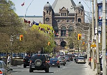
University Avenue begins at the intersection of Front and York streets near Union Station and heads northwest for a short distance before turning north. Lanes on the left end as a ramp to an underground parking garage. At Adelaide Street West, the avenue divides slightly, leaving room for a median of greenery and sculptures between the north and southbound lanes. The avenue ends at College Street, where it splits into Queen's Park Crescent East (northbound) and Queen's Park Crescent West (southbound). Between these two roads is Queen's Park, the home of the Ontario Legislative Building. This landmark creates a terminating vista for those looking north along University. The legislature's site was originally home to the main building of the University of Toronto, and this is the origin of the avenue's name. Today, the university surrounds the legislature building. Queen's Park Crescent is a single street north to Bloor Street.[3]
Avenue Road[]
Avenue Road is the western limit of the former town of Yorkville. At its southern terminus, it runs between two of Toronto's major hotels, the Park Hyatt (on the northwest corner of Bloor and Avenue Road) and the Four Seasons Hotel. On the northeast corner of the intersection with Bloor is the Church of the Redeemer. For much of its length the road is fairly residential, with a mix of small businesses, as well as a few large schools and churches. A notable site along this "lower section" is the Hare Krishna Temple, formerly the Avenue Road Church, opposite Dupont Street and across the street from the Anglican Church of The Messiah. Just north of St. Clair Avenue, Avenue Road is interrupted by Upper Canada College, ending at Lonsdale Road and resuming again at Kilbarry Road. The primary traffic route runs east of the school, following widened sections of Lonsdale Road and Oriole Parkway and returning to Avenue Road via Oxton Avenue.[2][3]
North of Eglinton Avenue, the former St. James-Bond Church once stood. This building, which used to house two prime downtown congregations – St. James Square (formerly Presbyterian), and Bond Street (formerly Congregationalist) – was built in the late 1920s, and closed in June 2005. It has since been demolished. Near Lawrence Avenue is Havergal College, a large private girls' school. Although in the former city of North York, much of the area considers the school part of North Toronto. Avenue Road ends at Bombay Avenue, just after crossing Highway 401 (Exit 367).[2][3] Originally, Avenue Road continued from what is now the interchange by angling northeast via the Hogg's Hollow Bridge (across the Don River West Branch) to end at Yonge Street; this section of the road was incorporated into Highway 401 when it was constructed in the 1950s.[4]
History[]

Prior to the 1920s, Avenue Road ended north of St. Clair, at Upper Canada College. Short disconnected segments existed north of the college near Eglinton and Glencairne, but otherwise the present route was unabated farmland.[5] Seeking to remedy the impediment of the deep valley that Yonge Street (Highway 11) dove into at Hogg's Hollow, the Department of Highways (DHO), predecessor to the modern Ministry of Transportation of Ontario (MTO), sought to construct a high-level bridge. Construction began in early 1928, with the bridge opening on January 5, 1929, providing a much needed bypass of the deep ravine. Yonge Boulevard crossed the bridge, connecting to Highway 11 north and south of the valley.[6] While under construction, the City of Toronto and DHO examined a new route parallel to Yonge Street south to the lakefront. While Bay Street and Duplex Avenue received some consideration, traffic engineers determined that an extension of Avenue Road would provide the most ideal route.[7] It was initially proposed that Avenue Road cut through Upper Canada College, but this plan was rejected as the city did not have expropriation rights through the property, nor could it afford the price asked by the college.[8] The city instead opted to construct Oriole Parkway to Eglinton Avenue, and Avenue Road north of it. The route was paved as far north as Strathallan Boulevard by the autumn of 1928.[7][9]

On January 21, 1931, the DHO assumed 2.00 kilometres (1.24 mi) of roadway leading to the bridge, providing a connection between Wilson Avenue at the planned extension of Avenue Road, and Yonge Street south of Sheppard Avenue, which was designated as Highway 11A.[10] The DHO then began construction on the missing link in Avenue Road between Strathallan Boulevard, near the Toronto city limits, and Wilson Avenue. This section was paved and opened to traffic on October 13, 1932.[11] Although maps, including the Official Ontario Road Map, indicate that Highway 11A continued south into Toronto,[12] the segment south of Otter Crescent (the former boundaries of the old city of Toronto) was entirely built and maintained by the city.[13] Despite this, the city opted to sign the almost the entirety of Avenue Road, Queen's Park Crescent, University Avenue, and York Street, as well as the route around Upper Canada College via Eglinton Avenue, Oriole Parkway and Lonsdale Road as part of Highway 11A.[12]
In the late 1940s, planning began on a new bypass of Toronto, which would become Highway 401. Upon its completion between Bathurst Street and Yonge Street in December 1952, Highway 11A was truncated to an interchange with it immediately north of Wilson Avenue.[14] The Hogg's Hollow bridge was incorporated in the new freeway, and continues to support the eastbound express lanes.[4] Following the creation of Metropolitan Toronto on April 15, 1953,[15] the new municipality was given responsibility for most of the provincial highways that passed within its boundaries. Highway 11A was accordingly turned over in its entirety on January 15, 1954.[16] Metropolitan Toronto continued to sign the route from the Gardiner Expressway to Bombay Avenue, immediately north of the interchange with Highway 401 until the late 1990s.[3]
Major intersections[]
The following table lists the major junctions along Highway 11A, as noted by the Department of Highways.[1] The entire route was located in Metropolitan Toronto.[1]
| Location | km[1] | mi | Destinations | Notes | |
|---|---|---|---|---|---|
| Old Toronto | 0.0 | 0.0 | York Street ramp | ||
| 0.5 | 0.31 | Front Street | |||
| 0.8 | 0.50 | King Street West | |||
| 1.2 | 0.75 | Queen Street West | |||
| 1.7 | 1.1 | Dundas Street West | |||
| 2.3 | 1.4 | College Street | University Avenue becomes Queens Park Crescent | ||
| 3.4 | 2.1 | Queens Park Crescent becomes Avenue Road | |||
| 4.1 | 2.5 | Davenport Road | |||
| 5.5 | 3.4 | St. Clair Avenue West | |||
| 5.9 | 3.7 | Lonsdale Road | Highway 11A turned east onto Lonsdale Road; Avenue Road interrupted by Upper Canada College | ||
| 6.1 | 3.8 | Oriole Parkway | Highway 11A turned north onto Oriole Parkway | ||
| 6.7 | 4.2 | Oxton Avenue | Highway 11A turned northwest onto Oxton Avenue | ||
| 7.0 | 4.3 | Avenue Road | Highway 11A turned north onto Avenue Road | ||
| 7.8 | 4.8 | Eglinton Avenue West | |||
| 9.9 | 6.2 | Lawrence Avenue West | |||
| North York | 11.9 | 7.4 | Wilson Avenue | ||
| 12.2 | 7.6 | ||||
| 12.4 | 7.7 | Bombay Avenue | |||
| 1.000 mi = 1.609 km; 1.000 km = 0.621 mi | |||||
References[]
- Sources
- ^ a b c Ontario Road Map (Map). Cartography by C. P. Robins. Department of Highways. 1954. § Mileage Tables. Retrieved September 27, 2021 – via Archives of Ontario.
- ^ a b c Google (October 22, 2021). "Highway 11A – Length and Route" (Map). Google Maps. Google. Retrieved October 22, 2021.
- ^ a b c d e Golden Horseshoe StreetFinder (Map). 1:29,500. Cartography by Rand McNally. Allmaps Canada. 1996. pp. 50, 59, 67. §§ M5–14.
- ^ a b Filey, Mike (January 5, 2019). "The Way We Were: Tribute to 90-year-old 'Hogg's Hollow Bridge'". Toronto Sun. Retrieved October 20, 2021.
- ^ Toronto, Ontario – Map Sheet 030M11 (Map). 1:63,360. Cartography by Geographical Section. Department of National Defence. Retrieved October 18, 2021.
- ^ Filey, Mike (2000). "Bridge to Canada's Superhighways". Toronto Sketches 6 : "the way we were". Dundurn Press. pp. 237–239. ISBN 1-55002-339-X. Retrieved October 30, 2021.
- ^ a b "North and South Arteries Needed to Relieve Yonge". The Toronto Daily Star. January 12, 1928. p. 36.
- ^ "The Avenue Extension is Needed". The Toronto Daily Star. May 25, 1932. p. 6.
- ^ "Avenue Rd. Extension Delay Disappoints North Toronto". The Toronto Daily Star. September 21, 1928. p. 8.
- ^ "King's Highways Assumed in 1931". Annual Report (Report) (1930 and 1931 ed.). Department of Highways. October 24, 1932. p. 78. Retrieved October 18, 2021 – via Internet Archive.
- ^ "Activity Around and in the Northern Sections of Toronto". The Globe. October 13, 1932. p. 11.
- ^ a b Ontario Road Map (Map). Cartography by D. Barclay. Ontario Department of Highways. 1934–35. City of Toronto inset. Retrieved October 21, 2021 – via Archives of Ontario.
- ^ "Pavement Construction in 1932". Annual Report (Report) (1932 ed.). Department of Highways. March 5, 1934. p. 24. Retrieved October 20, 2021 – via Internet Archive.
- ^ Ontario Road Map (Map). Cartography by C. P. Robins. Ontario Department of Highways. 1953. Toronto inset. Retrieved October 21, 2021 – via Archives of Ontario.
- ^ Rose, Albert (April 1, 1964). "A Decade of Metropolitan Government in Toronto". Buffalo Law Review. 13 (3): 539. Retrieved October 21, 2021.
- ^ "Appendix No. 3 – Schedule of Assumptions and Reversions of Sections of the King's Highway System for the Fiscal Year Ending March 31, 1954". Annual Report (Report) (1954 ed.). Department of Highways. March 31, 1954. p. 156. Retrieved October 20, 2021.
| ( • help)
|
Major roads, highways and streets in Toronto | |||||||||
|---|---|---|---|---|---|---|---|---|---|
| North–south |
| ||||||||
| East–west |
| ||||||||
| |||||||||
| |||||||||
Ontario Provincial Highway Network | |||||||||||
|---|---|---|---|---|---|---|---|---|---|---|---|
| |||||||||||
| |||||||||||
| |||||||||||


- Toronto highways
- Former Ontario provincial highways
